The purpose of this tour was to visit some very scenic places along the south east coast, to cycle north of Mýrdalsjökull to Geysir, and then further to Reykjavík or Selfoss. This should take some 12-15 days, leaving 5-8 days for some unplanned detour or a trip to the extreme west (Látrabjarg that is).
The tour was successful in respect of the cycled route and distance, but very unsuccessful regarding looking at the scenic landscape. June had been extremely warm, wet and foggy in the south east, and this weather continued long into July. The extra time were therefore used to spend some days in the north, as the weather usually is good in the north when it is wet in the south.
26th June, Egilsstadir - Kaldakvísl, 31.5 km including detour, 250 m ascent.
Arrived in Seydisfjördur with the new Norröna ferry. Got 15000 ISK (Icelandic króna, 100 krónur is about 1.3 USD) from the hradbanki (ATM) in the Shell gas station. Got back to the ferry terminal in time to catch the 9:00 a.m. bus to Egilsstadir. Icelandic buses have very tiny signs telling where they go, so look carefully. The bus cost 800 ISK. It was raining on the Fjardarheidi. Elevation there is over 600 m, so getting up there by bike would mean that I would be wet from sweat, and cold from rain. The rescue hut was replaced since last year and looked fine from the bus.
In Egilsstadir I assembled the bike and negotiated with the camping site warden about storing my cycle transport rucksack, which she accepted without charging anything. Thanks. I found that all my gear would not fit into the panniers and top packsack, so I needed to buy an extra waterproof soft bag for clothes and wading shoes. I couldn't find such a bag in Egilsstadir. An almost waterproof hard plastic toolbox was purchased for 2995 ISK instead. It did the job, but as it was incompressible, it increased the sensitivity to crosswinds, which had some consequences later on.
I found a free Internet connection in Safnahúsid (a museum and library), a large grey building in the north east part of the town.
I started cycling rather late in the afternoon, towards Reydarfjördur I thought, but I hadn't read the map very well, so after 11 km cycling in headwind I found myself on the road to Breiddalur instead. I wanted to follow the coast, so I turned back and took the right road. It started uphill, and after 8.5 km the sunny weather seemed to change to rain and the wind to headwind. Since the pass is at 380 m elevation, the weather would be worse there, so I put up the tent in the shelter of a low hill near Kaldakvísl (the cold forked river, it separates into two small creeks higher up).
27th June, Kaldakvísl - Reydarfjördur, 30 km, 200 m ascent.
The rain continued until 2 p.m. I spent the morning studying Russian. Started cycling at 3:30 p.m., but the rain came back before I reached the pass and the rescue hut there. I stopped at the hut and had dinner inside. The hut was rather deteriorated, no floor, people had even been shitting inside. I continued after dinner down to Reydarfjördur, still in some rain and headwind, took one hour. I was close to colliding with a young horse belonging to a horse riding party just before the town. It was running on the same side of the road towards me and changed suddenly to the opposite side of the road just in font of me.
I looked for a place to stay indoors, found only Hótel Foss, which cost 12100 ISK, about 10 times my budget level. Went to Andapollurin camping just west of town. It was free. I was the only guest. Rain during the night.
28th June, Reydarfjördur - Fáskrúdsfjördur, 57 km, 300 m ascent
Everything wet. Cycled around in Reydarfjördur and found Thórsmörk gistihús, which offered svefnpokapláss (sleeping bag accommodation) for 1700 ISK. That would have been better.
Reydarfjördur is the place where a big aluminum smelter is to be built, using power from the planned Karahnjúkar hydropower plant in Fljótsdal, south west of Egilsstadir. I read in the newspaper that the fish oil tanks in Reydarfjördur had been sold and towed to another place and that an enormous haul truck had been taken ashore in Eskifjördur and driven to the hydropower plant construction area.
Had a disgusting deep fried chicken breast lunch for 1045 ISK at the local gas station. Cycled in dry but cloudy weather and light to moderate headwind to 65 degrees N, 14 degrees W, which was about 700 m south of the road. About 6 km was gravel road, the rest fine tarmac road. I continued to Vattarnes, the eastern promontory, where the road is cut in the cliffs. I started raining again and the headwind became worse, and 4 km were gravel road. Rockfalls make many holes in the road, so it is not paved. The last 10 km to Fáskrúdsfjördur were fine and in tailwind. I got fine accommodation in Hótel Bjarg for 1800 ISK (svefnpokapláss in a hotel room).
Fáskrúdsfjördur is also known as Búdir, which was the place where French fishermen had their Icelandic dwellings about 100 years ago. Most street names have French names as well as Icelandic, and I met several French tourists.
29th June, Fáskrúdsfjördur - Berunes, 71 km, 300 m ascent
Left hótel Bjarg at 10:35 a.m, foggy. Could at a few places see some mountains, but suddenly, near Stödvarfjördur, the skies cleared at the weather became warm and sunny and the wind disappeared. Stopped at the local food store and bought a small tin can of Icelandic fish and some milk, which I shared with a small cat. After a long rest I continued on the south side of the fiord. Met an Austrian cyclist. Then headwind and fog again, and even some rain at Kambanes and in to Breiddalsvík. Found myself to be only 81 km from the starting point in Egilsstadir. Continued in fog and some drizzle to Berunes, where the farmer Ólafur has a youth hostel in the old living house. Got accommodation and 1 litre of fresh milk from his cows for 1550 ISK. He had 13 producing cows, and a total of about 30 head. Very nice place. Ólafur said the weather had been the same all of June, and that the grass didn't have much energy in it because of lack of sunshine and much rain. He said June usually is the driest month in Berufjördur.
6 km + 3.5 km of gravel road this day and 5 hours 40 minutes of active cycling.
30th June, Berunes - Djúpivogur, 42.5 km, 200 m ascent
Could see over the fiord to Djúpivogur and some mountains at 3 o'clock a.m. Used an hour or so in the morning to service the bike and left Berunes at 1:00 p.m. in light SE wind, low clouds, but dry weather. Didn't see anything of the beautiful mountains Smátindar, Kvensödla and Búlandstindur and none of the Iceland gyr falcons that should be around. Came to the Öxivegur crossing and found myself now being only 65 km from Egilsstadir. With the weather I had, it would have been better to take the Öxi road. I later met two Swedes, who had cycled over Öxi. It is gravel road, fairly narrow, very steep on the southern side, no fords. They had even met a truck with trailer. Highest elevation was a little over 500 m they said. The gravel road had started already 15 km south of Egilsstadir, so it should be 50 km of continuous gravel. I also met a German lady, who said it had rained a lot when she cycled along the south coast. Despite that, she looked happy. Arrived in Djúpivogur at 4:40 p.m. and put up the tent at the campsite (500 ISK). Near Djúpivogur is Teigarhorn, a geological reserve with rare minerals.
1st July, Djúpivogur - Stafafell, 73.5 km, 250 m ascent altogether (10 - 100 m each)
Met the two Swedes Martin and Daniel as mentioned above. I went to the post office and sent 800 grams of stuff home. Started towards Stafafell at 11:00 a.m. in dry but cloudy weather. Saw 80 whooper swans in Hamarsfjördur, 60 in Álftafjördur (Swan fiord) and over 100 in Lónsvík. 4 + 5 + 4 km of gravel road and roadworks. Arrived in Stafafell at 5:30 p.m. The youth hostel in the old living house was fully booked. However, I visited Stafafell already in 1977, while the family still lived in the old house, and also a few times later, so Bergsveinn recognised me, and even remembered the ABBA record I had sent to him and his brothers Sigurdur and Gunnlaugur as a Christmas gift in 1977. I got a room in the new living house and could use the kitchen in the youth hostel. Fine, thank you, Bergsveinn, Svalla (B's wife from Switzerland) and Sigurdur. Jean-Rémy from France was hostel warden during the summer and tried to learn some Icelandic.
2nd July, Stafafell - Hrollaugsstadir, 93 km, 400 m ascent
Left Stafafell at 9:45, just as the rain started. 5 km of gravel road over Vestrahorn pass, 200 m ascent there and very steep descent. Bought a nut for 6 ISK at a car spare part shop in Höfn and had a meal at the restaurant. The rain ceased for half an hour while I was in the restaurant, but started before I got on the bike again. Cycled in continuous headwind and rain to Vagnsstadir (met two German girls half way, they had tailwind at least). There was no vacancy in Vagnsstadir, so I continued some 3.5 km in heavy rain to Hrollaugsstadir, where I got a svefnpokapláss for 1000 ISK in the school house + 900 ISK for breakfast next morning. Saw two black-tailed godwits and over 100 whooper swans during the day. It had been raining 100% of the time on the bike this day.
3rd July, Hrollaugsstadir - Skaftafell, 81 km, mostly flat.
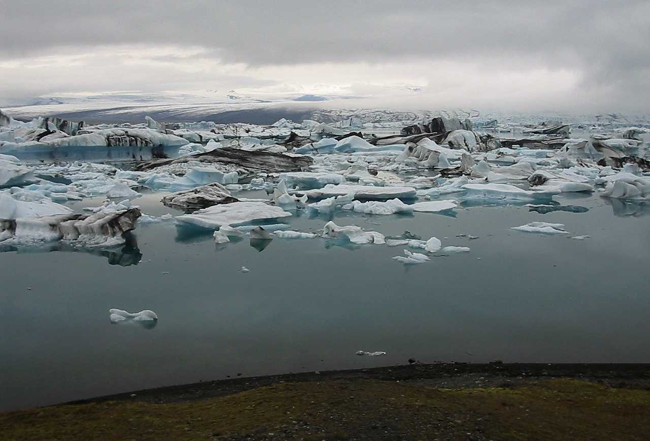
Started at 10:40 a.m. in the usual light rain, but after half an hour the raining ceased. Arrived at noon in Jökulsárlón, where it is a restaurant and sightseeing tours are made with amphibian vehicles to the glacier calving area, where it sometimes is possible to go with the vehicles in ice caverns. The weather got better for a while, and I got some pictures of the icebergs in the lake. The distance between the lake with the icebergs and the sea is only a kilometre. I saw many seabirds and a few seals were in the area.
The Swedes David and Martin arrived at 14:30 p.m., just as I was ready to leave Jökulsárlón. We talked a while, then I continued along Breidamerkursandur, a wide gravel plain. Near Kvísker I took some photos of an arctic skua couple with a young offspring that hid in the grass, and whose position was revealed by the parents’ attack pattern while I was walking along the road. Briedamerkursandur houses the main Great skua population in the world, and I saw several of those flying over the sandur at a distance. I never got close enough to bother to take a picture, since I kept cycling on the road and I have some pictures of them from earlier visits. Great skuas may attack very vigorously close to their nests and offspring.
I arrived in Fagurhólsmýri at 16:30 and had a small bowl of asparagus soup for 430 ISK, very expensive, but the gas station on the spot is the only place to get some food.
Regular tours to Ingólfshöfdi (puffins and other seabirds) are offered by the farm Fagurhólsmýri. There is no road, they drive on the flooded mud plain, knowing exactly where to go and not to go. Ingólfshöfdi is named after Ingólfur Arnarson, who came here in 874 as the first Norse settler on Iceland. However, for some reason he decided not to put up his settlement in southeast Iceland, at that time having very wide grass plains. He settled at the harsh lava plains where Reykjavík is today. The grass plains were almost totally destroyed in big volcanic eruptions and glacial water floods in the 14th and 18th centuries. In Icelandic newspapers I could read about fears of the volcano under Eyjafjallajökull erupting any year to destroy the agricultural heart of Iceland west of Eyjafjallajökull and Mýrdalsjökull, including towns Hella and Hvolsvöllur.
When I left Fagurhólsmýri at 17:30 it started to rain again. I just cycled on till I reached Skaftafell campsite in the national park with the same name at 19:00. Tenting cost 600 ISK. David and Martin arrived later and had had rain all the way from Jökulsárlón.
4th July, resting in Skaftafell
Rain and 9 degrees centigrade in the morning, the rain ceased around noon. Icelandic wrens (bigger than other wrens) were singing in some of the birches around the campsite. I made an attempt to visit 64 degrees N, 17 degrees W, but found it to be on a gravel bank in the braided river Skeidará, that contains much of the melt water that leaves Vatnajökull to the south. I got no closer than 424 m on one of the protection dams that have been put up on the east bank of Skeidará. Irregularly the volcano at Grímsvötn under Vatnajökull erupts and melts some cubic kilometres of ice, which then lifts the ice and floods the sandur plain. This happened in November, 1996, and at maximum flood some 50 000 cubic metres per second of heavily loaded water forced its way to the sea and destroyed the bridge and part of the main road. There are some remnants of the bridge put up as a monument just east of the repaired bridge. Videos showing the event were regularly presented in the visitors’ centre at Skaftafell.
Together with Daniel and Martin I also visited the Svartifoss waterfall. It flows over a precipice consisting of very dark columnar basalt. Saw a ptarmigan near the waterfall.
5th July, Skaftafell - Kirkjubaejarklaustur, 74 km, two 20 m hills.
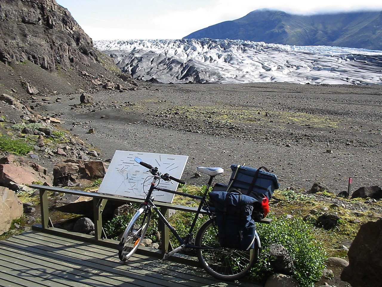
Clearing skies in the morning, sunny from 8 to 12 o’clock. I made a short trip to the Skaftafellsjökull glacier front. Left Skaftafell at 11:00 and cycled across Skeidarársandur. Saw only one arctic tern and one whimbrel on the 30 km across the plain. Quite different from Breidamerkursandur that had much birdlife. Passed the 671 m high precipice Lómagnúpur, impressing. Nesting fulmars in the cliff.
Increasing wind from the south and later rain made it difficult the last hours to Kikjubaejarklaustur. When oncoming trucks passed, the wind pressure suddenly ceased and I made involuntary detours to the left. I stopped when I saw a caravan coming form behind.
There is a hostel in Hvoll, about one km south of the main road, but I chose to continue to Kirkjbaejarklaustur where there is a big foodstore. It was raining intensely when I arrived there. I stayed at the Sumarhótelid (in a schoolhouse beyond the bigger hotel and close to the swimming pool). It cost 1300 ISK, and a reasonably good dinner 1500 ISK. Smell of fungus in the classroom I got as a svefnpokapláss. Looked at the weather forecasts in the text-TV. Disappointing.
6th July, Kirkjubaejarklastur - Hólaskjól, 63 km, 500 m ascent
Rainwater was leaking trough the window. Smell of fungus increased. I moved to another classroom during the night. Pouring rain and strong wind gusts in the morning. I cycled to the town centre, got 20 000 ISK from an ATM and bought some food. Watched text-TV weather forecasts. Maybe a chance of drier weather. Prepared for immediate take off, so when the rain ceased, I left (at 15:55). Strong tailwind over Landbrot - Eldhraun. Turned north at the crossing Ring road x F208 (Fjallabaksvegur nyrdri). According to a sign, 75 km to Landmannalaugar. A good deal of uphill riding and after the Búland farm, somewhat rough road. The last half hour of cycling, it was raining a little. Reached the Hólaskjól campsite at about 21:00, after 38 km on road F208. Hólaskjól is at 327 m asl. Met Marcus and Tanja from Chur, Switzerland. They came from Landmannalaugar on a Swiss Koba and a French unnamed bike.They had experienced much rain and strong headwind all day. Tanja had crashed (or fallen) while fording one of the rivers and all her luggage was soaking wet. We turned off the gas stove during the night, since Marcus and Tanja thought it might poison us to death if the fire went out.
7th July, Hólaskjól - Landmannalaugar, 40 km, 600 m ascent
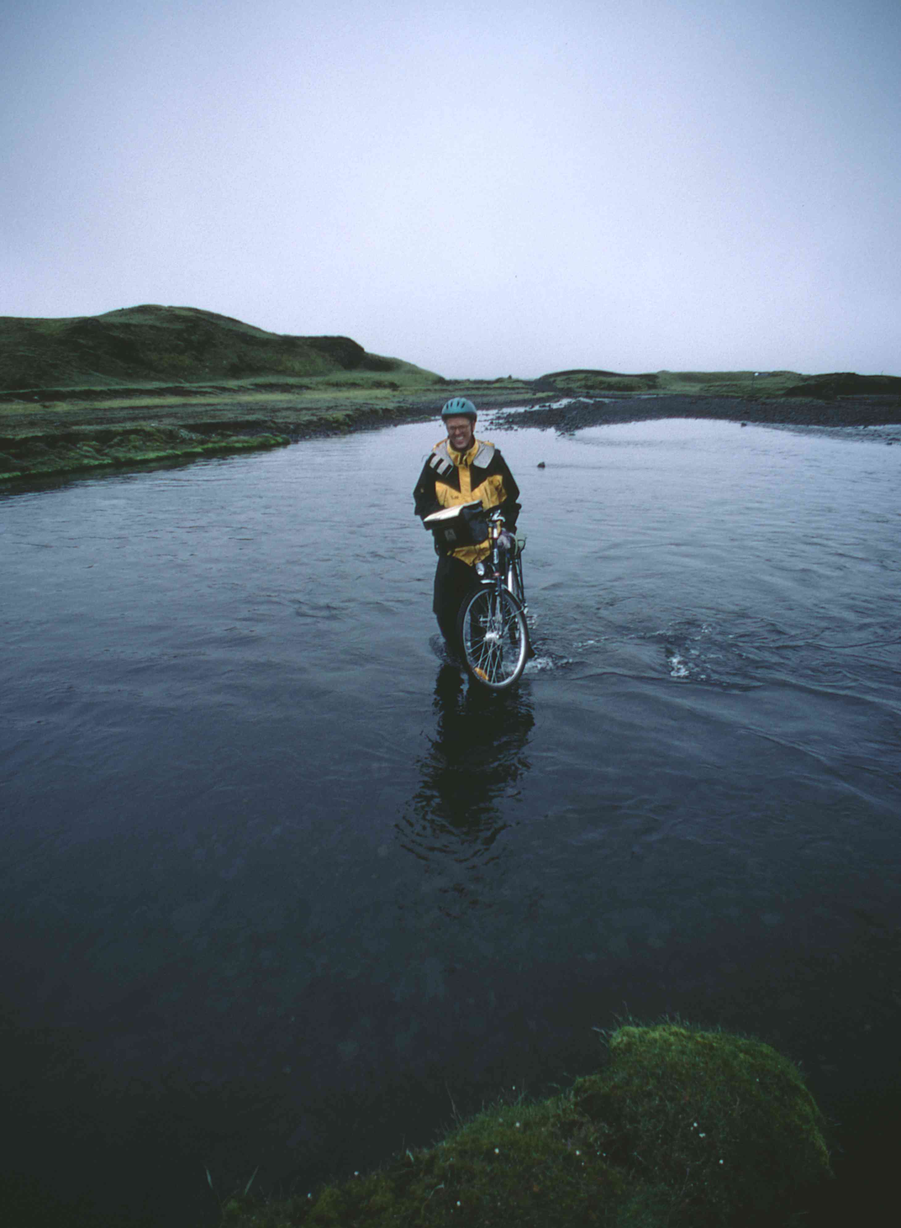
Left Hólaskjol in misty weather at 10:30. Came to the first ford in Eldgjá, which is one of the volcanic fissures in a system that divides Iceland in two parts, one belonging to America and the other to Europe. Iceland is on top of a hot spot on the mid-atlantic ridge, the spreading zone where oceanic crust is formed from up-welling lava. The American and Eurasian continents are pushed apart by this process and Iceland becomes two centimetres wider (as an average) per year. Eldgjá is the biggest volcano in this system of fissures. It’s fissure is 30 km long and the lava flows cover 700 square km. I carried the luggage and bike over to America. I didn’t need to take off my Wellingtons (high rubber boots). A French man took a picture of me with my camera, thanks.
After Eldgjá it was a lot of uphill, sometimes so steep I had to walk (over about 14 %). The road crossed several small streams. I cycled over most of them. I led the bike across a few streams where the bottom was loose sand or coarse gravel. It was raining at the higher elevations, but I had a weak to moderate tailwind most of the time. Passed the highest elevation (720 m asl) just west of a road intersection. The crossroad was a mountain track leading to Faxasund. After this much downhill. Rain and gusty winds again. I had to walk down. It was to steep to dare braking downhill on the loose, wet gravel. I saw Marcus’ and Tanja’s tracks at several places. They had walked uphill. I reached a gorge with a river. The road was going along the gorge and passed the river several times. In 1975 I had been warned against driving with a Land Rover in this river. The water was reportedly 1 metre deep. Now it was 20 cm, and no problem at all, despite intense rain the last month. 1975 was a very dry year, so I wonder if the reported depth was overestimated 10 times. In 1975 I drove another road with the Land Rover and got into real problems of getting further closer to Mýrdalsjökull (on Fjallabaksvegur sydri) and had to return to the road no 1.
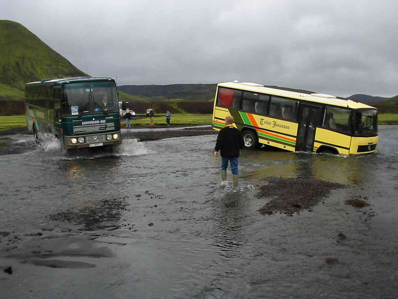
The largest ford on Fjallabaksvegur nyrdri was across Jökulgil. A tourist bus had driven over the steepest part of the river bank and down in the water where it was about 60 cm deep. It was standing with the front wheels in the river and with the engine drowned. The driver of the regular bus (Kirkjubaejarklaustur - Reykjavík along Fjallabaksleid) didn’t dare to cross the river, but when the R-vík - K-klaustur bus came, its driver speeded over the river on the right place (which was about 20 m upstream), and the two busses exchanged passengers and then returned the way they came. A common passenger car also managed to get over, as well as a couple of terrain vehicles (SUV’s in American). It is illegal for common cars to drive on F208. I carried my luggage over and then the bike. It had my Wellingtons on all the time and didn’t get wet. The last ford was in loose sand. I led the bike over with the luggage on.
Since Fjallabaksleid nyrdri passes only some 400 m north of 64 degrees N, 19 degrees W, I visited this confluence point as the first visitor. It is on 674 m elevation and only 3 km from the big tourist trap Landmannalaugar.
The next river is Jökulgilskvísl and it is bridged. Not long after the bridge is a road intersection. I took left to Landmannalaugar, and reached the end of the road after 1 km at Námskvísl, a rather big stream. There was a bridge made of two big wooden power line posts across it. I carried the luggage and the bike separately. I arrived at the campsite just beyond the bridge at 18:00 and paid 600 ISK at the tourist hut. At this campsite you have to choose. Either soft and wet, or very hard and dry. I chose the wet - soft option. After dinner I made a walking tour out on the colourful sandur and another one across the big lava field that produces the heat to the hot springs. Saw two whooper swans.
8th July, Landmannalaugar - Árnes, 84 km, 200 m ascent
I got up at 5:30 a.m. and took a bath in the hot spring. Hot water emerging from under the lava field flows into colder water. Actually the two water flows do not mix easily, as the hot water flows on top, so bathing is quite an odd experience. A wooden structure is built where the bathing place is. After this I slept for another hour.
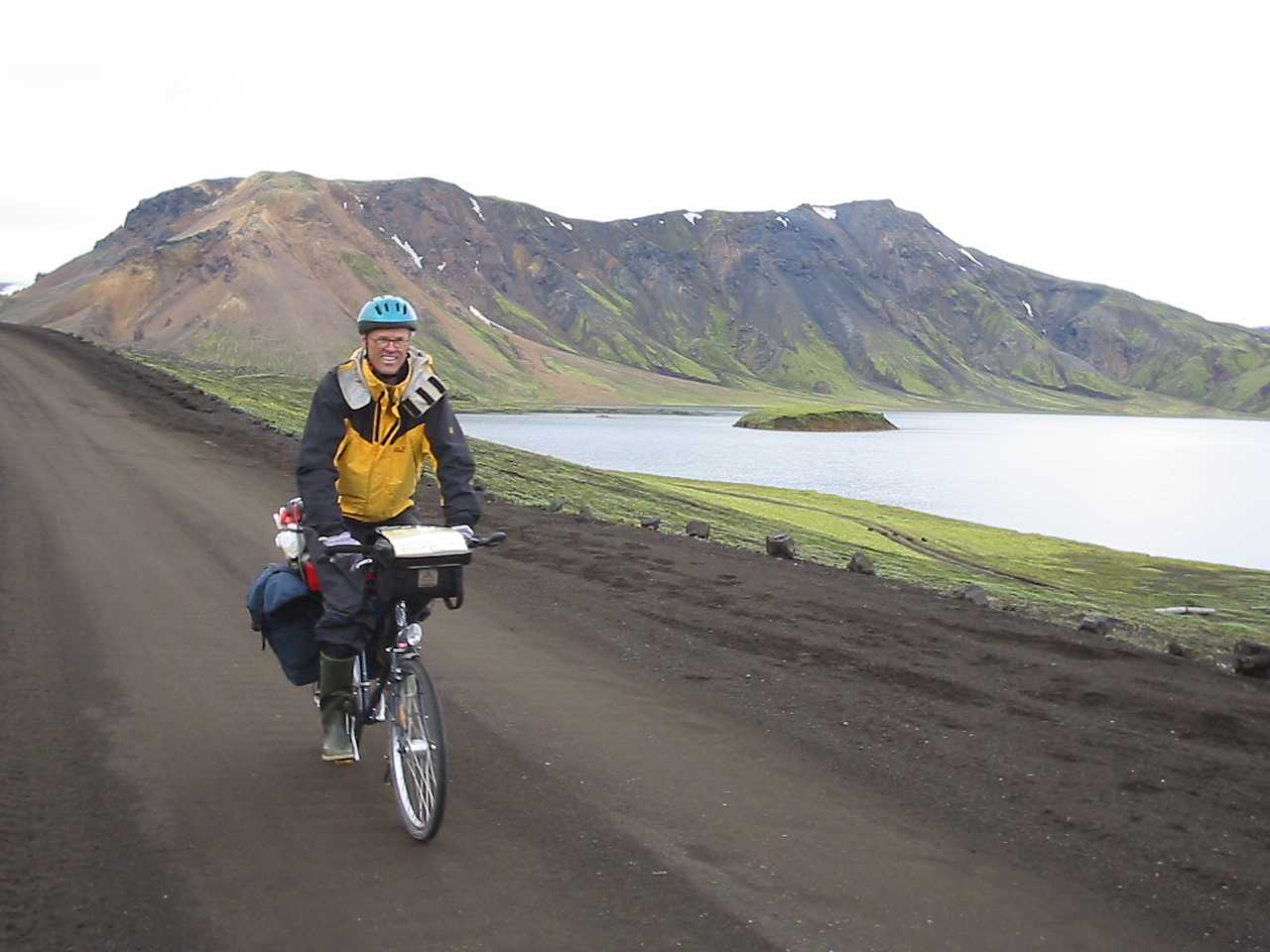
I left Landmannalaugar at 10:30. I passed a road leading to Landmannahellir (caves) where it should be a café and some kind of accommodation, according to the sign. It started raining at Krókagiljabrún. There were a few streams to cross, but none of them was difficult. The rain ceased and the sun shone for a while. I reached a new road intersection at Valahjúkar, took south. The road became very rough with large pebbles. At 16:00, after 48.5 km, I reached road 26 (further north called F26, Sprengisandsleid, and leading to north Iceland. It is still unbridged). I took north but didn’t go further than to the dam across Thjórsá at Búrfellsvirkjun hydropower plant. There were maintenance work going on at the dam. I had to carry the luggage and the bike past a big machine on the dam.
After the dam it was an easy two hour ride to Árnes on road 32 (hard surface). Good weather despite some headwind near Árnes. Had a hamburger and coffee for 690 ISK at the gas station and put up my tent at the campsite (700 ISK) just south of the hotel (paid at the hotel). Calm weather in the late evening. Two Germans on motorcycles arrived. They intended to ride Sprengisandsleid.
9th July, Árnes - Geysir, 50.5 km, 200 m ascent
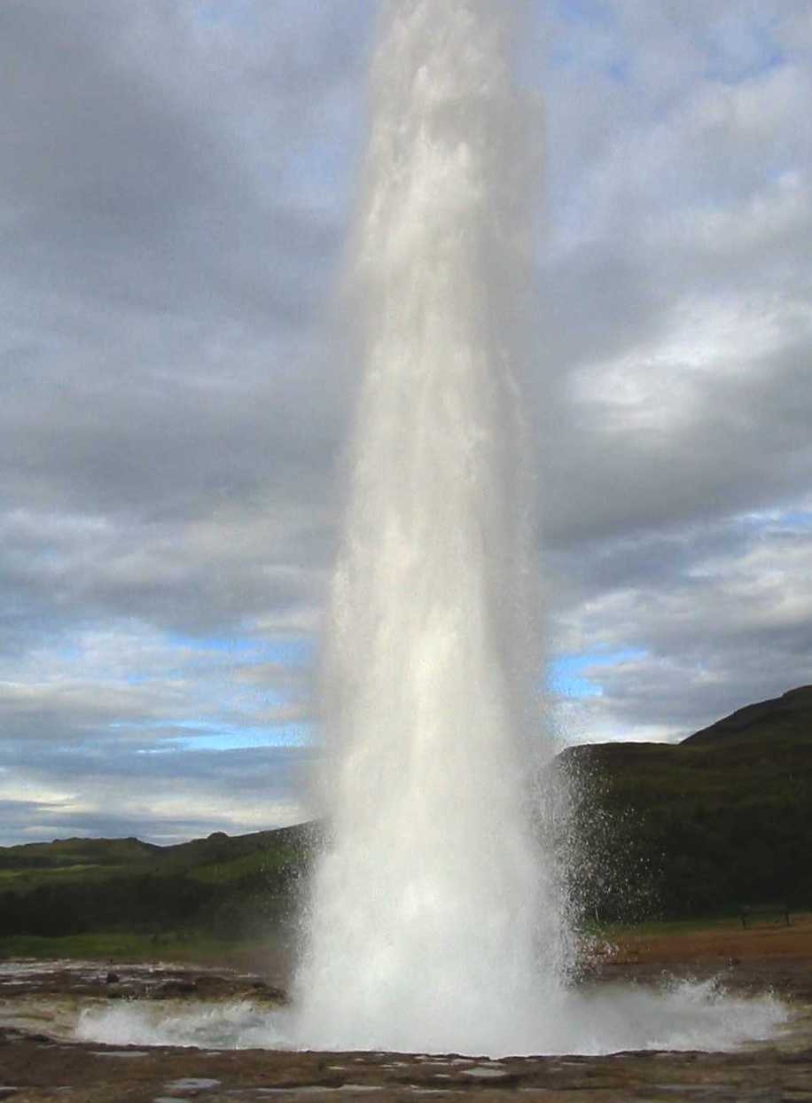
Rain started at 6:30 a.m., hard wind from north east. I used the time to clean the bike and put some glue on the tyre. The tyre wall had started to split, because of too low air pressure. My left shoulder was still in a poor condition after a cycle crash in April, so I couldn’t get more than about half of the necessary pressure in the tyre. I left Árnes at 15:30 in rain and tailwind until the intersection of roads 30 and 32. Then it was a terrible headwind and crosswind, but the rain ceased. I had to get off the bike when the crosswind was at its strongest and walk, because the toolbox on top of my rear rack took up so much wind pressure. I stopped in Flúdir and bought some food. Met two German cyclists that said it was bad roadworks on the road to Geysir. I continued at 18:30. It was asphalt 10 km, gravel 5 km, roadworks (loose gravel) 6 km, gravel 4 km and asphalt 4 km. Wind weakened a lot during the evening. I reached Geysir at 21:45 and paid 500 SEK for camping and shower. I went to Strokkur, which is erupting some 4-6 times an hour, and took some photos despite poor light.
10th July, Geysir - Reykjavík, 118 km, 500 m ascent
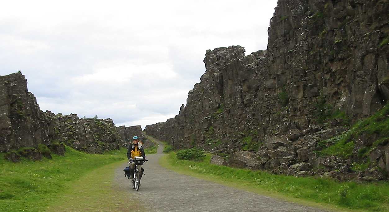
I got a few pictures of Strokkur in eruption when the sun just poured some light over the scene and before the area was crowded. Left Geysir at 10:40 and had tailwind and a few drops of rain to Laugarvatn. There I took the gravel road 365 towards Thingvellir. It started with a climb and the highest elevation was about 300 m. Two of the climbs had hard surface. Mostly tailwind, but black flies followed me. I got a few of them in the throat, not very pleasant. Tarmac descent down to Thingvallavatn. I took north on the new tarmac road to Thingvellir restaurant, but it would have been nicer to turn south and then soon right on to road 361, which is closer to the lake and leads directly to to the old parliament site at Thingvellir. The restaurant was no good, nothing but sandwiches and coffee. I made my own food outside. 3 km to Thingvellir. Saw 6 black-tailed godwits. Canadian photographer Suzanne took some photos of me cycling in Almannagjá canyon, using my camera, thanks.
Thingvellir is nowadays a much calmer place than some 10 years ago. The new road is built 3 km north, so only those who are interested in the historical site go to it. No through traffic any more. Thingvellir was the place where Icelanders met to make decisions at the Althing from about 930 regularly long into the 18th century. In 1798 the Althing was moved to Reykjavík, and the meetings were terminated 1800. A new Althing was established in Reykavík 1845.
I could not find the road leading up to road 36 to Reykjavík, so I cycled back to the restaurant. Then I crossed Mosfellsheidi (highest elevation 240 m) in good tailwind. The rear tyre made bumps. A lot of traffic the last 15 km to Reykjavík. Reached Laugardalur campsite at 19:40. For those who have a GPS, it can be found on coordinates (WGS84) 64 degrees, 8.804´ N, 21 degrees, 52.553´W, close to the large swimming pool building. It cost 700 ISK to tent there. There is a nearby youth hostel. They also took 700 ISK for indoor svefnpokapláss. They had two Internet terminals, only one of them worked, though. From the campsite reception I got the address to the cycle shop Örninn, where I could buy a new tyre. I cycled to Örninn and took its GPS coordinates: 64, 7.856´N, 21, 52.074´W. Had a pizza at Pizza Hut in Hótel Esja building for 1290 ISK.
11th July, Reykjavík, bus to Varmahlid, 23 km cycling, about 300 km bus
Cycled to Örninn early in the morning and bought a new tyre for 2300 ISK. Bought a bigger pump and new brake pads too. Got permission to put on the tyre and brake pads indoors, thanks a lot. Pumped the tyre to 45 psi. Went to Pizza Hut and had a pizza for 990 ISK (special lunchtime prize). Cycled to Umferdarmidstödin BSÍ (Traffic central station) near the domestic airport and purchased a ticket to Varmahlid for 4500 ISK. The weather was very sunny and pleasant, and I cycled to midtown Reykjavík, where there was a large photo exhibition by Yann Arthus-Bertrand in the park outside Althingishúsid (today’s parliament building). Yann’s pictures were very impressive, and all of them had exact coordinates (a few of Icelandic ones with E instead of W longitude, though). Now I could see what the landscape east of Mýrdalsjökull looked like. When I cycled there, I saw a gravel road a few hundred meters at best.
At Laugardalssundhöllin I had a swim tour for 220 ISK, then I took down the tent and cycled backt to BSÍ and took the bus. I got permission to have the bike in the luggage compartment under the bus, after I had split the frame in two pieces (it is equipped with S&S couplers). The cycle rack at the rear of the bus was occupied by two other bikes.
We passed Hvalfjördur tunnel, which had an anniversary celebration and was free. Bicycles are not allowed in this about 7 km long tunnel. One has to go around Hvalfjördur which makes the distance to Akureyri some 50 km longer. The weather was excellent until Holtavörduheidi pass (400 m), where the clouds and fog came in from the north. We arrived in Varmahlid at about 9 p.m. I got the information that there was a route car going to Saudárkrokur the next day at 10:45. I stayed overnight at the Hofhestar campsite about 600 m from hótel Varmahlid towards Akureyri and south of the road no 1. It cost 500 ISK.
12th July, Varmahlíd - Saudárkrókur (route car) - Lágheidi saeluhús, 91.5 km, about 800 m ascent
The route car cost 500 ISK for the 23 km to Saudárkrókur, but I didn’t have to fight the headwind. Started to cycle at 11:20. The wind came from the Skagafjördur bay, and was quite bothering. After a few km, in a downhill km, I got a tailwind, then the crosswind to headwind was back. After 15 km I turned left and had a constant strong headwind north to Hofsós, where I had a meal at the local foodstore. Just south of Hofsós is Grafarkirkja, one of Iceland’s most known churches, but due to the headwind, I didn’t have time to visit it. I stopped just south of Hofsós though, to look at the ruins of the old trade center at Grafarós, abandoned in the early 20th century. After Hofsós I had 25 km of terrible headwind, then the road turned right, and I got a crosswind instead for a short while, then it turned to a headwind again, but weakened. When I reached the gas station at Ketilás at 19:20, it was already closed, so I didn’t get any coffee. I found a water tap on the back side of the building and had some bread. The wind died out, but just as I got on the bike to go south, the wind started blowing again, now from the opposite direction. Headwind again, and uphill. After 6 km on a gravel road I reached Hvammur abandoned farm and visited the confluence point 66 degrees N, 19 degrees W as the first visitor knowing about the Confluence Project. The point is located only 60 m from road 82 between Siglufjördur and Ólafsfjördur and every day several tens of people pass within the qualifying 100 m from the point. I continued to Knappsstadir 3 km further south. This farm was abandoned around 1975, but it was now used as a summer vacation house. I spoke to the people there and they showed me the Knappsstadir church, which is Iceland’s oldest timber church, erected 1837. I passed this place on a mountain hiking tour on 13th July 1975, so it was almost a 28th anniversary. I continued in strong headwind and uphill at about 9 p.m. The road made a turn about 150 degrees and it started raining, but it was still headwind. I concluded the wind was flowing along the valley irrespective of the direction of the valley, and that the main wind direction most of the day had been from the north, turning to the northeast during the afternoon. At 350 m elevation I got into clouds, and when I found the Lágheidi saeluhús at 392 m elevation, I stopped there. It was a few hundred meters to a small stream to get water. There was a visitor’s book inside, so when the rain hadn’t stopped at midnight, I decided to stay overnight at the place. I had seen about 20 black-tailed godwits during the day.
13th July, Lágheidi - Akureyri, bus to Mývatn (100 km), 92 km cycling, 450 m ascent
Got up at 6:25, 7 degrees centigrade outdoors and 9 degrees indoors, 6 - 10 m/s NE wind, foggy, a few raindrops. The fog cleared a bit and I got away at 8:05. 14 % downhill wet gravel road. Took it in a slow pace. 34 km of gravel road and 3 km tarmac between Ketilás and Ólafsfjördur. Everything closed in Ólafsfjördur. Met a Norwegian farmer on the closed gas station. Camping free of charge near town center, looked good. Continued in fog and rain and came to Múlagöng tunnel, 3520 m long, slightly uphill all the way. After the tunnel downhill, tailwind and some rain. Reached Dalvík and stopped at café Axid, very nice place. Then I continued in dry weather to Akureyri, where I arrived at 14:05 after riding 81 km. Rode to Umferdarmidstödin and bought a ticket to Mývatn (Reykjahlíd) for 2000 ISK + a horrendous 800 ISK for the bike. Visited the renovated net-café at the town centre, the Jón Sprettur pizza outlet (900 ISK for a midsize pizza) at the uphill part of the town. Then I rode to my friend Gunnar and spoke to him and his wife Júlia until 18:00. Got down to Umferdarmidstödin, where a music band was training in a nearby corrugated steel shed. Doors open, the sound that came out was impressive in loudness, the least to say. I went inside. The steel walls made the sound bouncing around, the sound level was clearly unhealthy, the music style impossible to define. In a pause I asked about the name of the band. ”We haven’t decided yet”. A suitable name.
The bus left Umferdarmidstödin 4 minutes before departure time. After some 10 km, a car passed us, signalled with the horn and stopped. One passenger had missed the bus. Then the bus driver was driving 4 - 5 metres behind a car, and when the car slowed down to turn right, the bus almost hit it. The bus driver shouted something in anger, but I think the bus driver should have chosen some other profession. He was driving much faster (70 km/h) than the speed limit (30 km/h) on a rough roadwork section, so I feared my bike would be damaged and asked him to slow down, which he did for some hundred meters. He was much too early at all bus stops along the way.
In Reyklahlíd I paid 600 ISK at the campsite, then went to Stóragjá (2 km) for a 1 ½ hour swim in the caves. Nobody else was there.
14th July, Reykjahlíd - Grímsstadir, 55 km, 200 m ascent
It was raining all the night. Had another half hour swim in Stóragjá. Lost my gloves on the way, had probably forgotten them on a bench outside the foodstore. Visited Grjótagjá cave (50 degrees in the water) and Hverarönd. Saw several people swimming in the lagoon close to the factory, but it was too cold in the air to be pleasant to change to swimsuit outdoors, so I didn’t take a swim there. A few minutes of sun at Hverarönd sulphur pool area (solfataras). Then I continued eastward to across the desert like land to Grímsstadir, where I got a svefnpokapláss for 1700 ISK in the old house of the Grímstunga farm. Four German motorcyclists came. They were very kind. One of them, Martin Trosche, had a 1942 BMW army 3 wheeled motorcycle which carried 180 kg of load (much of it was beer, 10 cans had broken, though). They had been riding across central Iceland, essentially along Sprengisandsleid. They had taken their bikes to Iceland on a freight ship, while they went by air.
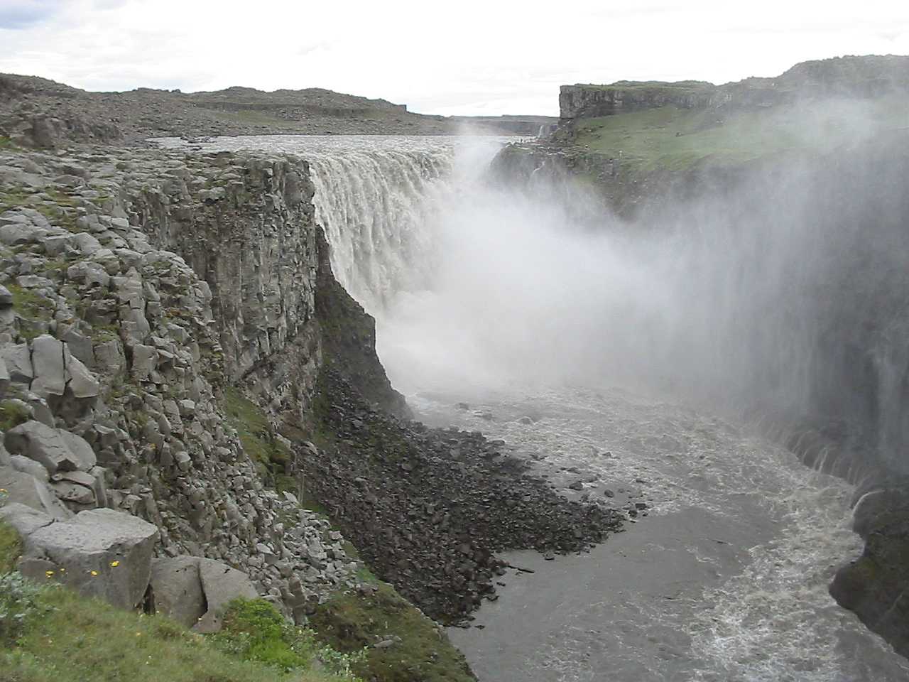
15th July, Grímsstadir- Dettifoss - Grímsstadir - Egilsstadir, 194.15 km, maybe 900 m ascent
Tried to get away early to reach Dettifoss, the most powerful waterfall in Europe, before the busloads of tourist that go there. Beautiful weather, crosswind, but 6 km of bad loose gravel on a roadwork. I was much too late. Had a hard time to get a picture of Dettifoss without a tourist in an odd posture on the hilltop on the other side of the river, but still with sunshine on the water curtains below the waterfall. Got the picture after 1 ½ hour of waiting. I hope the picture wasn’t destroyed by a black fly.
I cycled back the 30 km to Grímstunga, had a big lunch and took off at 14:30 towards the east coast.
The 4 kilometres from Grímstunga to road no 1 junction near the bridge over Jökulsá á Fjöllum were a smooth dirt road. Then 13 km were asphalt on road no 1. The next 25 km were across a hilly, rather barren land. 6 km were a terrible roadwork area with loose gravel and dust. 25 km from Jökulsá, at Vegaskard, there was a steep descent from elevation 550 m down to some 480 m, then the road divides. One branch is the old gravel road past Mödrudalur, where accommodation in a turf house was advertised. The distance from the junction to Mödrudalur is 8 km. The other branch is the new, mostly hard surface, road no 1. The highest elevation, 595 m was passed about 5 km after the road junction, at Thjódfellsbungur. Had a dinner in Langidalur at the first creek. Road no 85 to Vopnafjördur connects about 22 km from the road to Mödrudalur, not 11 km as drawn on the 1:500 000 map from year 2000. Elevation there was 486 m. Then it was easy riding to the next junction with the road past Mödrudalur. This junction was at elevation 555 m. Then it was only 3 km asphalt road, so the downhill 10% for 2.5 km down to Jökuldalur was on a poor gravel road. After the first bridge in Jökuldalur it was all hard surface road to Egilsstadir. I just pushed on, stopped in fog at the Jökulsá bridge and ate some sugar to get more fuel to the ascent (highest elevation 250 m) up to Lágheidi. Then it was downhill in fog all the way to Egilsstadir, at 31 m elevation. I felt like flying. Got to the camping ground at 02:25, 131 km from the road junction at the Jökulsá á Fjöllum bridge. The cycled distance this day and night was a new record 194.15 km. 13 hours and 17 minutes in the saddle.
16th July, Egilsstadir - Seydisfjördur, 38.5 km, 600 m ascent
Got up at about 9 a.m. Fine weather. Cycled south 5 km to get a photo of Snaefell, 1833 m. Bought new gloves and a 66oN cap. 66oN is an Icelandic supermarket and outdoor clothes company. Had a pizza for 970 ISK at the Pizza 67 house. Fetched the cycle backpack and luggage cart at the campsite. Cycled to Safnahúsid and checked the Internet. Saw that three people had visited 66Nx19W on the 13th of July, and thought I was beaten with 6 to 7 hours, but when I checked with the diary I saw that I was there on the 12th. But they reported first and are recorded as the first visitors.
At 5 p.m. I started cycling uphill towards Seydisfjördur. Going from 50 m elevation to 612 m on the 8.5 km long ascent took 1 hour 55 minutes. Then it was mainly flat (small hills) for 5.5 km. Had a short rest outside the new rescue hut at the east part of Fjardarheidi. Then it was downhill, but at about 250 m elevation I reached the clouds that came in from the sea. It was very beautiful above the clouds. Maximum speed downhill this year was only 52 km/h (72 km/h last year). I arrived in Seydisfjördur at 19:15 and stayed overnight at the campsite close to the Shell gas station (500 ISK).
17th July, 5.5 km locally in Seydisfjördur
Got up at 06:30, just as the fog cleared a bit. Beautiful sunshine through the low clouds with high sunlit mountain peaks. Sent some Icelandic maps home by mail and bought some Icelandic cheese. The ferry Norröna to the Faroe Islands left at 12:05. Mostly foggy on the Atlantic ocean. The ferry has a gym where I spent some time. Met the Norwegian farmer whom I saw in Ólafsfjördur. In his opinion the Icelandic farms are highly mechanised. I saw many plastic-wrapped hay balls, so he is probably right.
The total cycled distance on Iceland was 1410 km in 21 days.
Henrik Sundén
Boliden, Sweden