To the page for Iceland of the
Trento Bike Pages
Reykjavík-Akureyri '95
From Reykjavík to Akureyri through the Kjölur
route.
By Davide Cesari cesari@sar.sardegna.it, Fri, 11 Oct 1996 14:36:44 +0100
![[Can't see the map? Then download it!]](Tour_Pics/iceltour.gif)
This route goes from the rainy South-West coast of Iceland right to
the North of the country, which is drier and warmer in summer, passing
through the interior of Iceland along the Kjölur route. I made it
with 4 more friends in 6 days (with the aid of the bus at the last
stage), and I think that you should cover it in not less than that
time in order to enjoy it completely, though it's possible to run it
faster.
Reykjavík-Mosfellsbær-Þingvellir 48 km.
We start in Reykjavík under a thin rain which begins to fade
away as soon as we get rid of the highways and the suburbs that
surround the capital; after a few kilometers, in Mosfellsbær, we
get rid also of the traffic that crowds the Hringbraut (the main ring
road that runs around Iceland) turning right towards Þingvellir;
a last check at our gear to be sure we aren't forgetting anything then
we go straight into the wild of this country. The rain keeps on
falling gently but the favourable wind compensates the discomforts of
the rain. In the afternoon some patches of blue sky welcome us in the
relaxing village of Þingvellir. We get a bit worried when we
realize that Þingvellir is nothing more that those 3 houses, a
church and a hotel you use to see on the brochures, and the camping
isn't very well equipped, however we get relieved when we are told
that the following village, Laugarvatn, has got a supermarket supplied
with all we need in order to cover the Kjölur route.
Þingvellir-Laugarvatn-Geysir 56 km.
The following day, after some climbs with a pleasant view over
Þingvallavatn lake, we encounter the first gravel stretch of
road which doesn't give us any trouble, it's just a bit tougher while
going uphill because of the soft dark earth; a final steep descent
leads us to a paved road right in Laugarvatn. Here we spend more than
one hour in the supermarket discussing about what to buy for the
following 5 days when we will encounter no villages. After an
exhausting discussion we overload our bikes with pasta, bread, honey,
dried fish and much more stuff. We eat the heaviest things just
outside the market then we have to take off most of our clothes before
leaving because the sun starts shining seriously. Some 30, partly
graveled, but really easy kilometers of road bring us to the
celebrated spot of Geysir; no need to talk about its main attraction,
the geysers, of course, just a remark about the outdoor swimming pool:
it's really great to have a look to such a nordic landscape from
inside a 30 degree Celsius naturally warm water pool. The bright and
transparent sky we admire in Geysir has its counterpart in a cold
night after the sunset, but our sleeping bags welcome us warmly inside
the tents.
Geysir-Gullfoss-Hvítarvátn-Hvítarnes 51
km.
Next morning is as bright as the previos evening so, after a few
kilometers, the appearance, at our left, of Langjökull glacier is
really marvellous, at least for us Southern Europeans, used to our
Alpine glaciers and not to those wide and flat icecaps;
Langjökull really seems to deserve this name as new stretches of
the icecap keep on appearing on the left as we proceed along the
road. Not to miss, of course, the powerful Gullfoss waterfalls, 6 km
away from Geysir, but only after them we are really dipping into the
wild: a signal warns us that we are entering the F35-Kjölur route
at our own risk.
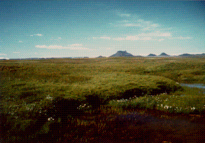
Beginning of Kjöur route: last patches of green stained with
"cotton"
flowers before the desert prevails, Langjökull is visible on the
horizon.
The landscape changes really abruptly, no more green
bush, only earth and stones, the road is anymore paved, but the well
pressed earth surface lets our wheels roll more easily than the rough
Icelandic asphalt does. The road temporarily leaves the main
Hvítá river valley climbing to the pass between
Bláfell mountain and Langjökull. That's, in my memory, the
most scenic part of the journey: the contrast between desert and ice,
under a deep blue sky, is really an unforgettable feeling.
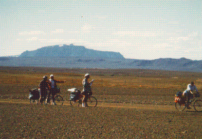
A quick look at the map while the landscape has already turned
into desert, Bláfell mountain in the background.
Left to right: Federico, Sebastiano, Davide and Giovanna.
The climb
to the pass, about 25 km from Gullfoss, doesn't give rise to any
difficulty, apart from a short and steep slope, just after a river
crossing, which requires my 28 teeth chainwheel. After the pass the
road descends peacefully back in the main valley towards the
Hvítarvátn lake, renowned for the icebergs released in
it by a Langjökull's tongue. Just after crossing the river below
Hvítarvátn we leave the main road and we take the
deviation on the left which leads to Hvítarnes hut where
there's also a camping facility. In the hut a kind group of
-motorized- Germans offer us the leftovers of their dinner, which
constitute a welcome gift for our ever-hungry stomachs.
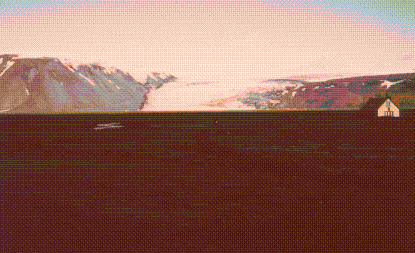
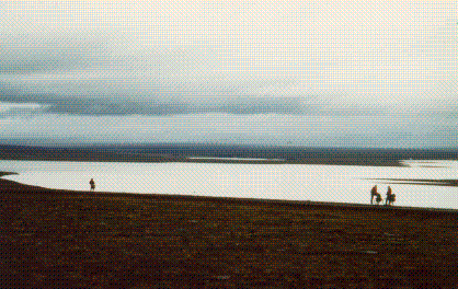
The relaxing appearance of Hvítarnes in the evening,
Hvítarvátn lake is hardly visible below the glacier.
Hvítarnes-Hveravellir 51 km.
The following day we take the official photo of the tour and we
exchange some words with the man at the campsite (helped by his
daughter in translating from English to Icelandic) about glacial ages
and the extent of the glacier at our back in the past centuries, just
before leaving for the leg that was going to be the toughest in our
tour. After a few minutes our riding is interrupted by a river, we
discover in fact that the road which leads from Hvítarnes back
to the main Kjölur route northwards is unbridged, so we have to
take off our shoes and load the bikes on our shoulders in order to
ford the river, not so terrible anyway.
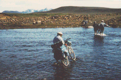
River fording near Hvítarnes, Kerlingarfjöll mountains
with
their glaciers can be seen in the background.
Left to right: Riccardo, Federico and Davide.
The sun keeps on shining
brightly while some wonderful multi-layered clouds appear in the sky,
but we soon realize that the road is getting worse: we encounter many
series of potholes with a 40 cm wavelength which are impossible to
ride over, so that we have to look continuously for the best trail at
the center or at one side of the road, moreover we are on a bank
holiday so, believe it or not, the road gets crowded of cars, of
course no relation to the jams we are used to ride in on continental
Europe, but a bit annoying on a gravel road. But, of course, the
colors and the shapes of Iceland compensate these disadvantages, so,
after a long pedaling we manage to cover the 55 kilometers between
Hvítarnes and Hveravellir where we are hosted by a friend of
us, Sigurður, an Icelandic meteorologist, who is working for a
couple of months in the local weather station and stays there with his
wife and his sons.
Hveravellir-Blöndulón-Friðmundarvótn 60
km.
After a morning bath in the hot spring next to the camping we say
hello to our friends and we leave Hveravellir with less confidence
than in the previous days because of the changing weather. The sky is
getting very cloudy and the glaciers are hardly visible, however the
wind is in our backs so we keep on going further. The road gets better
than the previous day, much less potholes, but the surface is softer
than before so it takes a little more effort to proceed. The rain
starts falling in the early afternoon but we continue until we find,
about 30 km away from Hveravellir, the first sign of 'civilisation': a
fishing lodge which offers also coffee and snacks, so we avail
ourselves of this chance then, when we get out, the rain has almost
stopped falling and after a short and steep climb we enjoy a
magnificent view over Blöndulón lake which looks like
quicksilver under the grey cloudy sky. A fast, slightly downhill,
stretch of Kjölur route brings us to a few interesting zone
surrounded by lakes where we decide to put our tents after our daily
50 kilometers.
Giovanna, Sebastiano, Federico and their bikes standing out against
silver
Blöndulón after a recent rain.
Friðmundarvótn-Bólstaðarhlíð-Varmahlíð
51 km.
Our last day of Kjölur route starts with the previous fast gravel
road which brings us to a very steep paved descent, close to a
hydroelectric power plant, leading to the bottom of the valley. From
here the road, unpaved again, but no longer called Kjölur route,
keeps going along this pleasant valley for 15 km before reaching the
-paved- main ring road #1 leading to Akureyri in
Bólstaðarhlíð. A never ending climb and the
subsequent downhill adding to 24 km bring us in Varmahlíð
and a comfortable bus (we haven't enough holidays to make it all by
bike) brings us to Akureyri, 80 km further on.
Some technical notes
This itinerary is not so harmful as it may seem for the bike
components if you ride carefully (few big stones, no sand, but this
doesn't hold for other Icelandic interior roads) so an ordinary MTB
could be enough, just be sure to bring with you all the tools and
spare parts you may need 200 km away from the nearest bike shop
(however there's a bus to Akureyri once a day in case you have to give
up) and check the strength and stability of your rear rack, that's, in
my opinion, the part of the bike which gets more stressed due to the
load you have to bring.
I thank my friends Federico, Giovanna, Riccardo and Sebastiano for
having made the dream of crossing Iceland by bike become reality
together with me. A big thank also to Cavazza and Suzzi, two of the
best bike mechanics and assemblers in Bologna who supplied some of the
bikes and many good advices.
