We dodged trolley buses and rode past the Bourbaki Panorama, where battlefield models with mural backdrops depict scenes from the French-German war of 1871. The Panorama and the adjacent sculpture of the Lucerne Lion in honor of the Swiss that died in that war. This monument is adjacent to the Glacier Garden with interesting stone formations from the ice age and is worth a visit.
http://www.bigfoto.com/Sites/galery/switzerland/luzern_loewenwdenkmal.jpg
We stopped at the train station plaza to photograph the definitive postcard scene of Lucerne -- the covered wooden bridge over the Reuss decorated with flower boxes, graceful swans swimming on the river and the Pilatus Mountain as a backdrop. Today the Pilatus remained shrouded in clouds. We arrived in time to see the flock of Alpine Swifts, one of the fastest flying birds, make their warm-up laps around the bridge tower before departing to the mountains for a day of aerial foraging.
http://www.bigfoto.com/Sites/galery/switzerland/switzerland_003_luzern.jpg
http://home.tiscalinet.ch/jud.zwahlen/lu/lutour.htm
http://www.picswiss.ch/Luzern/LU-l7-08.html
We gave the Pilatus cogwheel railway, the world's steepest (48% grade), a quick inspection before continuing to Sarnen, where we turned off to Flüeli-Ranft and the Melchtal. We took the small road past the train station and crossed over the meter gauge adhesion and cogwheel Brünig Swiss Federal Railway, known as the SBB, CFF, or FFS, depending on the regional language. Beyond the tracks we passed a classic Schützenhaus (rifle range house) with carved wooden beams and decorative flower boxes. This little-used road then climbed a limestone wall into a small forest of alder on the way to Flüeli.In Flüeli, we passed the large hotels of this pilgrimage town and the log cabin of ascetic Bruder Klaus. The cabin looks like a replica and contains all his belongings, nothing but a Bible and a few prayer books. It is said he used a stone for a pillow as he slept on wood planks. The faithful are not bothered by any of this and on occasion flock there by the busload.
It's still a little climb past Ranft on a road that looks more like a driveway to some upper residences. We passed a NO VEHICLES sign at the edge of a forest along the steep slopes above the cascading Melch. After a gradual climb on this paved forest road, we crossed a covered bridge to join the main road that climbs to the end of this box canyon.
We stopped for lunch at a Gasthaus in the town of Melchtal before continuing to Stockalp (1075m) at the end of the valley. Here, a narrow road with hourly one-way traffic climbs seven kilometers at a 12% grade to the small ski area of Frut (1891m). At bicycle speeds, this climb can take longer than an hour, but because the road is wide enough for cars to pass with care, timing is not a problem for bicycles. The road is framed by steep overhanging cliffs as it makes its hairpin turns up to Frut on the Melchsee.
Beyond the Melchsee, a short climb across the back of a dam took us to the Tannensee (1976m), which had no snow or ice on it, as it had in other years. The road ends in Tannen, just beyond the lake, at a large hostel next to a diary and some vacation cottages. We took a narrow hiking trail along cliffs above the Gental to Engstelnalp (1834m). Here a paved restricted access road descends the Gental to the Gadmental and the Susten Pass highway, which we took down to the Haslital at Inertkirchen (625m).
http://www.paloaltobicycles.com/alps_photos/s87.html
http://www.aareschlucht.ch/englisch.htm
http://www.evo.org/sherlock/europe/reichenbach_falls.html
A new Hotel Zwirgi was taking shape at the junction with the road from Meiringen where last year only an enlarged parking lot remained after the old hotel burned to the ground. The climb to Rosenlaui is fairly steep as it climbs past Hotel Kaltenbach before finally leveling off in the Rosenlaui Valley. We got glimpses of the Rosenlaui Glacier through gaps in the clouds as we approached Hotel Rosenlaui (1330m). The hotel was abuzz with guests, leaving us little chance to talk to Andrea and Christina Kehrli, the proprietors. With the 5th floor dormitories full, we took a comfortable room where we got a good night's rest after a hearty dinner with 58cl (Swiss standard size) Eichhof beer and Coup Dänemark dessert.http://www.alles-fahrbar.de/alte_homepage/Mountain2002/17bild.htm
http://www.paloaltobicycles.com/alps_photos/s84.html
Above tree line, a light drizzle started and gradually turned into solid rain, shrouding even the lower slopes of the Wetterhorn (3701m) with its glaciers and icefalls. As we began our descent from the Große Scheidegg summit (1961m), only the lower parts of the Eiger were visible but we mentally filled in the rest of the scene -- the dark Eiger (3970m), the Mönch (4099m), and the pure white Jungfrau (4158m).We returned to the public road in Grindelwald (1034m), where the Berner Oberlandbahn (BOB), meter gauge adhesion and cogwheel railway was unloading passengers from Interlaken, and where the Wengeralpbahn (WAB), 800mm gauge cogwheel train takes them up to the Kleine Scheidegg (2016m) to connect with the famed meter gauge cogwheel Jungfrau Bahn that tunnels inside the Eiger to the saddle at Jungfraujoch (3454m). These three railways use respectively Riggenbach, Abt, and Strub cogwheel drive from the days when these designs were in competition as the latest advances in railway technology.
We cruised through town and down the valley, following the cascading Schwarze Luetschine that joins the Weisse Luetschine from Lauterbrunnen at Zweiluetschinen. Crossing the river on bridges engulfed in icy fog was like passing the open door of a deep-freezer. We reached flatland at Wilderswil, where the Schynige -Platte-Bahn (SPB), 800mm gauge cogwheel train climbs to the Schynige Platte (2061m) for a panorama of the Jungfrau group that is too close to appreciate from Grindelwald. With the poor weather, not much was happening here today.
In Interlaken (563m) we looked across the large meadow in the middle of town for the usual view of the Jungfrau but alas, saw only clouds. We crossed the Aar River and rode along the north shore of the Brienzersee to Brienz, a small town in a narrows between the cliffs of the mountain and the deep blue lake. Here the steam powered Brienzer Rothornbahn (BRB), 800mm Abt cogwheel railway climbs through tunnels in rugged cliffs to the top of the Brienzer Rothorn (2353m). The pungent smell of coal smoke from one of the locomotives wafted across the road as we passed.
http://digilander.iol.it/zh/cograilways/brienzer.html
In Meiringen, the home of meringue, we passed Sherlock Holmes, in life-sized bronze, with pipe, cape, and deerstalker cap sitting in the middle of town. From here we rode through Willigen on our way up the Kirchet (709m), where we stopped at the Lammi restaurant for lunch. Our "sun shade" umbrella kept some drops off our table as we ate a good lunch of Schüblig and Rösti with a green salad and a tall cool beer.The climb up the Haslital to the Grimsel Pass has two reprieves, one in Guttannen, where there is a good grocery store, and another at Handegg (1402m), where there are accommodations in case of foul weather. The road continues between granite walls to huge concrete dams of the Kraftwerke Oberhhasli (KWO) hydroelectric system, which is accessed by giant aerial trams in winter.
http://www.paloaltobicycles.com/alps_photos/s90.html
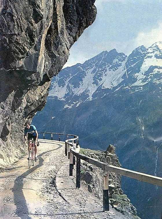
The road enters a one-kilometer tunnel above Handegg where bicyclists must take the old cobblestone road, notched into the granite wall high above the Aar. It was drizzling again by the time we emerged from under the cliffs to rejoin the main road. The mighty Finsteraarhorn (4275m), tallest peak in the Bernese Alps, was shrouded in fog with only the noses of the Unteraar and Oberaar Glaciers at its base visible through the mist. We reached the Grimsel summit (2165m) in thick fog, and Richard suggested that the hotel Grimselblick on the Grimsel Lake might be a good place to stop since the weather was only getting worse. However, looking through the gap beyond the lake, we discovered that the Rhone Valley was bathed in sunlight with a clear view to the Furka Pass above the Hotel Belvedere and Rhone Glacier. The warmth of the Rhone Valley was more inviting than the weather behind us, which although cold gave us the benefit of little traffic. Beyond the Furka Pass, a solid cloud bank promised more rain for tomorrow.http://www.paloaltobicycles.com/alps_photos/s67.html
We descended a series of hairpin turns to Gletsch (1761m), directly below in the Rhone Valley, and crossed the tracks of the Dampfbahn Furka-Bergstrecke (DFB) Railway. After inspecting their new turntable, we started up the Furka. We posed for the obligatory picture in front of the glacier, just below the Belvedere (2272m). Although the hotel was inviting, we chose not to stay fearing that we could get stuck there by bad weather. The Furka Pass (2431m), 266m higher than the Grimsel, lies in the gap at the head of this bare valley, swept clean except for some shrubs, by winter avalanches. From the Furka, we looked back at the Grimsel where fog was pouring over the summit and down into Gletsch.http://www.furka-bergstrecke.ch/
We crossed the Furka summit and coasted through Tiefenbach and Galenstock on the long gradual descent to Realp (1538m). Although there was activity at the DFB engine house, we didn't stop, but continued into a light headwind to Hospental (1452m) at the junction of the Gotthard and Furka Pass roads. As usual, we found a good dinner and lodging at Hotel Rössli where we were welcomed as "regulars".I posed for Richard to take my picture at the Gotthard summit (2108m) sign next to the lake as I had on my first tour over 40 years ago. From the new road, we admired the serpentine curves of the old road below in the Val Tremola before entering the long tunnel that emerges high above the Val Bedretto on a flying hairpin, 520m above Fontana. Farther down, at the Fortezza (1551m), bicycles must take the old ROUGH road of 10cm grey granite paving cubes whose center stripe is made of orange granite cubes. Pavement is especially bad in curves because the stones have tilted from side forces. The road levels off and returns to smooth pavement in Airolo (1165m), the south portal of the Gotthard railway and highway tunnels.
http://www.paloaltobicycles.com/alps_photos/s04a.html
http://www.paloaltobicycles.com/alps_photos/s01A.html
http://www.ub-feuerwehr.de/02/02/020209.htm
I found it amazing that the railway, which carried trucks and cars before the highway tunnel was built, does not offer a more economical alternative to waiting one or more hours to drive under the mountain. At Ambri a funicular railway, the world's steepest federal railway, connects a large SBB hydroelectric plant with its reservoir, the Lago di Ritom.http://mikeaz.free.fr/suisse/piotta01.htm
At the end of the Rodi-Fiesso Valley we descended from Rodi (925m) to Faido (711m), while trains, some with distinctive freight and international passenger cars, passed us in both directions on the adjacent doubletrack Gotthard railway. "Hey, haven't we seen that train somewhere before?" Indeed we had, as the trains were using two corkscrew loop tunnels to lose or gain altitude on the steep mountain slope.We passed two more circular tunnels at Anzonico and then rolled into the wide and level valley just above Bodio (322m), the south portal of a new 52km Gotthard railway Tunnel, which is being built to get international trucks off Swiss highways. After taking pictures of tunneling machinery and the crossing waterfalls in Biasca, we continued to Bellinzona (239m).
The sun hadn't made an appearance yet and from what we saw, it wasn't going to. We headed south through Giubiasco and on to Cadenazzo, where most traffic heads south over the Monte Ceneri Pass (559m) to Milano. Shortly beyond, at Quartino, most remaining traffic heads off toward Locarno on the west shore of Lago Maggiore. We stayed on the east shore, stopping in San Nazzaro for lunch. This time we ate indoors because rain seemed imminent. After a delicious meal the rain came, just as we pushed off toward the Italian border at Zenna where no one noted our passing, as is the norm for the EU.
By the time we got to Luino, the road had puddles with plenty of splash. We picked up some euros from the same bancomat that had previously given us lira. From Luino we rode along the lake in a series of tunnels and slide protection galleries and then climbed over a hill to Laveno. We took the ferry across the lake and landed in Verbania, on the fancier western shore with its famous resorts.
We followed the Toce River, which flows from the San Giacomo Pass to Lago Maggiore, and rode around the Toce estuary to Fondo where we crossed the river to Gravellona and climbed a short hill to Omegna (298m). We passed weekend resorts and old villas along the east shore of Lago d'Orta and got a good view of La basilica di San Giulio, a monastery in the midst of a dense cluster of buildings on San Giulio island.
At the south end of the lake at Gozzano (367m) our road along the hills was closed for pipeline construction, but we were able to get through, there being no activity due to wet weather. Climbing a short steep hill got us to Pogno (461m), where the four-spigot fountain on the piazza came in handy even in the rain. We climbed west up a canyon in a blooming chestnut forest, typical of the southern slope of the Alps, and broke through the ridge at an unexpected tunnel (598m). From here it was a straight descent to Borgosesia (359m).We crossed the high stone arch bridge over the Sesia, which was a muddy torrent rushing through its open flood gates. In other times it has been an azure lake with black swans and huge trout in the deep clear waters.
Richard had begun to cough and wheeze earlier in the day, but was now rapidly getting worse. We continued up to Gaggiola, where we found a small but comfortable hotel and had a delicious dinner. Richard had a fitful night and felt weak and tired in the morning.
At Palazzo Canavese (492m) Richard called our bicycling friend Brian Tomlin in Ivrea for a ride, while I rode over the ridge and descended to Ivrea (245m). It began to rain as I crossed the bridge over the Dora Baltea in the center of town. I phoned Brian, who said he was only a few hundred meters away and that I should follow him to his place, there being no room in his car for my bicycle.
At Brian's place we showered, put on dry clothes, and ate well, benefiting from Brian's skills as an Anglo-Italian chef. I got a lot of sleep on the sofa between lunch and dinner while Richard survived in a spare "isolation" bedroom with his horrible cough. He obviously could not continue and, as it turned out, stayed another day before taking the train back to Switzerland where he took several days to get back on his feet.
http://www.leksykony.pl/zamki/wlochy/racconigi.html
With cool still air, the ride to Cuneo was a breeze, so to speak. Near Cuneo, the road turns west along the north bank of the Stura di Demonte, where a beautifully restored bi-level stone arch bridge carries road and railway high above the river. This time there were plenty of delicious tart Japanese plums on the street trees near the bridge.I took a right just after the bridge and stopped for a good drink from the huge fountain in front of the train station. Then I continued to Borgo San Dalmazzo, where the Tenda Highway (SS20) turns south to Robilante, and the SS21 heads west to the Col de Larche and France. I stopped in Robilante to say hello to Eliano Giordanengo at the chainsaw store. He has hundreds of new and used chain saws stacked in tiers in the catacombs of his building that looks no different than others on the piazza.
Fortunately the Ristorante-Albergo Aquila Riale, one of my favorite stops, was not closed on Wednesdays as it had been the past two years, so I enjoyed their hospitality.
At 1279m the road enters the 3180m-long Tenda highway tunnel, which was completed in its present form in 1882. A sign with the "bicycles prohibited" icon stands at the tunnel portal, across from a small shop with refreshments and a good selection of local maps. Meanwhile, the old Tenda road, looking like a hotel driveway, takes off across the street.20
This road had recently been repaved with smooth asphalt to the Tenda summit (1908m) where the view exposes a panorama greater than the altitude might suggest. Not only is the summit a national border but it seems to be a 100-year step back to a time before paved roads and comfortable hotels. Pavement ends here and baseball-sized gravel begins on the 19th century road of the south side. Partially collapsed stone roadhouses, that served travelers before the tunnel was built, lie along the road, while huge empty fortifications stand guard on the ridges above as sentinels of history.
http://www.paloaltobicycles.com/alps_photos/f64.html
Sixty or so hairpin turns descend steeply into the ravine of the Roya River. Many of the loose and deeply rutted turns are tough going even for a jeep. Although some curves had been paved with asphalt, most of it was gone by now, washed away by the rains that had damaged the highway below. Historic photographs of mule and horse teams, steam tractors, and solid-tired chain-driven trucks that once traveled this road make today's "hardships" pale in comparison.http://www.paloaltobicycles.com/alps_photos/f89.html
I rode more carefully than usual because the deeply rutted turns defied crossing if taken on the wrong side of the road. Below, in the rocky gorge of the Roya River, I finally left the gravel and got on the swift smooth curves of the Tende highway, French Rt N204, where it emerges from the tunnel (1279m).The railway emerges from its tunnel at Vievola (990m), only to vanish into a loop tunnel followed by many bridges as it descends to Tende (816m). The road gradient is about 8% here so it is not difficult to keep a good pace down into the Soarge Gorge. The road to the town of Soarge heads into a tunnel, and few windows reveal its route in the canyon wall as it climbs to Soarge, a strip of houses glued to the cliffs, some with more than a hundred meter freefall from their windows.
http://www.voyageenfrance.com/image/ville/viewer.php3?&nomfic=6/grand/25.jpg&departement=6&file=25&suivant=0
http://tinyurl.com/k8b7
The descent is pleasantly gradual to Sospel (349m), the junction of the Brauis, Braus, and Turini passes. I took a picture of the old stone arch bridge and its collage of buildings over the Bevera River, reminiscent of the Ponte Vecchio in Florence. It was warm enough for a stop at the ice cream store and deli where the proprietor, my favorite small town philosopher, presides. I got a sandwich and dish of ice cream while he settled down to lunch with his family. Over the years, he has greeted us as though we were regulars although visits are only once per year.
Instead of heading north up the valley on Rt D70 to the Turini Pass (1607m) of Monte Carlo Automobile Rallye fame, I took the road to the Col de Braus (1002m), a low pass with a tunnel at the summit. Before the tunnel I headed west along the ridge on a small road that heads toward Piera Cave, a small hill town where I have stopped for the day years ago. The road was as empty as ever and showed little signs of use except for the ABS brake skid marks entering some sharper turns. I suspect that some drivers were trying to emulate the great racers of the Monte Carlo Rallye.
After a long gradual descent, I climbed a series of hairpin turns to Piera Cava (1450m), where the road briefly levels off before climbing to the Col de Turini (1607m). This looked OK until I reached the summit, where the sky suddenly opened with buckets of rain while lightning struck nearby. Waiting didn't seem reasonable, so I headed downhill. About two-thirds of the way down, at the overlook above La Bollene-Vesubie, the rain stopped and I took a photo of this beautiful mountain village on a knoll with shade trees and houses clustered around a church, an island rising above a green backdrop.
I descended to Rt D2565 on the Vesubie (520m) and climbed the gradual grade to St. Martin Vesubie (930m), a pleasant town lying at the foot of the narrows leading to Col St. Martin (1500m). I stayed at what was called the Hotel Les Tres Ponts but is now the Hotel Le Gelas. Although under new management, it seems to be as good as ever. The steep and narrow village street in front of the hotel has a gargouille down its center, a stone sluice that gurgles with running water all day and serves as a drain when the street is cleaned by flooding at night.http://www.provencebeyond.com/villphotos2/stmartinP1.html
Beyond the summit, I descended westward, first through a large grassy ski area, and then into dry sparse vegetation in the red rocky gorge of the Tinée River.
http://www.fortunecity.com/greenfield/macdonalds/296/a/a1/avionroquero.htm
Across the canyon, roads that are tiring just to look at follow tortuous paths up through cliffs to mountain villages like Ilonse (1200m). I crossed the Tinée, heading westward on Rt D30, and climbed past the ancient village of Rubion on the way over the Col de la Couillole (1678m). Then I descended to Beuil (1450m) and climbed to Croix de Valberg (1829m).http://www.provencebeyond.com/villages/roubion.html
I took the "back" road down to Guillaumes (1200m) and headed up Rt N2202 along the Var River in the Gorges de Daluis toward the Col de la Cayolle (2327m). This area has special appeal for me because most of it lies in a national park with no ski areas and accompanying development, offering only villages with simple accommodations. The Cayolle is also the first 2000m pass I rode over on my 1960 tour and remains unchanged. The summit is set in the midst of steep alpine meadows covered with wildflowers and has nothing more than a narrow parking strip along the road.I descended through the Gorges du Bachelard along the Torrente Bachelard to Barcelonette (1000m) and was happy to find that the tailwind I had all day would last for the run from Barcelonette up the Ubey River to Condamine. Here, I stayed at the Hotel du Midi, as I have on many tours beginning in 1960. Just above town, the mountain is riddled with tunnels from the valley floor to cliffs above, where huge fortifications keep a silent vigil for enemies long gone. Only bullet holes in the buildings remain as combat mementos.
As I climbed I noticed that landslides had steepened some sections and flattened others. With the road covered with droppings for the last few kilometers, I was lucky that the usual flock of sheep had already made its trek up the road from the valley and was now grazing next to the road. My experience has been that sheep herds on the road are impenetrable without intercession from the shepherd and his motley dog. And you must wait for the shepherd to decide where the right place is.
At the summit the ramshackle corrugated steel shed, that I first saw in 1960, had collapsed during the winter and not been repaired. The old folks who had offered postcards, maps, sodas, and coffee there all these years may have decided it was time to quit.
On the descent to Guillestre (1136m), I could make out the gap of the Galibier Pass, where I was headed, in a distant panorama of snowy peaks and glaciers above the Durance Valley. I stayed on the Route des Grand Alpes (D902) instead of taking the main route (N94) up the valley to Briancon. My road followed the rugged gorge of the Guil River and turned up the Riviere canyon where it met the Passo Agnello route (D947). It was easy going up to Arvieux, where I stopped for lunch at the grocery store. Across the street from the store, an alcove under the city hall with a bench, water fountain, and public restroom, served as my lunch room.
Although lunch was satisfying, the weather was not. My pleasant following breeze turned into a stiff headwind as I started up a straight steep section from Arvieux past Brunnisard on the way to the Col d'Izoard. The going got easier above Brunnisard, where the grade eased while the road went into traverses and hairpin turns that gave shelter from the wind. At the false summit I could see the rest of the climb across the canyon, zig-zagging to the obelisk that marks the summit. With a short descent and a bit of climbing, I arrived at the Coppi memorial where a bronze caricature of Fausto is mounted on a marble plaque. This treeless landscape looks like the moon, with vast slopes of dark grey scree at the angle of repose. The exposure makes this climb especially difficult in warm weather.
http://www.paloaltobicycles.com/alps_photos/f72.html
From the Izoard (2361m), the gap of the Galibier Pass was again visible in the distance. Descending the unspectacular road, I arrived in Briancon (1391m), a large town overrun with tourists and traffic, where I took Rt N91 (also D902) with its gentle slope of 2% to 4% to the Col du Lautaret (2058m). A headwind made it seem steeper than in times past.On the Lautaret, the new Hotel des Glaciers, now known as Hotel Bonnabel, was splendidly built after the old hotel burned three years ago. The new hotel was designed around the grand dining room and centerpiece of grandfather Bonnabel's unfinished project. I was glad to meet Paul Bonnabel, who ran the hotel before his nephew Dominique took over, and had a long chat with him about old times. After an elegant dinner I retired to a split level room that was one of the least expensive, but still excessively posh for bicycle touring. It made me think adieu Hotel des Glaciers and the simpler days of yore.
http://www.hotel-bonnabel.com/
http://www.memoire-du-cyclisme.com/dossiers/dos_1911_1.php
http://www.paloaltobicycles.com/alps_photos/f30.html
Descending many hairpin turns of the Telegraph through a thin larch forest went slowly in the wet. In St. Michel I got on the main route from Torino to Chambery, served by Rt N6, Motorway N6, and a doubletrack rail line. I rode up Rt N6 which is still under siege as the motorway is being bored through adjacent canyon walls for greater truck traffic to the 12.9km Frejus highway tunnel to Torino. Meanwhile a base railway tunnel has been started to undercut all of these efforts. The gradual climb, which goes in fits and jerks, helped warm me up on the way to Modane, the south portal of the Frejus Railway Tunnel.
Above Modane (1057m), after most traffic took the highway tunnel, I climbed a pleasantly empty road that rises above Avrieux, the site of subsonic to hypersonic wind tunnels, located here after WWII because hydropower was abundant. Above Avrieux the road levels off next to a deep defile of the Arc River, a natural obstacle guarded by a huge fortress. Tourists cross the breathtaking gorge to the fort on the Pont du Diable, a slender truss foot bridge that accentuates the depth of the chasm. Beyond the gorge, I descended to the valley floor and rolled gradually up to Termignon (1300m). From here, it's a short climb up the valley to Lanslebourg (1399m), the foot of the Col du Mont Cenis (2083m), which heads south to Torino. I stopped for a restaurant lunch in Lanslevillard, the upper end of Lanslebourg.
After Lanslebourg an unexpected steep climb to the Col du Madeleine (1746m) sneaks up on the casual map reader. From the col, the road dips into the high valley of the Arc, an alpine paradise of steep walls, towering crags, and remote side valleys that expose the huge glaciers of the Croce Rossa (3526m), Via del Ciamarella (3676m), and Albaron (3627m). At the head of the flat valley, I rode through Bonneval sur Arc (1835m) and took the big sweeping turn that begins the main climb to the Iseran Pass.
I traversed the steep slope to reach the Gorge de la Lenta and climbed the east wall of the gorge over waterfalls and through bare rock tunnels. Near the top of the cliff, the Lenta cascades into the gorge through a slot. A short way beyond the lip of the gorge, the road crosses the river on a stone bridge and takes two long traverses to reach the summit. Here I was rewarded with a panorama of the entire climb backed by snow-capped peaks.
After a photo stop at the large concrete sign at the summit, I put on my jacket and descended to Val d'Isere where I ran into heavy rain. At Ste. Foy-Tarentaise the rain stopped, and I continued descending to Seez, at the junction with Rt N90, the road to Col du Petit St. Bernard road.
I found no rooms in either of the two hotels where I usually stay in Seez and continued down to Bourg St. Maurice where the situation wasn't much better. After I had tried a couple of hotels, the lady in one hotel suggested, "Go back to the hotel across the way. I'm sure they have something left, though perhaps not a single room." I did that and took a double room in the Hotel SARL, just as more people arrived to find nothing left.
At dinner I noticed a side dining room full of American bicyclists whose tour leader told me that they were from New Hampshire. He told me that the whole town was overrun with bicyclists who planned to ride a stage of the Tour de France tomorrow, the day before the race would take the same route. He estimated that there were more than 7000 bicyclists participating, something that became more believable the next day.
Soon a police car, with blue lights flashing and its famous two-tone klaxon blasting away, went by, and then... for the next hour, bicyclists came up the road wall-to-wall, wheel-on-wheel. This got dull after an hour, so I sized up the action and when riders of my speed began to pass, I hopped in. As it turned out, not soon enough. Farther up, hairpin turns slowed the column to stalling speed so everyone walked the next 200 or so meters. The next time this happened I saw that I could cut across the steep meadow and pass more than a hundred riders to get to clearer air, so to speak.
The riders up front were a bit swifter and didn't stall on curves. I talked to some of them but their preoccupation with technique and strategy was too serious for me. Fortunately, I had planned to turn off at les Chapieux (1552m), half way up the Cormet de Roselend. From the junction I could see the road high above clinging to the ledges and carrying a stream of bicyclists.
From les Chapieux, a little used road heads into the Vallee des Glaciers to Ville des Glaciers (1781m), from which the trail to the Col de la Seigne crosses the river to a pack station with donkeys and a small restaurant with hot food. I got a snack and then ambled up the path, which in places was steep enough to require carrying, rather than pushing or pulling the bicycle. Unlike two years ago, when I did this with John Woodfill in the snow, today was a beautiful breezy day with puffs of clouds. All the while the various peaks of Mont Blanc with large glaciers rose above the ridges ahead.
The summit of the Col de la Seigne (2516m) was marked by a stone pedestal with a large engraved bronze disk identifying the various peaks and their elevations. I rode down most of the rocky trail that appears to get more traffic than the side I came up. Although fatter tires would have been welcome for the rough stuff, I managed to reach pavement at la Visaille in the Vallee Veneay without a flat. I stopped for a hot lunch at a restaurant with an outdoor deck.
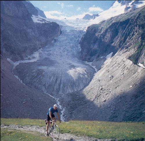
/Bike/Countries/Europe/Tour_Reports/Tour_of_the_Alps/Gallery/glacier.jpg
I descended steeply to Entreves (1380m), above Courmayeur, the entrance to the Mt. Blanc tunnel, and then climbed an equally steep grade up the Val Ferret. The road leveled off after a bit, but to make up for the lesser grade, it soon ran out of pavement. I stopped at Refuge Elena (2062) at the end of the road, opposite the Glacier de Triolet, for food and drink before picking up my bicycle to scale the Grand Col Ferret from the steep side. I hadn't tried both Col de la Seigne and Grand Col Ferret on the same day before, and the steepness of the trail impressed me this time. Much of the ascent required carrying the bicycle, but to make up for that, the green meadows with wildflowers under a sunny sky over Mont Blanc made it hard to complain.
http://perso.wanadoo.fr/cyclotourisme.aubenas.vals/ferr/previewpages/previewpage8.htm
http://tinyurl.com/k8az
http://perso.wanadoo.fr/cyclotourisme.aubenas.vals/ferr/previewpages/previewpage18.htm
http://tinyurl.com/k8b2
I rode through the curved Schallberg tunnel to reach level ground in the Gantertal, high above the Saltina, the river that flows through Brig. The Saltina flooded on 24 September 1993, putting most of the town under as much as two meters of water and gravel. About a kilometer farther, a high concrete suspension bridge crosses the Gantertal to Berisal (1520m).
http://www.brueckenweb.de/Datenbank/Suche/brueckenblatt1.php3?brueckennummer=314
http://tinyurl.com/k8at
http://www.picswiss.ch/Land10/VS-10-05.html Today was a no-traffic day as I swept down into the galleries along the granite walls of the Gondo gorge, high above the Diveria River in the Val Divedro. After a long zigzag down the wall, I rode through Gabi and Gondo, where I could still see severe damage from the landslides in October 2000. At Iselle (672m) the 20km Simplon railway tunnel emerges from its south portal to vanish again into a tunnel that makes a loop in the mountain to lose elevation. The bridge over a creek before Varzo (532m) was still washed out from the floods of several years ago and may not be rebuilt because a bypass around the whole town is being built over the Diveria. The detour over a bumpy temporary bridge is so slow that we can no longer swoop across the creek and sprint uphill to the Varzo city limit.
http://www.paloaltobicycles.com/alps_photos/s25.html
About a kilometer above Crevoladossola (337m), which lies at the end of the narrow part of the canyon, the highway enters an autos-only tunnel where bicycles must (and prefer to) take the old road into town. I took a picture of the graceful and ancient stone arch bridge before Crevoladossola, where I turned east into the Val Antigorio through Crodo (the home of Crodo Acqua Minerale) and on to Baceno (655m) at the confluence of the Toce and Devero rivers. As I looked for a hotel in Baceno, screaming Swifts made their last fast laps around town in what looked like a super fast bicycle criterium, emitting high pitched screams as they flew. Swifts always scream when they are having fun.Now and then, after sounding sirens three times, one of the quarries would set off a blast with a deafening echo. If well executed, a block as big as a dumpster separated from the cliff with nothing more than a tell-tail whiff of white dust. As I rode up, trucks nearly as wide as the road crawled down, their compression brakes roaring, carrying their blocks to factories to be cut and finished for building materials.
Besides granite quarrying, hydropower is the big industry here. I was not lucky enough to be here on Sunday or Thursday afternoon, when the Toce River flows down the Val Formazza instead of in penstocks to an Ente Nazionale per l'Energia Elettrica (ENEL) power plant. At the head of the valley I could see only a trickle instead of the 143m Cascata del Toce that draws huge crowds on weekends. I climbed under the zigzag avalanche shed up the wall to the l'Albergo Cascata del Toce (1675m) that stands at the edge of the waterfall.
http://www.itinera2000.org/tedesco/walserted/doc/walserted-117.htm
Surprisingly, the 2003 Giro d'Italia will have a stage finish at the top of the falls. A first for the Val Antigorio.19th Stage, Friday 30 May CANELLI - CASCATA DEL TOCE (236km). The last 18.3 km climb to the finish atop the falls.
Above the Hotel Cascata del Toce di Riale, at La Frua (1681m), the road climbs gradually to the small village of Riale (1728m), where the road to the San Giacomo Pass turns off to the right in the Valle di Morasco to start its climb up the south wall. This unpaved road is well graded in times of use by ENEL, which this was not. Navigating the rough surface exposed by recent heavy rains required walking in rocky sections where streams ran down the road, whereas other sections could be ridden easily. The solitude and striking landscape make this one of the great roads in the Alps.
http://www.paloaltobicycles.com/alps_photos/i54.html
http://www.paloaltobicycles.com/alps_photos/i35.html
This time I took the main trail marked on my map that descended to a knoll from which I saw a substantial cow shed with attached residence below at the edge of a meadow. Thinking that there must be a road to supply this facility, I continued, only to discover that it was a former military building that had been built by helicopter. There was no road and the cows that I saw had come over the pass just as I had. There was no way down the mountain other than the well-marked but precipitous trail through which no cow could pass.
The farther I descended, the more difficult the trail got, passing between huge boulders overgrown with juniper, alpenrosen, and larch trees. A hiker coming up warned me that the trail got worse. Worse? She was right. The trail was so impassable for me with my bicycle that I had to bushwhack an alternate path around some sections. The trail did not improve until reaching the bottom, in the Val Bedretto, where I discovered that my saddlebag holder had bent and had nearly separated from the saddle from all the bouncing on trails yesterday and the drop-offs over boulders today.
Once on the road (1814m) I coasted down to Airolo and on down the Valle Laventina on Rt N2 hoping my saddlebag would not fall off. In Biasca I found a first-class bicycle shop with all that I needed to repair my bag holder.
I turned east at Castione (242m), up the Val Mesolcina, on the road to the San Bernardino Pass (Rt 21). The road was nearly flat up the valley to Soazza, where it climbs smartly to Mesocco (790m), the former terminus of the abandoned Rhätische Bahn (RhB) Railway from Bellinzona. This line was once planned to cross the mountains into the Rhine Valley to join the rest of the RhB network.
I stopped by Ristorante Beer in Mesocco where the same host has presided for as many years as I can remember. He is notable for his ability to recite complex menus from memory and to keep in his head what every guest ordered without notes. Unfortunately for the second year in a row I arrived on Wednesday, the day off, and had to go up the road to the place where I stayed last year.
After a snack at the store, I rode up the most scenic part of this climb through glacial formations, with running water and green meadows of wildflowers, bog cotton, and alpenrosen. Remnants of the ancient Roman road, with large edge stones, was visible in a few places where it had not been obliterated by the new road.
As I passed the monastery on top of the San Bernardino Pass (2603m), I saw no dogs with rum kegs hanging from their collars like those in the gift shop, and I'm not sure there ever were any.
I descended a series of hairpin turns into the Hinterrheintal, where a branch of the Rhine originates on the slopes of the Rheinwaldshorn (3406m) in the Adula group. Today the valley was pleasantly still without the usual gunnery practice on the huge artillery range up the valley. I crossed the Hinterrhein River near the motorway tunnel portal, passed the town of Hinterrhein (1624m), and took the frontage road down to Splugen (1457m) into a headwind. After stopping for some food at the market I turned south up the Splugen Pass where my headwind became a tailwind, although the overcast with intermittent drizzle remained.
The lush green meadows of the upper valley were rich with the usual wildflowers and orange dandelions that seem to thrive at higher elevations. I saw only wagtails along the creek where in past years I had seen Dippers, odd birds that walk under water. A Swiss Customs house lies above a stack of hairpin turns, a couple of kilometers below the summit, standing forlornly on an outcropping in the eye of a hairpin turn. Border guards have a sweeping view of the road from the valley up to the summit. Neither this station nor the one at the Splugen summit (2117m) wanted anything from me and I got waved through. But farther down at the Italian station, they waited to see whether I was going to stop before allowing me to pass. Not showing a readiness to stop caused us a long delay on one ride.
Monte Spluga (1908m), a small village with granite houses at the upper end of a large hydroelectric lake, looked as grey and depressing as ever, and it wasn't even winter. It doesn't look much better in sunshine. The grey stone facade of the dam is decorated with a relief of its construction date in giant green granite Roman numerals MDIVXXXV. This road is unusual in that much of it lies in avalanche protection tunnels, some of which are hairpin turns, stacked one above the other in cliffs. Although most of its one-lane sections have been widened, tour busses still avoid it for its tight curves.
Once down to Pianazzo (1386m) in the Val San Giacomo, I descended the valley floor to Chiavenna (333m) in the Val Bregaglia, where I met with clear skies and warming sunshine. Turning east toward the Maloja Pass and St. Moritz, I crossed into Switzerland at Castasegna (696m) and continued past the lovely old fashioned Post Hotel Bregaglia in Bondo, where I have stayed often.
I climbed the gradual grade to Casaccia (1458m) where the Septimer Pass (2310m), a Roman road, heads north, an interesting climbing adventure that I once took over to Bivio (1769m) on the Julier Pass (2284m). From Casaccia the road climbs steeply into a bowl and ascends the south wall to the Maloja Pass. Unstable land in this steep terrain has warped the once uniform grade into humps and dips.
The Maloja Pass (1815m) has no descent to the east, which the road convincingly demonstrates as it follows the shore of the Silsersee. After some ups and downs along the slightly lower Silvaplanasee, I arrived at the St. Moritzersee and descended a steep section to the junction with the Bernina road at Champagna (1714m). I headed south through Pontresina (1805m), where I made a quick stop for some food at a grocery store.
Leaving the sun and clear sky behind, I rode up the Val Bernina to the railway crossing at the Bellavista curve (1950m) of the RhB Railway, where there was no train to photograph in front of the glacier as I had often done. In the upper Val Bernina, after the Diavolezza and Lagalp funiculars, the road climbs the last bump to the Bernina summit (2323m) above two lakes that lie on opposite sides of the divide. The waters of deep blue Lago Negro flow via the Inn and Danube rivers to the Black Sea, while those of milky white Lago Bianco flow via the Cavaliasco and Adda rivers to the Po and the Adriatic Sea. I hurried over the summit to beat rain and darkness. It was 19:30 with clouds closing in.
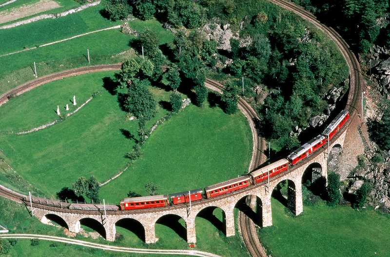
http://www.trainpics.de/gallery/switzerland/ch-bernina/rb17134.html
The south side of the Bernina Pass has one of the longest uninterrupted descents in the Alps. As I swooped around the nearly circular curve at the turn-off to Livigno, I got some rain from clouds approaching from the east. Fortunately the road heads west as it cuts through a ridge into the Val Poschiavo, where the narrow bumpy road makes a long almost straight descent. Even without pedaling, descending fast on such a bumpy road takes effort. This helped keep me warm as did the thought of hotel Bottoni in Brusio where Mr. and Mrs. Beti preside and serve great dinners.I leveled off at San Carlo and continued through towns where the RhB runs on tracks in the narrow one-lane highway, taking the right-of-way from cars in San Antonio and La Prese. With a tailwind, I rode easily in top gear around Lago Poschiavo to Miralago and descended the fast section to Brusio (781m), where I stopped at Hotel Bottoni, one of my favorite spots for lunch and overnight. After a hot shower and change of clothes, I savored a delicious meal and got lots of rest.
http://www.rail-info.ch/RhB-BB/pics/rhb5374.jpg
At Temú (1144m), just below Ponte di Legno, I stopped at the Locanda Veduta dell'Adamello just in time for lunch. Silvano Macculotti, the proprietor, was preparing to serve lunch for his family and I tailgated their feast with gusto. Well fed, I rode through Temú along the Frigidolfo, a torrent that rages through the middle of Ponte di Legno (1258m) as though intent on jumping its banks. Staying on the north side of the river, I reached the nearly flat, lush green valley below Pezzo where the road makes one large S-bend to start its climb.
Pezzo is a typically picturesque hill town, glued to the side of the mountain in what appears to be high-risk avalanche territory, where the shape of the slopes above town apparently protects it from the white death. I climbed through the larch forest to break out into the Val delle Massi at Appolonia (1585m). Here the Frigidolfo meanders across the flat valley with no hint of its cascades below or the waterfalls above.
I stopped at the gazebo which currently offers only one flavor of rusty bubbly mineral water instead of the former two. This water is thought to give strength to bicyclists who dare climb the Gavia or at least to those who dare to drink. After getting past the warning signs of landslides, rockfall, dangerous narrow road, and a requirement to have tire chains on board from September to July, I was on my way. Past the first hairpin, reality strikes as the road goes from highway to driveway width, and the 16% sign of poster fame sets the tone. The road is only that steep in places, but the signs are a warning for vehicles that cannot restart on such a grade after meeting a descending vehicle. The bicyclist can always walk past such obstacles.
Fortunately plans of the highway department to widen and pave the entire route have been laid to rest for now. The march of man against nature has stopped right there where the road meets the mountain. The road has lost nothing in character through paving and remains the same narrow one-lane Gavia that it always was. There is not much more traffic now, because the road is often closed by slides and rockfall.
I paused at the cliff where I had been photographed years ago for the poster picture that hangs on the wall in the Rifugio Bonetta on the summit. At the Rifugio, I stopped in to say hello and met some German bicyclists who had stories about these mountains similar to mine. Just then Mr. Bonetta came out of the kitchen and said "Jobst, you have mail". There, taped to the glass over my poster were two notes, one from Sterling McBride and another from Jan Johnson, the wife of my frame builder and good riding companion, who had been there a few days earlier. Mr. Bonetta asked me to add the date (1978) to my autograph on the poster. I thanked him for his hospitality and rolled off across the broad summit.
/Bike/Countries/Europe/Tour_Reports/Tour_of_the_Alps/Gallery/gavia.jpg
http://www.waltellina.com/ortlescevedale/bonetta/
Or, The descent is much easier on pavement than it had been on gravel, giving more time to appreciate the view. The Ortler (3905m) and Gran Zebru (3851m) with their glacial caps and perpetual glistening snow rise to the east, while the Valfurva Valley stretches out to the north. The Val di Gavia, that gets steeper after Rifugio Breni (2543m), got me down to the main road in Santa Caterina (1734m) quickly. Bormio (1197m) at the foot of the Valfurva Valley is a steep dash from the town of Valfurva (1339m). I stopped at my favorite hotel, the Albergo St Ignazio in a courtyard just off the Via Roma, the main street of Bormio, which has been remade into a pedestrian mall. To my disappointment, Braulio liqueur HQ had lost its rustic facade and interior in a remodel and now looked like any other liquor store. After a great pizza at the large pizzeria across from Braulio, I got a good night's rest for a long day to the Dolomites.http://www.paloaltobicycles.com/alps_photos/i79.html
As usual, many motorcyclists and bicyclists were gathered at the summit as I made my way to the edge of the precipice to the east. Here I had a clear view of the road, glued to the wall, as it makes 48 hairpin turns down the Val di Trafoi. A local bicycle hill climb was being held on this side from Prato, a climb that used to take me two hours. In contrast today I took three hours for the lesser climb from Bormio but enjoyed it just as much.http://www.paloaltobicycles.com/alps_photos/i43.html
I descended the Val Trafoi along the Solda River, through Trafoi (1570m) and Gomagoi (1267m) before rolling out of the canyon at Prato (911m) and taking the short straight run to Spondigna (885m), where I ate lunch. From here it's 50km down the Val Venosta to Merano (302m) and another flat 30km run to Bolzano (262m), a charming south Tyrolean city on the edge of the Dolomites.I headed north past the Bolzano train station into the Isarco (Eisack) Valley to Cardano, where I turned east into the Eggental on the Costalunga Pass road (Rt N241). Behind Cardano, the Eggenbach flows out of a rock wall that seems to defy penetration. The road is cut into the vertical dark red rock above the river, diving through tunnels to straighten the crooked gorge that isn't much wider than the road.
http://www.paloaltobicycles.com/alps_photos/i92.html
The road climbs with a 16% grade through this narrow slot, receiving little sunshine even at noon. The gorge gradually widens to a grassy valley and forested uplands. Higher up, glimpses of the Dolomites came into view on the approach to Welschenofen (1182m). Just above Hotel Diana, that has a giant mural of Diana the huntress with bow and arrow, the road flattens as it reaches the summit meadows.The myriad spires of the Latemar (2842m) were reflected on the deep turquoise waters of the Lago di Carezza. Across the meadows, the Rosengarten (2981m) was nearly ready to reflect the setting sun as I passed the junction to the Nigerjoch Pass, whose lower end is the 24% grade road to Tiers. Then came a short climb with a few turns to the Costalunga summit (1745m) and a long gradual descent to Vigo di Fassa (1400m) in the Val di Fassa. At Pozza di Fassa (1380m), on the Torrente Avisio, I happened onto one of the few two-star hotels in this area. I got a discount coupon for one of the finer restaurants in town, and after the long run from Bormio, the dinner did the trick to revive my enthusiasm for the beautifully rich Dolomites and their striking formations the next day.
From the Pordoi, I descended east to Arabba (1605m), in the Val Livinallongo del Col di Lana, at the foot of the Passo Campolongo (1815m), and followed the steep contours along the north side of this deep ravine. To the south, I saw Mt Civetta (3220m) framed by the canyon above Caprile and Lago d'Alleghe. Pieve (1465m), half way along Livinallongo, hangs from the steep slope with picturesque fortress-like architecture and well-kept flower boxes against a backdrop of Dolomites, a typical scene of the region.
At Cernadoi (1495m) I turned south on Rt N203 toward Colle Santa Lucia (1475m), which gives a near vertical view into Caprile (1014m). At Codalonga (1314m), just before Selva di Cadore, I turned up the Passo Giau (Rt N638), which is now only a steep road, but was formerly a coarse-gravel road with poor traction. I stopped at the Rifugio Piezza (2175m), a half kilometer below the summit of the Giau (2233m), for a gourmet lunch for which the place is noted.
What started as a clear sky gradually changed to billowing thunderheads as I descended to Pocol on the Passo Falzarego and down Rt SS48 to Cortina d'Ampezzo (1210m). Cortina knows how to keep an inviting appearance and has a lovely pedestrian friendly center. I rode up to the former train station and followed the "tracks" to the "railway crossing" north of the station that now only serves buses. Here Rt N48 climbs to Passo Tre Croci (1814m), where I took a last look back at the beautiful green sunlit Valle d'Ampezzo, Le Tofane (3248m) to the west, Passo Giau and its mountains across the valley to the southwest, the Gruppo Cristallo (2918m) directly above, and the Sorapiss (3205m) to the south, with Monte Pelmo (3168m) and many other peaks vanishing in the distance.
A short descent took me to Pian Maccetto (1650m) from which it's a short climb to Lago di Misurina (1748m), a reflecting pool for the Tre Cime di Lavaredo (2999m), a famous formation typical of the region and sought out by rock climbers. Thunder rumbled ominously as I rode past the large hotels along the lake to the Col San Angelo (1756m), also known as the Passo Misurina, and climbed over a little bump to descend into the Val di Landro along the Rienz River.
I rode down the valley that descends gradually to Dobbiaco (Toblach; 1241m) on the broad east-west divide of the Pustertal between the Drau and Rienz rivers. I took Rt N49 east along the Drau toward Lienz (673m) in Austria as the clouds merged into a high overcast. I rolled down the slight grade to the border at Winnebach (1113m), a crossing that was all but dead, as are most in the EU. It was much like a sign for a state border in the USA. The railway, although now electrified, still doesn't seem to carry much freight or through traffic. I stopped in Tassenberg (1100m), at a small road junction for the day, shortly before it began to rain hard.
Although the Gail River flows down the valley to Mauthen (710m), the road has many ups and downs as it passes through picturesque villages with a backdrop of the Dolomites to the south. I headed north from Körtschach-Mauthen to Oberdrauburg and to Dölsach (799m) at the foot of the Iselsberg Pass (1204m). The Iselsberg lies between the Drau River in the Pustertal and the Möll River in the Mölltal.
Having worked up a thirst on this pleasantly warm day, I stopped at a roadside refreshment stand in Winklern (958m) in the Mölltal and gulped down a cold half-liter Coca Cola the way I usually do. The lady behind the counter admonished me, "How unhealthy! You should always warm such drinks first!" This reminded me of my early bicycle tours and how long it has taken to bring cold soft drinks to market here, let alone cold beer.
I rode up the Mölltal to Heiligenblut (1301m) at the foot of the Großglockner Pass, an easy cruise with a bit of climbing here and there. I found a comfortable Gasthaus just below town where I could see the Großglockner peak just behind the tall slender church steeple in town.
The Großglockner (3798m) peak was not visible this morning although the road to the summit was. The Dolomites to the south had vanished in the clouds as I approached the Hochtor summit (2505m), but at least it was dry. I rode through the 200m summit tunnel hoping for clearer skies to the north, but it was still cloudy.
After passing the lake before Mitteltörl (2328m, the middle summit), I rode through the curved tunnel and down a short 12% grade that took me to a 12% climb to Fuschertörl (2428m, the north summit). Clouds obscured most of the usual striking panorama. I descended the 12% run to Fusch in the Fuschertal and continued to the north toll gate and wildlife park at Ferleiten, where it got pleasantly warm with some sunshine.
With a nice tailwind, I rolled down to Bruck (757m) on the Salzach River, passing through villages with roadside displays of wood carvings and rustic furniture, Austrian art for the tourist. I crossed the Salzach and cut across on the Flugplatzstrasse to Zell am See, where Porsche Design is located. I dropped in for the usual short visit with my old working companion from the 1960's, Ferdinand A. Porsche, who hasn't changed much over time. We talked of old times, and then I headed up the Pinzgau Valley through Mittersill. The Pinzgau has its own narrow gauge (760mm, 30inch) railway that serves the valley with freight and passenger trains. The quaint pennywhistle of a train heading toward Zell greeted me from tracks that parallel the road much of the way.
In Mittersill most traffic heads north or south, but I continued west toward Wald (867m) at the foot of the old Gerlos Pass. The farther up the valley I got, the darker the clouds over the pass got. In Wald, near the end of the valley, I took the steep narrow old Gerlos road, cutting above the church from the grocery store to head up to Gasthaus Grubl, a great place to stay, and say hello to Mrs. Kaiser who runs the place. The hotel lies in a crook in the road, where a small creek runs over a decorative water wheel that once drove a generator. I got a mid-afternoon apfelstrudel for strength for the climb up the 500m of 17% just above. Of course the rest of the hill was a piece of cake... or strudel.
I ran into rain squalls and clouds near the top of the old Gerlos Pass (1486m), though the road was mostly dry over the summit where it joins the new road. But that was the end of the reprieve. Horrendous downpours followed as I descended past the huge earthen dam to Gerlos (1245m). The road stays high after Gerlos while the Gerlos River rushes down the Gerlostal, a narrow defile. From Hainzenberg (1000m), the road finally takes a series of hairpin turns to descend to Zell am Ziller (575m) in the Zillertal.
Just before town, the road was dry again, but the thunderstorm was close behind. People in swim suits frolicked about in the warm summer weather, and bicyclists in summer clothing rode by as huge drops began to splash onto the pavement. The street quickly turned into a steaming river on the warm pavement as people scurried for cover.
I headed north down the Zillertal where the Ziller, that was still clear blue in Zell, was racing along, dark as chocolate milk near the top of the levee. I had no idea that this was the beginning of the central European floods that inundated large areas along the Inn, Danube, Elbe and other major rivers. I reached Strass (523m) on the Inn River, about 20km down the Zillertal, and found lodging at Gasthof Pfandler.
The road remains fairly flat until Haiming, the mouth of the Ötztal, at the upper end of which the Timmelsjoch (Passo Rombo; 2474m) crosses to St Leonhard and Merano in South Tyrol. With mini-markets at most of the gas stations on this road, I stopped for a snack at the junction and tanked up on liquids before crossing the high bridge that spans the Ache River from the Ötztal and then another bridge over the Inn, where the water had also become a muddy torrent. After the high bridge I climbed two kilometers over the narrows of the Inn.
After a two kilometer descent, I turned off to Bahnhof Imst and the river rafting set-in to take the bicycle path to Landeck. The path lies between the motorway and the river and avoids the climb to Imst and Imsterberg that I formerly had to do before the motorway was built. There were no rafters today, probably because the high-water was dirty and full of floating debris. I stopped at Zams for lunch, then rode through Landeck (816m) to the Arlberg highway (Rt N1), turning off at Pians into the Paznauntal and the Silvretta Hochalpenstrasse toll road (Rt A188), which heads over the Bielerhöhe Pass to Bludenz in the Montafontal.
Although the sky had changed to solid overcast, I still had my light tailwind up this gradual climb along the Trisanna River to Galtür. Here the wind made an abrupt reversal and became a stiff headwind that I didn't need because the road gets steep for the last 500 meters to the Bielerhöhe Pass (2021m). The Silvretta lake straddles the summit and is contained by an earthen dam on the east and a concrete dam on the west. I saw only fog over the lake, where on previous trips I saw the glacier-covered Eckhorn (3117m), Wiesbadenerhöhe (2490m), Piz Silvretta (3248m), and Piz Buin (3312m), set off against deep blue water.
Just beyond the dam, dense clouds and rain made the descent of 32 hairpin turns slow and tedious. I finally came out of the clouds and rain at the bottom of the steep part, in Partenen (1027m) on the Ill River in the Montafontal. From here I rolled against a dwindling headwind to Bludenz (585m), where I found an interesting hotel by following little obscure signs to Hotel Daneu in Neuziders, a residential suburb above Bludenz. I was favorably impressed by the whole show -- dining, lodging and cost.
At Mülehorn I took the road over the corner of the Kerenzerberg into canton Glarus. This is only a shortcut on the map, but I find the climb worth the effort for its scenic beauty of the Walensee below the Kurfirsten range that rises 2000m directly from water on the opposite shore. After reaching the summit in Filzbach (800m), the road levels off for a while before gradually descending to Mollis (450m) and Netstal on the main road to Glarus (472m).
Typical of the side valleys is the narrow Klöntal, that rises to the west of Glarus and has a lake whose water is light green with glacier milk. Steep mountains rise above the lake and vanish in the mist, while a small road climbs past the lake to the Pragel Pass (1550m), which crosses to Bisistal and Muotathal in canton Schwyz. This road, with a long 18% grade down to Bisistal, is closed to motor traffic on weekends.
From Glarus, traffic was light on Rt N17 to the end of the Linth Valley that ends in Linthal (648m), a town that is still served by regular SBB trains even though there is little traffic. To me, the Glarner Alps are especially striking because the highest peak, the Tödi (3614m), is framed by the valley in this canton with almost no flatland. The glaciers of the Tödi, nearly always frosted with fresh snow, glisten especially brightly after cloudy weather.
From Linthal the road climbs into the almost vertical west wall of the valley to Urnerboden (1300m), a valley that is about 500m long and has nearly vertical walls on three sides. The final climb to the Klausen summit starts at the upper end of the Urnerboden into the headwall at Spitelrüti (1400m).
Riding was comfortable in the cool afternoon air as I climbed above the valley on long traverses that made a hairpin turn when they reached the wall on one end or the waterfall of the Fätschbach on the other. Farther up, several short S-turns rise to the gap of the Klausen Pass (1948m). I rolled over the summit of dark red rock earlier than in other years and descended through still air past the summit hotel and to the cliff above the Schächental. From the cliff I got a spectacular view of the Tödi 1700m above and the roofs of Aesch (1234m), lying 700m vertically below. Here a hiking trail wends its way up the headwall to the Klausen summit. From the Hüfifirn Glacier of the Tödi, the Aesch cascades to the lip of the gorge to drop the last 600m in the freefall Steubifall, drifting to the valley floor in a cloud of mist.
The road along the cliff is cut into the rock with only a 50mm diameter steel pipe as a guard rail a meter above the road to protect against a huge free-fall. This demands caution as the enticing panorama unfolds. After the wall it's a few tunnels and sharp curves before a straight shot to Hotel Posthaus Urigen (1300m). It was neither dark nor raining as it had been on several recent tours, so Stefan and Karin Truschner, the proprietors, were surprised at my "early" arrival. I took the usual room, with bath down the hall, in the beautiful annex with carved wooden beams, colorfully decorated with painted verses and sayings. After a shower and change into "formal" wear I had a good dinner.
In Altdorf (458m) I headed up the Reuss Valley toward Erstfeld (472m), where the SBB begins its climb at 2.7% grade toward the 16km Gotthard Tunnel. Erstfeld is also the north portal of the 52km base tunnel that is being bored through the Gotthard to Bódio. One of the famous old "crocodile" Gotthard freight engines is on display near the train station. A short way up the valley, at the SBB hydropower plant in Amsteg, the road abruptly begins climbing on a steep stone bridge over the Reuss and then cuts into a bench on the opposite wall.
From Amsteg, many tunnels and bridges for railway, motorway, and highway are needed to climb the narrow canyon over the cascading Reuss. Because most traffic uses the motorway, the old highway is nearly empty. In Wassen (916m), I took the Susten Pass road (Rt N20), which starts climbing into a bare rock tunnel across from the granite block city hall and plaza paved with large granite slabs surrounded by a low granite colonnade.
Wassen is noted for lying between three loops of the Gotthard railway, so that its church can be seen on opposite sides of trains as they make the three passes. The station platforms are marked with exaggerated signs indicating that the northbound track heads south and visa versa. Besides, Swiss railways run left-hand traffic, making it even more confusing to foreigners.
A brilliant blue sky with white puffy clouds made a fitting final run as I headed up the glacier highway of Switzerland, much of the climb being one long gradual curve along the wall of the Meiental. I stopped for a drink at an ice cold stream above Fernigen (1455m) and again at the kiosk at a large waterfall, where I put away a couple of Coca Colas for the climb to the top.
Emerging from the 200m Susten summit tunnel (2224m) exposes a stunning panorama of glaciers and peaks, foremost amongst them the Sustenhorn (3503m) and its huge Steingletscher, whose ice reaches to the valley far below. The ride down the Gadmental is exciting, with rough hewn curved tunnels opening vistas to ice fields. One short tunnel carries a waterfall that would otherwise fall on the road if it hadn't been artificially channeled over the tunnel.
The last piece down to the Haslital is fairly steep and starts with curved tunnels before Wyler, just above Inertkirchen (625m). After Inertkirchen I sprinted up the four legs of the Kirchet (709m) to stop again at Gasthaus Lammi, this time in sunshine, where I savored a hearty meal that I had visualized on the way up the Susten. From here it's an easy roll down to Meiringen (595m) and to the base of the Brunig Pass (1008m), which starts with a 13% grade in the shade of trees. At the summit, I took a last look back at the glacier-covered peaks before descending to Kaiserstuhl on the Lungernsee (752m) and down to Giswil (485m) at the base of the hill. I continued through Lucerne and back to Affoltern the way I had come.
Many of the places mentioned in this report can be seen on:
http://www.paloaltobicycles.com/alps_photos.html