See the Jobst Brandt's Tour of the Alps Collection under the section for Europe of the Trento Bike Pages.
By
On Thursday, 26 June,
As we got ready to leave, I realized that the shopping bag
with my bicycling clothes was still standing in my kitchen at home, so we
visited two bike shops to get refitted, size 48 SPD shoes being the main
problem. Back in Ibach, properly equipped, we finally got on the road at about
http://www.schweizerseiten.ch/info/info_axenstrasse.htm
The Axenstrasse is noted for its rocky cliffs dropping steeply to the water. The railway stays mostly in tunnels, and we ducked in and out of short tunnels as we made our way to Flüelen at the end of the lake. It was along these cliffs that William Tell is said to have duped the Austrians who had taken him captive. They were returning by boat to their headquarters when a fierce storm arose. Tell convinced them to take off his shackles so he could guide them to a safe landing along these cliffs. Instead he jumped ship when they got close to the wall and vanished up trails that only the locals knew. The Austrians went under, according to the chronicles of Friedrich von Schiller, who created William Tell as a composite figure of the Swiss nationalists.
http://www.picswiss.ch/Historie/g-hip3-7.html
http://www.bartleby.com/26/6/
http://agora.unige.ch/ctie/ur/bsu/tell/deut/tellsprung.htm
In Altdorf, with a mural of the Alps of canton Uri as backdrop, Tell stands proudly, bigger than life, in bronze, son at his side, with crossbow (Swiss trade mark) over his shoulder.
http://www.tell.ch/schweiz/telldenkmal.htm
http://www.ur.ch/
There isn't much flatland in Uri and most of that is taken
by the Reuss, the Swiss federal railway (SBB), the
We started climbing above Erstfeld at the SBB hydropower plant in Amsteg, where the grade gets steeper abruptly across a stone-arch bridge over the Reuss. The highway wends its way along the granite walls while the double track SBB, in order to not exceed a 2.7% grade, uses helical tunnels to gain altitude on its way to the 16 km Gotthard Tunnel. Meanwhile the four-lane autobahn remained mostly out of sight in tunnels and avalanche sheds.
The SBB makes three passes using looping tunnels to gain elevation at Wassen (916m). The Wassen train station lies between two of these loops so that trains pass opposite from their logical direction, northbound trains traveling south and southbound trains, north. Although the SBB runs left hand traffic, these tracks are signaled in both directions so that trains can run in either direction during maintenance, making train boarding even more confusing at times. The Wassen church is famous for being seen three times from the train, from below, at grade and from above.
We stopped for some food before heading into the Meiental
that lies hidden behind a granite wall through which the
http://www.paloaltobicycles.com/alps_photos/s42.html
A thin high overcast was augmented by thin stratified fog as
we reached the summit tunnel of the
http://www.aareschlucht.ch/englisch.htm
Just beyond the pass, across from the Lammi restaurant, we turned off to Rosenlaui. This road is steep and little more than one-lane wide as it climbs through a forest to the canyon of the roaring Reichenbach where Sherlock Holmes and Dr. Moriarty met their deaths over the falls in 1891.
http://www.evo.org/sherlock/europe/reichenbach_falls.html
Hotel Zwirgi in Schattenhalb, the junction of the road from
Meiringen, was elegantly rebuilt, looking much like the old one that burned to
the ground two years ago. I stopped at the water works for a big drink of ice
cold water where the phrase "Das Wasser ist das Beste" graces the
wall above the fountain. The climb to Rosenlaui is still no trifle as it
rapidly gains altitude past hotel Kaltenbach, finally leveling off in the
http://www.paloaltobicycles.com/alps_photos/s38.html
Although it had rained a bit before we got there, we got a splendid view of the Rosenlaui Glacier as we rode along the now placid Reichenbach. At Hotel Rosenlaui we were met by Andreas Kehrli, the proprietor, who was caring for a large tour group. As has happened before, the hotel was full but there was still room in the dormitory annex where we could stay, thanks to the boss. As always, we had a hearty dinner and a great stay.
http://www.alles-fahrbar.de/alte_homepage/Mountain2002/17bild.htm
We got underway early after a rich buffet breakfast and started
up the easy part of the
This beautiful route climbs through meadows with grazing cows amidst wildflowers, all in the shadow of the massive Wetterhorn. We passed a new wooden farmhouse with beautifully hand-carved beams, windowsills, and flower boxes. An inscription with the year 2002 carved into its main transom will remind people after it has become nearly black with time, like its century old neighbors, when it was that the wood was fresh and yellow.
http://www.paloaltobicycles.com/alps_photos/s37.html
http://www.paloaltobicycles.com/alps_photos/s84.html
Even with fair weather, or maybe because of it, we could hear icefalls crashing down the Wetterhorn (3701m) that was still casting a long shadow our way. From Große Scheidegg (1961m), under beautifully clear skies, we saw the dark north face of the Eiger in front of the pure white Jungfrau with Grindelwald (1034m) lying below like a miniature village amidst steep green meadows.
We were back on public roads as we passed the Grindelwald train station, where the Berneroberlandbahn (BOB) meter gauge (adhesion and Riggenbach cogwheel) railway makes connections with the Wengeralpbahn (WAB) 800mm gauge (Riggenbach cogwheel) train that crosses the valley to the Kleine Scheidegg (2016m). Here the famed Jungfraubahn meter gauge (Strub cogwheel) tunnels inside the Eiger (3970m) to the station in an ice cave on the Jungfraujoch saddle (3454m) between Mönch (4099m) and Jungfrau (4158m).
Following the cascading Schwarze Luetschine that joins the Weisse Luetschine
from Lauterbrunnen at Zweiluetschinen, we crossed the river on bridges engulfed
in chilled air from the icy river. The road levels off at Wilderswil (584m),
where the Schynige
We passed the large meadow in the middle of
http://digilander.iol.it/zh/cograilways/brienzer.html
We photographed Sherlock Holmes, in life-sized bronze, with pipe, cape, and deerstalker cap sitting in the middle of Meiringen, the home of meringue. After Willigen, a short climb up the Kirchet (709m) got us to the Lammi that we had passed the day before, for lunch. Under Eichhof and Rivella umbrellas, we and many motorcyclists enjoyed a good outdoor lunch.
On the way to the
http://www.paloaltobicycles.com/alps_photos/s90.html
Above Handegg the road enters a one-kilometer tunnel where
bicyclists must (and prefer to) take the old cobblestone road, notched into the
granite wall high above the
From the Grimsel, the
http://www.paloaltobicycles.com/alps_photos/s67.html
The climb is easy with only one steep section before the photogenic hairpin turn below the Belvedere (2272m). This place offers a great opportunity to pose with the bicycle in a hairpin turn with a glacier backdrop.
http://www.paloaltobicycles.com/alps_photos/s10.html
The
http://www.furka-bergstrecke.ch/
We crossed the Furka summit and coasted swiftly through
Tiefenbach and Galenstock on the long 8% descent to Realp (1538m) at the base
of the grade. We cruised on the long straight road down the valley, next to the
Furka Oberalp RR to Hospental (1452m), the junction of the Gotthard and
http://www.zumdoerfli.ch/roessli/hotel.htm
We rode up the old cobblestone street of Hospental, formerly
the main road in the days when highways connected towns and had no reason to
bypass them. We joined the wide concrete
offset against dark green leaves, often surrounded by bouquets of deep blue gentians, pale blue forget-me-nots, and many varieties of daisies and dandelions.
As often, various motor rallies take place on summer weekends and today it
was Lanz Bulldog day, for the one-cylinder farm tractor that plowed the big
fields of
http://home.germany.net/101-27793/bulldog.htm
I posed for a photo at the Gotthard (2108m) summit sign at the lake as I had
on my first tour in 1959. We photographed the serpentine curves of the old Val
Tremola road from the new road before entering the long tunnel that emerges
high above the Val Bedretto on a flying hairpin turn, 520m above
http://www.paloaltobicycles.com/alps_photos/s04a.html
http://www.paloaltobicycles.com/alps_photos/s01A.html
From Airolo the road, autostrada, railway and
http://mikeaz.free.fr/suisse/piotta01.htm
At the end of the
We passed two more circular tunnels at Anzonico before rolling into the wide
and flat valley just above Bodio (322m), the south portal of a new 58km
Gotthard Railway Tunnel. We rode through Biasca where, due to the heat and
drought, the crossing waterfalls were not crossing and had only a trickle. From
Bellinzona (239m) we took a road construction detour around Giubiasco that got
us away from the Lugano and
http://www.alptransit.ch/pages/e/galerie/index.php#
Most traffic went south over the Monte Ceneri Pass (559m) to Lugano and Milano while just beyond, at Quartino, most remaining traffic went toward Locarno on the west shore of Lago Maggiore (193m). We stayed on the east shore, stopping in San Nazzaro for lunch. We crossed the Italian border at Zenna where we were waved on as usual... but not always.
In Luino my favorite bancomat wasn't working so we had to find another to
stock up on Euros. From Luino we rode along the lake in a series of tunnels and
slide protection galleries and then climbed over a hill to Laveno. We took the
ferry across the lake and landed in Intra, on the fancier western shore with
its famous resorts. We rode up the Valle d'Ossola along the
At Gozzano (367m), on the south end of the lake, our road headed west along the hills climbing a short steep hill to Pogno (461m), where the four-spigot fountain on the piazza would have come in handy but it was out of order. We climbed west up a canyon in a blooming chestnut forest, typical of the southern slope of the Alps, and broke through the ridge at an unexpected tunnel (598m), from where it was all downhill to Borgosesia (359m). The Sesia was still not entirely recovered from the summer floods of 2002 but there were swans and ducks in the less-than-crystal-clear waters. We found a reasonable hotel and had a cool night’s rest here in the Piemonte.
We climbed to Valle Mosso and rolled down the long descent
to Pettinengo in the valley and crossed a few low ridges on the way to
After lunch, Brian suited up and paced us on a fast ride through the hills
on back roads to
When we reached Carignano, we stopped and an owner of an electrical
appliance shop became concerned about Jeanie's distress. He stored our bicycles
in his store and took us to the local first aid crew who seemed unduly
enthusiastic to have a patient. We were glad for the ice-pack but the ride in
their ambulance to
Rt SS20, the Tenda highway, took us south to Carmagnola, and
Raconigi, the former residence of the
http://www.leksykony.pl/zamki/wlochy/racconigi.html
As we approached
We took a right just after the bridge and stopped for a good drink from the
huge fountain in front of the
Most of the storm damage from last year, along the
http://www.paloaltobicycles.com/alps_photos/f64.html
http://www.paloaltobicycles.com/alps_photos/f89.html
Sixty or so hairpin turns descend steeply into the ravine of
the
http://www.paloaltobicycles.com/alps_photos/f89.html
Below, in the rocky gorge of the
http://tinyurl.com/k8b7
http://www.provencebeyond.com/villphotos/breilP01.html
After the brisk ride down the Roya, past Tende and the Gorge
du Soarge, we stopped in St. Dalmas for a grocery store snack before turning
west up Rt D2204, just above Breil (286m), to the Col de Brauis (879m). The
landscape is
The descent to Sospel (349m), the junction of the Brauis,
Braus, and Turini passes is pleasantly gradual. We took a picture of the old
stone arch bridge and its collage of buildings over the
We headed up the valley on Rt D70 to the
On the road up the gradual grade to St. Martin Vesubie
(930m), fever caught up with me and I had a hard time reaching town, resting a
couple of times even though it wasn't hot and the grade was light. The usual
Hotel Le Gelas was full so we found a hotel on the main square where we ate
dinner and I took a big rest. St. Martin Vesubie is a pleasant town lying at
the foot of the narrows leading to
http://www.provencebeyond.com/villphotos2/stmartinP1.html
No fireworks, just rest.
After a day’s rest I felt better but unsure of how my
wheezing body would work. To my surprise I got better as I rode up the Colmain.
The climb exposes a beautiful panorama of
http://www.fortunecity.com/greenfield/macdonalds/296/a/a1/avionroquero.htm
Across the Tinée, in the Gorges de Valabre, roads that are
tiring just to look at follow tortuous paths up through cliffs to mountain
villages like Ilonse (1200m). We crossed the Tinée at St. Sauveur (510m) on Rt
D30 and headed up the Col de la Couillole (1678m). Near the top, we passed the
ancient
http://www.provencebeyond.com/villages/roubion.html
We took the "back" road, Rt D29, down to
Guillaumes (1200m) and rode up Rt N2202 in the Gorges de Daluis along the
http://www.paloaltobicycles.com/alps_photos/f88.html
As most days, we started off with a tailwind, even if it was
only a light breeze, as we rode up the
We started up the Route des Grand Alpes (D902), climbing the Col de Vars (2111m) just beyond the junction with the Col de Larche (1991m), aka Colle della Maddalena from the Italian side. Interestingly, Col de Vars has kilometer posts with distance to the summit and average gradient, and has a randonneur sign-in stamp at the summit, something we didn't notice elsewhere. At the summit I was surprised to see that the ramshackle corrugated steel shed, that I first saw in 1960 and had collapsed during the winter of 2001, was again repaired after being a mere pile of corrugated sheet metal last year. Of course I bought some post cards and a soda.
On the descent to Guillestre (1000m), I could make out the gap of the
Our tailwind turned into a headwind as we started up the straight steep
section from Arvieux past Brunnisard to the
http://www.paloaltobicycles.com/alps_photos/f72.html
From the Izoard (2361m), the gap of the
The
The new Hotel des Glaciers on the Lautaret summit was splendidly built after the old hotel burned three years ago. Last year I found that the new hotel was designed around the grand dining room and centerpiece of grandfather Bonnabel's unfinished project and that it exceeded the expense and class of hotels that I chose to stay in. I tried it once and that was enough. Neither of the Bonnabels were there when we dropped in to say hello, so we rode on up the Galibier in the cool morning air.
The Galibier road is a bit steeper but still mild up to the summit tunnel that has been reopened after 40 years or so, enabling tour buses to once again carry their guests over this pass. In contrast to last year, cars were waiting at the traffic light at the one way tunnel (2555m) so I didn't try to ride through it this time.
We road over the top (2645m), where we had a panorama of the glaciers of the Massif de la Vanoise (3600m) and the Massif du Sorieller (4000m). The descent from the tunnel portal is about 6-8% to Plan Lachat, where it requires pedaling over a long flat section.
http://www.memoire-du-cyclisme.net/eta_tdf/presentation_tdf.php
http://www.paloaltobicycles.com/alps_photos/f30.html
At Valloire (1430m) streets were jammed with an ATV show that took over the whole town, and we lost a bit of time by not taking the detour around town and weaving through all the stands and parked vehicles. I didn't believe a trade show could so solidly block all the streets that a bicycle couldn't get through. It was cloudy with high overcast as we climbed from Valloire (1430m), to the Telegraph (1570m) before descending to St Michel du Maurienne (712m).
As we descended the Telegraph we could see that highway construction had
progressed enough that we would have it fairly easy in contrast to the detours
and heavy construction traffic of last year. It was fairly calm as we rode up
the old highway with most traffic on the completed motorway to Mo
Just above Mo
The road levels off next to the Barriere de l'Esseillon, a
deep defile of the
http://www.onera.fr/geographie/modane-avrieux.html
http://www.onera.fr/geographie-en/modane-avrieux.html
Beyond the gorge, we descended to the valley floor and rolled
gradually up to Termignon (1300m). From here, it's a short climb to Lanslebourg
(1399m), from where the Col du Mont Cenis (2083m) connects to
We stopped for a snack in Lanslevillard, the upper end of Lanslebourg, below
the Col du Madeleine (1746m), a short but steep climb into the high valley of
the Arc. On the way to Bonneval-sur-Arc, at the end of the valley, great
panoramas of the Glacier des Evettes on the slopes of the Croce Rossa (3546m),
Uia di Ciamarella (3676m), and l'Albaron (3638m) open to the east. We stopped
in Bonneval-sur-Arc (1835m) at the big sweeping turn where the main climb to
the
We made the two long traverses from Bonneval up to the Gorge
de la Lenta, a box canyon that lies south of the pass. The road climbs up the east
wall and over waterfalls and through bare rock tunnels. At the top of the
headwall, where the Lenta cascades into the gorge through a slot, the road
crosses the river on a stone bridge to enter a narrow high valley. From here,
two long traverses to the summit of the
http://www.paloaltobicycles.com/alps_photos/f20.html
http://www.paloaltobicycles.com/alps_photos/f83.html
After a photo stop at the large concrete sign on the summit,
we put on jackets and descended to Val d'Isere. Under the beautifully clear
skies, many vistas that I hadn't seen in recent years were visible, reminding
me of past tours. At Ste. Foy-Tarentaise (1051m) we took Rt N90, a 'shortcut'
to
We joined Rt. N90 below Rosiere (1850m) and rode on to the
After breakfast we pushed off into beautiful sunny weather
and rolled up the gradual climb of the Valle del Gran
Val d'Aosta, originally being a French-speaking region, is a mixture of
French and Italian place names. Courmayeur at the entrance to the Monte Bianco
Tunnel to
As we reached the summit of the Gran San Bernardo (2469m) we rode around the summit lake to take a picture at one of the last Swiss concrete road signs of the 1950's, where I posed just as I had back then. The sign is still there because the snow plow driver cannot knock it down, it being up against the monastery building... but he tried. The base of the post is cracked to expose its reinforcing bar.
I found the kiosks had horribly bad taste but they sell what the tourists buy and that is fuzzy, toy St. Bernard dogs in all sizes from pocket to life sized. The descent seems short before joining the tunnel road, although it is the same elevation change as the south approach. The road has long avalanche sheds and fast alignment so coasting at a brisk speed is a breeze.
We reached the valley at Orsiérs (901m) and rode the slight grade to
Martigny (471m), pedaling lightly. As expected, we had a tailwind up the
Traffic was light, because most of it was on the parallel A9 motorway. This
broad valley is the great fruit basket of
After Sion with its twin knobs with castles we passed Raron,
the south portal of the new 42 km long Lötschberg base tunnel. Tunneling
machinery, like that at the Gotthard, was hard at work bringing out huge tailings
from under the mountain. Visp, the gateway to
After a brief visit in Brig (681m) we started up the
I rode up the new Simplon road while Jeanie took the old road that is both shorter and steeper. The roads join just above the curved Schallberg tunnel into the Gantertal, high above the Saltina, the river through Brig. About a kilometer farther, on this nearly flat section of the road, a high concrete suspension bridge crosses the Gantertal to Berisal (1520m). The old road went around the end of valley that is an avalanche chute and was impassable in winter.
From Berisal we continued in the shade of a larch forest up
to tree line where long avalanche shelters cover the road most of the distance
to the Simplon summit (2005m). The air on the climb was pleasantly cool and
under the clear sky the Eiger and the Aletsch Glacier were visible in the haze
to the north. The
http://www.picswiss.ch/Land10/VS-10-05.html
Today was a low-traffic day as we swept down into the galleries
along the granite walls of the Gondo gorge, high above the
http://www.paloaltobicycles.com/alps_photos/s25.html
About a kilometer above Crevola d'Ossola (337m), that lies at the end of the narrow part of the canyon above the Valle d'Ossola, the highway enters an autos-only tunnel where bicycles must (and prefer to) take the old road into town. Shortly beyond the tunnel entrance we stopped at the graceful and ancient stone arch bridge to take a picture with Jeanie sitting on the top of the arch. We turned east at Crevola d'Ossola to the Val Antigorio passing Crodo (the home of Crodo Acqua Minerale) and on to Baceno (655m) for lunch at the confluence of the Toce and Devero rivers.
It being Thursday, the great waterfall, the Cascata del Toce, would be flowing, but from what was coming downstream, it looked as though the heat wave and drought reduced the falls to a minimum. Ente Nazionale Energia Elettrica (ENEL) the electric power authority takes all the water except Sundays and Thursday afternoons. From Baceno we followed the Toce up the Val Formazza where big trucks carried huge blocks of granite down to the stone works in Domodossola. This region has many granite quarries that supply these huge blocks to be made into beams, posts, slabs, curbs, table tops, roofing stone and decorative sculptures.
As we approached the top of the valley we could see the falls visible
through the trees as the road began its climb in the granite wall of the gorge.
Much of the road beneath the falls is in tunnels and avalanche sheds that end
just before the Albergo Cascata
http://www.itinera2000.org/tedesco/walserted/doc/walserted-117.htm
This year the Giro d'Italia on Friday, 30 May, had a stage
finish here, with Gilberto Simoni winning the stage in his 39t-21t gear, as he
says. However, for touring, this is a beautiful route that above the falls
enters a high Valle di Morasco with the
http://www.paloaltobicycles.com/alps_photos/i54.html
http://www.paloaltobicycles.com/alps_photos/i35.html
The road levels off in the Val Toggia (2000m) and then
climbs above the dam of Lago Toggia (2191m). With the heat wave that preceded
our tour, there was no snow or ice on the lake as there was in other years.
Today the lake was emerald blue and surrounded by green meadows and
wildflowers. The road rises gradually past the lake to the San Giacomo Pass
(2313m), where a small stone house at the end of the road marks the Swiss
border. From here, only hiking trails continue. Over the years I have found one
route that works best, the one marked for the
The technique I use for descending steep hiking trails is to walk next to the bicycle applying the front brake while not restraining the bicycle by pulling back (up) on the bars. Pulling on the bars lifts the front wheel and puts the entire braking burden on the legs of the hiker. When I saw that Jeanie was having difficulty descending the trail, we traded bicycles and I discovered that what was easy with my bicycle, even with one hand on the bars, was difficult with Jeanie's dual pivot brakes, with their higher mechanical advantage. Although we weren't fast, the descent was, because it was so steep.
Near the bottom of the trail a mine seeking mountain crystals cut across the
path so that we had to take a steep cutoff. However, the miners had installed a
good temporary bridge across the
The morning was a breeze as we coasted down the Bedretto
valley to Airolo and took a picture of the flying hairpin turn on the Gotthard
from
As we passed Ristorante Beer in Mesocco, where the same host presided for as many years as I can remember, there was a faded "Chiuso" sign in the door. This was sad because I so much wanted to once more experience the owner's ability to recite complex menus from memory and to keep in his head what every guest ordered without notes. The last two years, when he was still in business, I arrived on Wednesday, his "rest day".
We stopped at the grocery store just up the road and confirmed the suspicion
that Hotel Restaurant Beer was closed for good. After a snack we started up the
granite paving stones of Mesocco's 13% main street into a light breeze. The
grade eased a bit at the end of the cobbles as the road climbed hairpin turns
to Pian San Giacomo (1170m). From here the road meanders across a small valley
before climbing over a ridge to
After lunch, we rode up the most scenic part of this climb through glacial formations, amidst running water and green meadows of wildflowers, bog cotton, and alpenrosen. Remnants of the ancient Roman road, with large edge stones, still remained in a few places where it had not been obliterated by the new road.
We rode around the summit lake and past the
We descended into the
We climbed along the stream through lush green meadows of the upper valley that were rich with the usual wildflowers and orange dandelions that seem to thrive at higher elevations. We saw only Wagtails along the creek where in past years I had seen Dippers, odd birds that walk under water. A Swiss Customs house lies above a stack of hairpin turns, a couple of kilometers below the summit, standing forlornly on an outcropping in the eye of a hairpin turn. Border guards have a sweeping view of the road from the valley up to the Splugen summit (2117m). Farther down at the Italian station, they gave our 'documenti' a thorough investigation, asked no questions and then let us continue.
Monte Spluga (1908m), a small village with granite houses with granite roofs at the upper end of a large ENEL lake, looked a little less depressing in sunshine than usual. The granite face of the dam carries a giant relief of "MDIVXXXV", its construction date. From here the road is unusual in that much of it is covered in avalanche protection tunnels. In some places hairpin turns are stacked one above the other in cliffs. Although most of its one-lane sections have been widened, tour busses still avoid it for its tight curves. An alternate, but longer route with more generous curves, branches off in Isolato.
We descended the Val San Giacomo along the Liro river as the valley widened
and became less steep on the way to Chiavenna (333m) in the Val Bregaglia. We
turned up the valley toward the
I was glad to see that although the road was widened, the leaning rock above Sottoponte was not destroyed and is now a narrows, probably because the new bypass tunnel was completed before getting a chance to blast this beautiful artifact.
http://www.paloaltobicycles.com/alps_photos/s15.html
We rode up the Val Bregaglia along the Mera to Casaccia
(1458m), where the Septimer Pass (2310m), a Roman road, heads north, an
interesting climbing adventure that I once took over to Bivio (1769m) on the Julier
Pass (2284m). From Casaccia the road climbs steeply into a bowl and ascends the
south wall to the
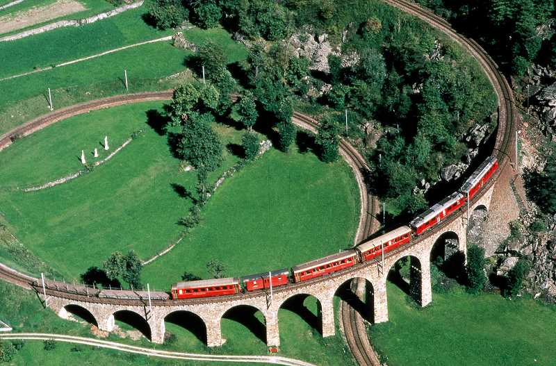
The
Up the Val Bernina, at the Bellavista curve railway crossing (1950m) of the RhB Railway, we stopped for a picture, but as last year, no train came by to be photographed in front of the glacier. Instead we took pictures of bicycle racers rounding the curve. The upper Val Bernina is fairly flat but after the Diavolezza and Lagalp funiculars, the road climbs the last bump to the Bernina summit (2323m). Two lakes lie on opposite sides of the divide, where the waters of deep blue Lago Negro flow via the Inn and Danube rivers to the Black Sea, while those of milky white Lago Bianco flow via the Cavaliasco and Adda rivers to the Po and the Adriatic Sea.
http://www.trainpics.de/gallery/switzerland/ch-bernina/rb17134.html
The south side of the
http://www.rail-info.ch/RhB-BB/pics/rhb5374.jpg
A short way down the valley from Madonna di Tirano we
crossed the valley to Stazzona and took the road up through the woods to
intersect the
At Temú (1144m), just below Ponte di Legno, we found lodging just up the street from the Locanda Veduta dell'Adamello that was booked full but had room for us for a delicious dinner. Silvano Macculotti, the proprietor, explained that his old hotel across the street was wrapped up in family disagreement, his family having operated the hotel for more than three generations.
We rode through Ponte di Legno (1258m) where Torrente Frigidolfo rages through the middle of town. We stayed on the north side of the river to reach the nearly flat, lush green valley below Pezzo (1565m), a typically picturesque hill town glued to the side of the mountain in what appears to be high-risk avalanche territory. The shape of the slopes above apparently protect it from white death. We climbed through the larch forest to break out into Sant’Apollonia (1585m) where the Frigidolfo meanders across the flat valley with no hint of its cascades below, or waterfalls above.
We stopped at the gazebo that currently offers only one flavor of rusty bubbly mineral water for those who seek its benefits masked by its foul flavor. This water is thought to give strength to bicyclists who dare climb the Gavia or at least to those who dare to drink. After getting past the warning signs of landslides, rockfall, dangerous narrow road, and a requirement to have tire chains on board from September to July, we were on our way. Past the second hairpin, reality strikes as the road goes from highway to driveway width, and the 16% sign of poster fame sets the tone. The road is only that steep in a few places, but the signs are a warning for vehicles that cannot restart on such a grade after meeting a descending vehicle. The bicyclist can always walk. We stopped at the cliff, the scene of the poster picture of years ago that hangs on the wall in the Rifugio Bonetta on the summit. In many attempts we have not been able to match that photo.
We stopped in at the Rifugio to say hello to Signor Bonetta. As last year, there was "mail" taped to the glass on the poster with a greeting from a fellow bikie. There were about 100 riders outside finishing a cyclospotif hillclimb that had come up from Santa Caterina on the north side. We thanked Signor Bonetta for his hospitality and rolled off across the broad summit.
http://www.waltellina.com/ortlescevedale/bonetta/
As we crossed the summit, the Ortler (3905m) and Gran Zebru
(3851m) with their glacial caps and perpetual glistening snow rose to the east
as we descended onto the Valle Valfurva. The Val di Gavia got steeper as we
passed Rifugio Breni (2543m) on the way down to the main road in Santa Caterina
(1734m).
Well fed and rested, we rode up the rocky Val Braulio, where the road clings to the south side below slopes of scree, ducking into the mountain in long avalanche tunnels before reaching the headwall at Spondalunga. Here the road makes ten traverses to climb to the Bocca di Braulio, a curved valley that leads to the Umbrail gap (2502m) and the Stelvio summit (2757m). From the Umbrail, the last 3km with a steady 10% climb went well.
http://www.paloaltobicycles.com/alps_photos/i79.html
As usual, many motorcyclists and bicyclists were gathered at the summit as Jeanie took my picture crossing the top. We went to the edge of the precipice to the east where we took pictures of what is hard to capture with a camera. From here we had a clear view of the road, glued to the wall, as it starts down the 48 hairpin turns to the Val di Trafoi. In spite of climbing the Gavia before lunch, I cut almost a half hour off my time up the hill this afternoon.
http://tinyurl.com/lenc
http://tinyurl.com/len5
As we rolled out of
We coasted down to Kortsch, just above Spondigna, found comfortable Hotel Sonne and relaxed. I needed a rest day and this was a good location, still up at higher elevations and out in the country.
Rest.
Although yesterday afternoon was warm, today was the usual
pleasantly cool weather we have had all along. Merano (302m) was 34km down the
Val Venosta and another flat 30km run to
We headed north past the
We rode on through Welschnofen (1182m) and into the forest just above Hotel Diana, with its giant mural of Diana the huntress with bow and arrow. The road flattens as it approaches the summit meadows and turquoise Lago di Carezza, the reflecting pool for the Latemar (2842m) with its myriad dolomite spires. Unfortunately the drought and heat wave had reduced the surface of the lake to less than half its usual area and no reflection was seen beneath its steep banks.
http://www.paloaltobicycles.com/alps_photos/i92.html
Across the meadows, the Rosengarten (2981m) was left in
natural stone color under the light overcast that robbed it of its sunset
colors that give it its name. We passed the junction to the
Up the valley, a few kilometers from Canazei, we began the
climb up the
From Malga Ciapela we went down into the Serra di Sottoguda canyon instead
of taking the high auto road. This is the beautiful old road, closed to cars,
that winds through the deep and narrow gorge next to the Torrente Pettorina to
Sottoguda. From Caprile (1014m), in the shadows of Monte Civetta (3220m), we
headed north, climbing to Racuva (1311m) to follow the canyon to Cernadoi
(1495m) to join the road to the
The Falzarego (2105m) lies in a beautiful meadow at the base of Pizo
Lagazuoi (2770m), a striking dolomite peak below which the
Our trip being in almost perpetual clear skies, the scenery was magnificent
as we reached the summit of the Giau (2236m) with a view across the Valle d'
Ampezzo to the Passo Tre Croci and to the
The descent reminded me of how I rode up this steep grade years ago, thinking nothing of it. It wasn't paved then. We descended to Selva di Cadore (1336m) and headed east to Passo Staulanza (1773m) along the Torrente Fiorentina all the while heading straight for Monte Pelmo (3168m). The Staulanza is an easy pass and comes as a surprise because there is no apparent gap past Monte Pelmo.
Typical of the Dolomites, this route is a scenic wonder. We rode to
Longarone (472m), notorious for the dam disaster at
We started out under blue skies that gradually turned cloudy later in the day. We crossed the valley and rode through tunnels up the granite wall to the gap of death for Longarone. Below the dam, carved into the vertical wall, we saw the notch of the old road and its tunnels from windows in the tunnel of our road. The the hollow arch of the dam was still intact, with only a bit of the rim cracked off on the far side. It is less than 50m across but at least three times that high, narrowing to almost a point at its bottom.
We emerged just above the dam after the last tunnel and saw that there was still a tiny bit of the lake between the dam and the mountain that into the water. A memorial chapel by Corbusier stands vigil over this disaster.
http://tinyurl.com/li6o
(before)
http://tinyurl.com/li6e (after)
http://www.geocities.com/TimesSquare/Hangar/4415/Maurizio/vajont.htm
http://www.geocities.com/TimesSquare/Hangar/4415/Maurizio/vajont1.htm
http://www.citysite.it/news/page/fotonews/vajont/diga.htm
Above the dam the road climbs over the mountain that slid into the lake and descends to Erto (750m), a small town on the far side of a small pass above the former reservoir. As the map shows, Erto was just spared of the flood.
We crossed the Passo di San Osvaldo (827m) to a region that doesn't see much traffic or tourists. The river beds are striking with their brilliant white dolomite stone and azure green water with such clarity that the edge of the water is hardly discernable as its color vanishes to the white of the shore. We descended to Barcis (409m) along one of these rivers, the Torrente Cimoliana that flows into the Lago di Barcis, a brilliant emerald in this rough landscape.
The lake drains past a dam into a narrow gorge that is scheduled to be flooded by a new dam being completed now. I had last ridden through this fascinating tunnel-like road years ago and hoped to see it once more. The entrance was blocked by a heavy chain-link fence and warning signs from ENEL. We capitulated, not knowing whether there were rock slides in the gorge or whether the road was even more securely blocked at the lower end, which it was. We took the four kilometer long tunnel that was built years ago to be above water. In the meanwhile the dam project was suspended for a long time and its equipment was rusting the last time I rode through here. The tunnel was well lighted, was slightly downhill and had almost no traffic. We climbed over a small ridge, the edge of the future lake, to Maniago (283m) and looked at the downstream side of the dam. We continued to Pinzano (104m) and headed north up the Val d'Arzino, a little traveled route to Tolmezzo (323m).
This route has a few tunnels along the river before climbing up a series of hairpin turns that would probably offer a striking view of the river gorge and surrounding mountains if it weren't raining. This was the only heavy rain of the ride other than a light shower before Rosenlaui, as we climbed the Sella Chianzutan (954m). After a bit of solid rain and thunder the shower blew away just after we crossed the summit.
With little traffic, and therefore, tourism along this scenic route, we found no lodging and continued into more traveled territory. We got on the main route just below Tolmezzo and rode to Cárnia Piani (281m), where autostrada, railway and two highways cross, to find an autostrada hotel and rest stop. We got a comfortable room, good bicycle parking and a nice restaurant. By the time we were ready for dinner, the rain returned, making a good showing with a resounding thunderstorm with light show and heavy metal.
The sky was clearing in the morning as clouds drifted off to the east to wash the streets in Venezia as we rode up the valley toward Chiusaforte (391m) along the Fiume Fella, a huge broad wash of white rock, its water well hidden between boulders. The Fella and similar rivers here obviously run full during big storms, an event that must be terrifying when it occurs. An abandoned single track railway right-of-way, parallel to our road, was recognizable by its beautiful masonry bridges and elegantly arched tunnels that still bore the soot of steam trains from years gone by.
I imagined the grand Simplon Orient Expresses, in royal blue with gold trim,
carrying nobility to
We turned east at Chiusaforte, up the Sella Nevea (1190m), a
scenic low-traffic road to
The descent was steeper than I had remembered it from years ago, but the scenery was as great as ever with a clear view down the Koritnica river to Bovec (pronounced Bovetch). Bovec (769m) was looking elegant and offered a good choice of restaurants of which we took one with outdoor tables. I admired the Hotel Kanin across the street (now three star rating), where I stayed as the country was emerging from communism. The receptionist had told us to take our bicycles to our room in the mostly empty hotel.
Between Bovec and Kobarid, down the
In Tolmin (200m) we turned east up the Baca River to Podbrdo (525m) at the south portal of the 7,25km long railway tunnel to Bohinjska Bistrica. When we arrived in Podbrdo, where the map clearly showed a tunnel train-loading symbol, we discovered anew (something I had found many years ago) that the tunnel trains do not stop here but load in Tolmin. As we stood dejected in front of the train station that was just closing, a young lady arrived with her father to take the local train to Tolmin.
After we told her of our predicament, she happened to talk to a railway
clerk from whom she learned that he was going to stop the tunnel train to
travel north. We thanked her profusely for her discovery just as her train
arrived. A half hour later, the tunnel train arrived and slowed to a stop. We
loaded our bicycles into the baggage car and rode under the mountain. I recall
riding over the top with
We stopped at the excellent tourist information office in Bohinjska Bistrica
that told us where we could find a room on the
After breakfast we rode around the lake to the bridge where many people stood looking into the water last evening and found that they were looking at a large school of trout that were waiting for a handout. The abundance of fish in streams and lakes makes clear that reigning in the fishermen leaves a lot for others to see.
We rode down the Sava Bohinjka to Bled (504m) with its beautiful Blejsko
lake where Marshall Tito's elegant but modest vacation residence is still in
fine shape although fenced off and unused. Below Bled we got on the main road
to Jesenice (574m) that runs parallel to the motorway and has light traffic.
After Jesenice, where the motorway turns north to
http://www.paloaltobicycles.com/alps_photos/a46.html
We followed the Sava Dolinka river up the valley to the Italian border at Ratece (845m), an innocuous saddle (pass) on the way to Tarvisio (751m) and Pontebba (561m). We headed north up Passo di Promollo (1530), a steep and twisty road up rugged Val Aupa, that levels off at the Nassfeldersee in the midst of green meadows at Nassfeld, aptly named for its wet greenery. The Austrian side has ski areas, so the road is wide with large sweeping turns as it descends steeply into the Ober Gailtal at Jenig and west to Kötschach (708m), where we stopped for the day.
We had gotten used to the marvelous weather by now and took
the clear skies and balmy temperatures for granted as we rode over the Gailbergsattel
(982) to Oberdrauburg (621) on the
We stopped for a grocery store lunch at Heiligenblut (1301m)
at the end of an easy cruise up the valley with a bit of climbing here and
there. The grocery store on the corner is open every day all day so that
tourists can get what they need. The
The real climb starts in front of the grocery store with a 12% grade that lets up a couple of times before the saddle at Kasereck (1913m), after which the road descends to the junction of the road to the vista point at the base of the Großglockner Peak and the road to the summit.
The Dolomites to the south were no longer visible as we reached the summit (2505m) at Hochtor in breezy pleasant temperatures. After taking pictures, we rode through the 311m summit tunnel to descend toward Mitteltörl, stopping at a geological display of rocks typical of this range.
After passing the lake we rode through the curved Mitteltörl (2328m) tunnel, (the middle summit), and down a short 12% grade that took us to a 12% climb to Fuschertörl (2428m, the north summit). With a clear sky, the whole Glockner group made a striking panorama. We descended the 12% run to Fusch in the Fuschertal and continued to the north toll gate and wildlife park at Ferleiten.
We rolled down to Bruck (757m) on the
We headed west up the
We continued west to Wald (867m) at the foot of the old
Clouds were gathering as we got near the top of the old
As last year, the sky was closing in with thunderclouds but it didn't rain
as we road down the valley. Just before we reached Fügen at about
After a solid breakfast we headed west toward
http://www.die-seite.at/sight/goldenesdachl/goldenroof.php
We stayed on the south side of the
Our road remained fairly flat until Haiming, the mouth of
the Ötztal, from whose upper end the Timmelsjoch (Passo Rombo; 2474m) crosses
to St Leonhard and Merano in
After the climb and a two kilometer descent, we turned off to Bahnhof Imst
and the river rafting set-in to take the bicycle path to Landeck. The path lies
between the autobahn and the river, avoiding the climb to Imst and Imsterberg
that the local highway makes. We saw no rafters but there were highway
maintenance crews removing tree blow-down from the thunderstorm that was felt
over a large area of the
At Landeck (816m) we took the
We had a light tailwind up this gradual climb along the
I had forgotten how easy this descent down 32 hairpin turns could be in fair
weather because this road has no tight turns, all of them being gentle
sweepers. After reaching the bottom of the steep part, in Partenen (1051m) on
the
After a good buffet breakfast we rode down the Montafontal
to Bludenz and Feldkirch (455m) and headed south in the
http://www.picswiss.ch/StGallen/SG-l4-04.html
We rode to Mollis (450m) and Netstal on the main road to
Glarus (472m), where we turned off to the Klöntal and the
The summit is a lovely saddle of pasture land surrounded by steep cliffs. The descent to Muotathal (624m) in the Bisistal of canton Schwyz, in contrast, seems to descend much farther than we climbed, mainly because it has long 18% sections. From the summit to Bisistal, the road is closed to motor traffic on weekends and on weekdays, but there is almost no traffic anyway. From Muotathal it's nearly flat along the Muota to Ibach, our starting point.
Many of the places mentioned in this report can be seen at:
http://www.paloaltobicycles.com/alps_photos.html
That was 3346km and 56766m climbing
If you have any of my ride reports after 1960 and before 1990, or know where I can find them, in software or hard copy, please let me know. I lost these reports when switching from a terminal and server to a PC and failed to retrieve them before they were unrecoverable.