Tour of the Alps 2007
by Jobst Brandt
Part I:
AC758 San Francisco, San Francisco International (SFO)
Tue 24-Jul 2007
07:00 - Terminal 1
Toronto, Pearson International (YYZ)
Tue 24-Jul 2007
14:50 - Terminal 1
Part II:
AC878 Toronto, Pearson International (YYZ)
Tue 24-Jul 2007
17:50 - Terminal 1
Zurich (ZRH)
Wed 25-Jul 2007
07:45
On Tuesday, 24 July, Bob Walmsley (with whom I rode the Alps two years ago) and I flew with Air Canada from San Francisco via Toronto, to arrive Wednesday afternoon in Zurich. We took a train from the ZRH airport to Schwyz where my friends, the Dierauers, picked us up for the short ride to their house in Ibach, home of Victor Inox, aka Swiss Army Knife. Edith and Turi Dierauer have been my gracious hosts for many bike tours, as were the senior Dierauers before them.
We unpacked and assembled our bicycles from my Nashbar soft-bags, installing the cranks, turning the fork and bars to the front and installing the rear derailleur and chain. The airport baggage mashers managed to break off the valve stem of my rear tire and the cable anchor for the rear derailleur on my bicycle, something Bob, who wrapped most of his bicycle in 1/2 inch insulation foam rubber didn't have. A quick phone call to Fredy R¸egg and a dash by car to his shop got a new braze-on and tube for my tire, along with a new Shimano derailleur, mine having received some damage as well.
After a great dinner we got a good night's rest in preparation for getting on the road the next morning, jet lag and all.
1. Thursday 26 July Ibach - Rosenlaui 102km 2776m
We headed out to the Gotthardstraþe to the road junction where Victor Inox (Swiss Army Knives is located) and headed for the steamer dock in Brunnen (435m) on the Vierwaldst‰ttersee (aka Lake of Lucerne) where we took the ferry that crosses to Treib on the tip of the peninsula between the Urnersee and the main Vierwaldst‰ttersee. Although a funicular railway takes passengers to Selisberg (846m), the site of the R¸tliwiese, the meadow on which the Swiss federation of Uri, Schwyz and Unterwalden was founded in 1291, we rode up the hill to start our day of climbing.
Canton Uri (William Tell country) is just around the corner and full of history, some of it so remote that it is based on myth and lore, as apparently the person Tell is, who is a composite of the spirit of resistance to Austria, the "R¸tli Schwˆrer".
http://www.schweizerseiten.ch/info/axenstrasse.htm
http://de.wikipedia.org/wiki/Bild:Johann_Heinrich_F%C3%BCssli_018.jpg
The Axenstrasse is hewn into the vertical granite walls above the lake, as it alternates between ledges and tunnels in the cliffs, a barrier that was only passable by boat in ancient times. Below the road, the Gotthard railway lies almost entirely in tunnels from Brunnen to Fl¸elen. Meanwhile, the freeway tunnels deep in the mountain for the entire stretch with no view of the Alps.
Instead today we crossed the lake and rode from Treib over Selisberg to Stansstadt and then south into the Melchtal, something I had done often in the past coming from Lucerne. The road climbs gradually up the Melchaa river to Melchtal and on to Stˆckalp where the road becomes one lane wide and has a one way traffic light that turns red twenty minutes before the hour, enough to allow traffic to clear out before turning Green for the other direction. We got some lunch at the restaurant and headed up the hill not bothered by the phase of the light for these four kilometers of steep climbing because cars can pass bicyclists in either direction.
At the top of the climb, Frut (1902m) lies at the edge of the Melchsee from which the Melchaa flows down to the Sarnersee past Sarnen. We rode around the north shore of the lake and climbed to the slightly higher Tannensee (1976m) where the road ends at a large comfortable youth hostel and the Tannalp diary. Hiking trails head off in several directions. Our trail (some walking required) heads down to Engsteln (1837m), cut into a granite wall high above the Engsteln canyon.
From The hotel in Engsteln we descended the small paved (restricted access) road through the narrow canyon to the chime of ubiquitous cowbells as we passed the waterfall that bursts from the middle of a huge granite wall. After reaching the Susten Pass road, we descended the few kilometers to Innertkirchen (625m) through curved bare rock tunnels.
we crossed the Aare river at Innertkirchen and climbed the Kirchet (pass) of four short traverses climbing 140m between narrow hairpins to rise over the narrow Aareschlucht gorge, through which the Aare river leaves the Haslital to reach the Brienzersee.
Just beyond the Kirchet we turned off onto the road to Rosenlaui where one of the great Swiss glaciers lies behind a similar narrows in granite walls. As we passed the Reichenbachfall at hotel Zwirgi, we listened carefully for the last utterances of Holmes and Moriarty as they went over the falls in Conan Doyle's works.
The watering trough at the waterworks came in handy as usual because this road climbs steadily at an 8-10% grade. Although steep, this is a rewarding climb, leveling off just below the Rosenlaui Glacier with the backdrop of the magnificent Wetterhorn (3701m). Because the last two times I passed this way, the Rosenlaui hotel (1330m) was booked solid, I emailed a reservation for two on the 26th, which came in handy. Andras and Christina Kehrli, the proprietors of the over 200 year old Hotel Rosenlaui, greeted us, gave us the room key and told us when dinner would be served. I had stayed here often, formerly with the senior Kehrlis and it was as fine as ever.
http://en.wikipedia.org/wiki/Reichenbach_Falls
http://www.paloaltobicycles.com/alps_photos/s38.html
http://www.rosenlaui.ch/
2. Friday, 27 July (Rosenlaui - Hospental) 138km 3000m
After a good breakfast we rode to Schwarzwaldalp (1454m) and up to the old bus turn-around was steep as always and required a bit of extra effort, but then the rest of the hill with its 12% grade went alright. This restricted road is smoothly paved but is only as wide as the bus that generally does not slow down for bicyclists, something that is stated with a picture of a bicyclist at the beginning of the road. The road climbs scenically through meadows with grazing cows amidst wildflowers on its way to Groþe Scheidegg pass (1961m) at the foot of the glacier crowned Wetterhorn.
http://www.paloaltobicycles.com/alps_photos/s37.html
http://www.paloaltobicycles.com/alps_photos/s84.html
On the climb, the sharp and dark edge of the Eiger rises above the pass suspensefully and does not disappoint when the whole mountain is revealed with the Wetterhorn overhead and the glistening white glacier covered Jungfrau as a backdrop with Grindelwald (1034m) below. The grand trio of Eiger, Mˆnch, and pure white Jungfrau bring to mind great operas with Luciano Pavarotti. Truly breathtaking. We descended the many hairpins to Grindelwald and continued to Interlaken.
The descent from Grindelwald is all downhill along the icy Schwarze L¸tschine that is surrounded by freezing air that chills the road at bridges and narrows. At Zweil¸tschinen (655m), where the Schwarze and Weisse L¸tschinen join to flow down the nearly level valley to Interlaken (563m). We looked back across the large meadow in the middle of Interlaken for a postcard view up the Lauterbrunnental to the Jungfrau.
We crossed Aare to ride along the north shore of the Brienzersee to Brienz where the BRB 800mm (Abt cogwheel) steam train climbs to the top of the Brienzer Rothorn (2353m). From here, it's not far to Meiringen a few kilometers past the end of the lake as we passed the military airfield from which I have seen fighter planes emerge from dense fog with a great roar, as the practice to protect the Alps from... Maginot perhaps?
http://www.brienz-rothorn-bahn.ch/bahn/?lang=en
http://tinyurl.com/y3udeb
I photographed Bob sitting next to life sized Sherlock Holmes (in bronze) on a park bench in the center of Meiringen. Holmes dressed in classic cape, and deerstalker cap pensively smoking his pipe, probably thinking abut Dr. Moriarty. Leaving town up the hill to Willigen, where a short climb took us to Restaurant Lammi for lunch on the Kirchet (709m).
Back to Innertkirchen and up the Haslital to the Grimsel Pass. The Grimsel road has three reprieves, one in Guttannen (1057m), with a good grocery store, and another at Handegg (1402m), with good accommodations in case of foul weather and finally a hotel above the upper dam as the road follows the lakeshore. The road climbs between granite walls to lower and upper concrete dams of the KWO power company that supplies Zurich with much of its power.
http://www.caingram.info/Finsteraarhorn.htm
This time there was no snow or ice on the summit lake on the Grimsel Pass (2154m), where the road passes through a gap from which a panorama of the Rhone Glacier, source of the Rhone, and the Furka pass to the southeast, opens with a Ta Da that leaves one speechless. Although the Furka Pass in the distance is 267m higher than the Grimsel, it is not the climb it appears to be, even after the 400m descent to Gletsch which makes it a 672m climb.
http://www.paloaltobicycles.com/alps_photos/s67.html
The Grimsel summit gave us a view to Gletsch (1759m) with its hotel, train station, and the Furka road junction nearly straight below as the Grimsel road makes a series of hairpin turns to get down the wall. Above, to the east, the Galenstock (3583m) and the gap of the Furka Pass make a fine backdrop for the Rhone Glacier and the adjacent Hotel Belvedere.
http://www.paloaltobicycles.com/alps_photos/s67.html
http://www.paloaltobicycles.com/alps_photos/s55.html
http://mikeaz.free.fr/dfb/dfb2.htm
We stopped in Gletsch at the DFB (Dampfbahn Furka Bergstrecke) Furka Steam Railway train station, where a train full of tourists was getting ready to depart as the steam locomotive FO 4 was being turned for the return run through the Furka pass.
The Furka Pass (2431m), 267m higher than the Grimsel, lies in the gap at the head of this valley that is swept clean, except for some shrubs, by avalanches. The Furka has a great panorama that, as I experienced once on an exceptionally clear day, can include the Matterhorn to the west. After we climbed past the curio shops and grand Hotel Belvedere, we could see of the west portal Furka Railway 1874m long summit tunnel built in 1925 far below at 2016m elevation.
http://www.picswiss.ch/06-VS/s-VS-06/sVS-64-02.html
From here the grade lets up so we cruised to the broad top of the pass and started the long gradual descent to Tiefenbach (2106m) where the grade gets steeper and the curves tighter on the way down to Realp (1538m) in the upper Reuss valley. In Realp we could see activity and smoke from the roundhouse and shops of the DFB where the locomotives were being put to bed so to speak.
http://www.furka-bergstrecke.ch/
We stopped at my favorite, hotel Rˆssli in Hospental, and found a good room and dinner.
3. Saturday 28 July (Hospental - Biella) 236km 1572m
After a hearty breakfast we said goodbye until next year and headed up the main street of grey granite cobbles to the junction of the Furka and Gotthard roads. The Gotthard highway today is a wide concrete paved maximum 8% road with little traffic, most cars and nearly all trucks choosing the tunnel that parallels the 16km railway tunnel from Gˆschenen to Airolo. Meanwhile the 52km base railway tunnel from Erstfeld to Bodio is due to open in 2016.
http://www.alptransit.ch/pages/d/
Bob took the old road the last three kilometers while I chose the new smooth concrete pavement rather cobbles over which I have ridden often in the past when there was no choice. Besides, after descending to the Fortezza, bicyclists are relegated to the old road that is all cobbles. Fortunately some of the hairpin turns have been paved over with asphalt to cover the otherwise 4x4x4inch granite cobbles that get canted from cornering forces of motor vehicles.
The view of the val Tremola was inspiring as always
http://www.paloaltobicycles.com/alps_photos/s04a.html
as we rode down the new highway to the flying hairpin bridge with the town of Fontana 520m below.
Farther down, at the Fortezza (1551m), w obeyed the signs and took the old road that levels off and returns to smooth pavement in Airolo (1165m), the south portal of the Gotthard railway and highway tunnels.
From Airolo, its a short descent to the Ambri-Piotta valley, Ambri the town at the upper end and Piotta at the lower end. At Ambri, the Ritom standard gauge funicular of the SBB climbs to the hydro-electric Ritom lake that was built to power the trains over the Gotthard as was the one in Amsteg on the north side. Looking at the tracks going up the other side of the valley, they look practically straight up.
http://www.funimag.com/suisse/piotta01.htm
After Piotta another descent brought us to the Rodi-Fiesso valley and father down into the Valle Levantina where road, autostrada, railway and Ticino river cross each other often on the descent. After Rodi (925m) we descended to Faido (711m), while trains, some with distinctive freight or international passenger cars, passed us in both directions on the adjacent double track railway. "Hey, haven't we seen that train somewhere before?" Indeed we had, because the SBB uses two corkscrew tunnels to gain/lose nearly 200m altitude above Faido so you often see the same train several times.
We passed two more circular RR tunnels below Lavorga (615m) before rolling into the wide and flat valley just above Bodio (322m), the south portal of a new 57km Gotthard railway tunnel. Because it hadn't been a wet enough spring, the distinctive dual waterfall at the train station in Biasca (303m) was not crossing over itself.
http://www.alptransit.ch/pages/e/galerie/index.php#
From Bodio, it's a flat run to Bellinzona and on down the valley to Magadino (200m) on the east shore of Lago Maggiore. The end of the SBB is in Luino (I) the first major town along the lake. Here I visited the same ATM from which I withdrew 10,000 Lira in the past but today got a batch of Euros. Before that, I had to cash travelers checks here.
The weather was pleasantly cool as we rode along the lake and over the only hill at Castelveccana, descending to Laveno, where we caught the ferry across the lake to Verbania. Lago Maggiore is a beautifully scenic route with pleasantly warm (drinking) water and places to swim. >From Verbania we took the main road up th Toce river to Gravellona and headed south to Omegna (298m) at the north end of Lago d'Orta. Omegna was formerly the home of large steel mills that filled the valley to Gravellona. The rusting hulks have all been dismantled leaving a beautiful countryside.
http://www.lagomaggiore.net/old/uk/citta/omegna.asp
We rode around the east shore of the lake, past the beautifully preserved castle on the island.
At the end of the lake we took the small road to Pogno and Borgosesia. After a short steep climb to Pogno, this road climbs gradually through a chestnut forest passing defunct textile factories that worked with silk and wools. The road climbs along a small stream to summit tunnel at Restiglione (598m) after which the road descends to Borgosesia (359m) on the Sesia river.
After viewing the ducks and swans below the high bridge over the Sesia, we followed the main route to Biella (420m) got a room at the Colibri Hotel where we had found reasonable lodging a couple of years ago.
4. Sunday 29 July Biella - Ivrea - Tenda 96km 1508m
We headed out toward Ivrea under pleasant skies, with a gradual descent before climbing over the huge glacial moraine to Zubiena (492m) and down the steep side to Ivrea (254m) where we met my bikie friend Brian Tomlin with whom I did a tour of the Alps years ago. After having snack at his house we rode to the train station and caught a train to Cuneo to avoid the long ride across the Po valley and traffic in Torino. This time it worked and we got our connection train in Torino.
Out train crossed the tall highway/railroad bridge across the Stura di Demonte and got us to the large Cuneo (587m) station right on our Route SS20 to the Tenda pass. We rode back across the Stura for a sample of the delicious tart Japanese plums on trees along the bridge approach. Then we got drink at the huge fountain in front of the station before heading up the gradual grade to Borgo San Dalmazzo (641m) where SS20 turns south to Robilante (686m) while SS21 heads west to France over the Col de Larche (1996m).
We stopped about a kilometer beyond Robilante at Ristorante-Albergo Aquila Riale, one of my favorite stops for a good room and dinner, to say hello, before heading up the valley along the Vermenagna River past huge cement plants on the way to Limone (990). Here the Tenda rail line with many tunnels and bridges enters its summit tunnel to what is now France while the road climbs a bit more steeply over large hairpin turns on the way to entrance of the 3180m-long Tenda highway tunnel (1279m), completed in its present form in 1882.
A sign with a "no bicycles" makes clear to bicyclists the obvious for this ancient tunnel with no space beyond two narrow lanes. The Coffee shop has the stuff that will get a rider overt the hill as well as a good selection of road maps that are otherwise not easily found.
The old Tenda road lies across the road from and has a sign to Limonetto. Although paved, the narrow road climbs through a ski slope and is used mostly by weekend hikers and picnickers offering a large panorama of the Maritime Alps from the summit. We climbed the pleasant grade through grassy meadows that are the ski slopes of winter. Pavement ends at the Tenda summit (1871m) , putting us back on the 19th century rocky road.
http://www.paloaltobicycles.com/alps_photos/f64.html
http://www.paloaltobicycles.com/alps_photos/f89.html
The south side of the pass, with its sixty or so tight hairpin turns lies in the steep, relatively dry ravine of the Roya River. The road was in fairly good condition with the hairpin turns not rough gravel pits as it sometimes has been.
Below, in the rocky gorge of the Roya, we rejoined the swift smooth curves of the Tende highway, French Rt N204, where it emerges from the tunnel (1279m). Farther down, the railway emerges from its tunnel at Vievola (990m), only to vanish into a loop tunnel followed by many bridges as it descends to Tende (816m). The road gradient is about 8% here, so it is easy to coast swiftly down into the Saorge Gorge.
We found a pleasant hotel in Tende with a good menu and savored the good food and recap of the day's ride. My first experience in Tende was years ago when I crashed on the wet and oily highway above town and broke my hip. Since then I have had only pleasant experiences in this beautiful region.
http://www.beyond.fr/villphotos2/tendeP02.html
5. Monday 30 July Tenda - St. Etienne 150km 3332m
In the morning we rode along the Roya through the Gorge du Saorge and saw where a road to the town of Saorge crosses the river heading into a tunnel whose few windows in the opposite wall of canyon reveal its route as it climbs. Saorge is a classic hill town, located to be safe of road bandits of old. It is strip of houses, glued to the cliffs, some with as much a fifty meter freefall from their windows to the canyon floor.
The gorge remains narrow as the Tende SNCF Railway crosses on bridges as it enters and leaves helical tunnels that help it change altitude. After the brisk descent along the Roya down to Giandola (350m) above Breil (286m), we headed west up the Brouis Pass (879m) route D2204 to Sospel (349m) in sunny and cool Mediterranean weather. The landscape is Mediterranean with sparse vegetation, olive trees and blooming bright yellow scotch broom with a pleasantly sweet scent.
http://www.provencebeyond.com/villphotos/breilP01.html
http://www.provencebeyond.com/villphotos/breilP03.html
http://tinyurl.com/35uws7
The landscape is Mediterranean with sparse vegetation, olive trees with scotch broom blooming bright yellow and having a pleasant sweet scent. A watering trough, no doubt left over from the days of boiling radiators, near the top of the climb now has a less threatening sign than in the past, that its water is untested, in contrast to "Eau non potable" that was formerly posted there. I drank from it anyway and never suffered any of the often mentioned ills.
After the summit looking south into a wooded canyon, the rial line is visible as it leaves one tunnel, crosses a stone arch bridge and vanishes into a long tunnel to Sospel. A pleasant descent took us to Sospel, a sleepy road and rial junction, with pleasant hotels and good dining.
As we cruised through town we noticed that the sweet shop and restaurant, with the proprietor I call the village philosopher, was closed for remodeling with no one in sight. On other tours with a companion who spoke French, I got to savor his insights into the state of the world.
We headed north along the BËvera river, crossing the railway line to Nice where it ducks into a long tunnel, and began climbing the Turini Pass, first to the gap at Notre Dame de Menour (800m) and to the back of the canyon to Moulinet, before climbing through a pine forest to the Turini summit (1607m).
http://www.provenceweb.com/f/alpmarit/moulinet/moulinet.htm
This is not a spectacular pass if you see it in summer, although there are great panoramas on the west side. Its significance has mainly been found in the Monte Carlo Auto Rallye, whose route passes here, often before the snows of winter have melted. The many hairpin turns make this a favorite for auto race fans.
In contrast, we had mild weather with a lovely descent past such photogenic sights as la Bollene-Vesubie (700m) set in the midst of les Alpes Maritime.
http://www.provenceweb.com/f/alpmarit/bolvesub/bolvesub.htm
At the bottom of the descent we arrived in the Gorge de Vesubie (520m) where we turned north toward St. Martin (975m). This is a gradual climb that was once a route of the Chemin de Fer de Provence, the train station and sheds still visible on the town square.
We found a good place to stay and had a hearty dinner after another cool and sunny day.
6. Tuesday 31 July St. Etienne - Arvieux 111km 2304m
As we left town to head up the Colmain (Col St. Martin 1500m) that begins at the edge of town, just beyond the old train shed, the road makes a great loop up the canyon wall so that we soon had a panorama with St Martin so far below that it seemed unlikely that we had just left there. On the climb the road passes through rough hewn tunnels in which Crag Martins darted past, undaunted by passing motor traffic.
These gray-brown, swallow-like birds, tend their adobe nests in the tunnel ceilings where their young are safe from predators. Traffic and diesel exhaust seem not to bother them. Beyond the flat summit of green meadows of a ski area, we descended the Valdeblore to the TinÈe where the terrain is dry with sparse vegetation in the red rock Gorges de Valabre (503m).
On the way up this road, we passed towns like Isola, a typical small and scenic village that has large signs pointing to Isola 2000, a ski area up the canyon with huge ski hotels that are closed all summer. I once came down through that place when I crossed over the Porta di Lombarda (2251m) from Italy.
The route to St. Etienne is a gradual climb along the TinÈe river, getting greener as we approached the town. We got a good bite to eat before heading up the hill that advertises itself as the highest pass in the Alps. That would be the Bonnette at (2770m) but that's the vista point that is far higher than the pass, the Restefond (2680m). Although this is a long climb, it has only a 500m long steeper section and the rest is a gradual climb.
From the summit a huge panorama of distant peaks opens, but no startling walls of ice or glaciers. Just the same, the enormity of the Alps is impressive. With pleasant weather and clouds on the horizon, the descent to Jausiers (1220m) is long and uneventful as the vistas vanish behind the foreground.
From Jausiers, we headed north past Condamine (1267m) at the foot of the Col de Larch and Col de Vars, passing Hotel du Midi, the only hotel in this small town where I first stayed many years ago. We rode past the tunnel Maginot style Fort de Tournoux from past wars, high above in cliffs full of passages that tunnel from the valley to the top (1700m) and today keeping silent vigil for enemies long gone. In the valley, empty buildings, their plaster riddled with bullet holes, remain as combat mementos.
http://en.wikipedia.org/wiki/Maginot_Line
http://www.routedesgrandesalpes.com/pages/home/index.php
We rode up the Ubey on the Route des Grande Alpes (D902) and began climbing the Col de Vars (2111m) that starts just beyond the junction with the Col de Larche (1991m), aka Colle della Maddalena, from the Italian side. Interestingly, Col de Vars has kilometer posts with distance to the summit and average gradient, with a randonneur sign-in stamp at the summit, something we didn't notice elsewhere. That way you can have "proof-of-purchase" in you log book.
On the descent to Guillestre (1000m), we could make out the gap of the Galibier Pass in the distant panorama of snowy peaks and glaciers above the Durance Valley. In town we took route D902 up the Combe du Queyras toward the Izoard pass along the Vars river, passing the junction of Colle dell'Agnello (2809m) that comes from the Po valley, before stopping at Arvieux (1544m) at the base of the Izoard climb.
7. Wednesday 01 August Arvieux - Lanslebourg 140km 2915m
From Arvieux the main part of the Izoard pass came into view above Brunissard, where the first steep grunt through the fields above town began. Once on the zigzags in the forest, the grade let up as we climbed to the first summit from which the set of hairpin turns are visible below the obelisk at the top.
The volcanic landscape around the summit looks more like the moon, with slopes of dark gray scree at the angle of repose as we descended and began climbing to the main summit, passing the Fausto Coppi monument.
http://www.salitomania.it/images/bobet.jpg
http://www.cyclinghalloffame.com/riders/rider_bio.asp?rider_id=13
The Izoard (2361m) climb was pleasantly cool in the morning unlike some of the hotter days in other years. Descending the gorge of the Cerveyrette past the corrugated-iron-roofed village of CerviËres at the outskirts of BrianÁon went briskly and without TdF crowds as last summer. The long 28km gradual climb to the Lautaret from BrianÁon (1391m) up the Durance valley took us past Monetier les Bains (1470m) after which the grade increased a bit on the way to the Lautaret pass (2058m. Here we made a social call on the Hotel Bonnabel (aka Hotel des Glaciers) to say hello to the Bonnabels, Domenic and his uncle Paul who ran the hotel before.
From here it's "up up and away" to the Galibier, in finest weather with puffs of clouds over the surrounding peaks. We met many bicyclists on their way up the grade even though the TdF was weeks ago. In earlier years riders were rare and for that matter so were cars. I stopped to take a few pictures and one of my bicycle parked in front of the monument for Henri des Grange, the originator of the TdF. From here it's a short climb to the summit tunnel (2555m) that is prohibited for bicycles. In the days of yore I rode through that tunnel often.
From here the ancient Galibier road, narrow, steep and undulating goes over the old summit (2645m) with 12% sections and narrow hairpin turns. the extra climb is worthwhile because from the top a grand panorama of the Massif de la Vanoise (3600m) and the Massif du Sorieller (4000m) glaciers gleam in the sun with the Lautaret summit far below.
The descent to the valley is gradual with a short steep part into Valloire (1430m), where we stopped for lunch. Although tasty with good beer, we discovered otherwise later. From here a 5km climb took us to the TÈlÈgraphe (1570m), from which it's a steep winding descent to the Arc river at St. Michel du Maurienne (711m).
Most traffic takes the autoroute, so Rt N6 is nearly as pleasant as it was years ago. At Modane (1057m), the railway heads into the Frejus tunnel (built in 1871) to Torino and the autoroute heads to its 12.9km tunnel leaving us on a nearly empty Rt N6 toward Lanslebourg.
This year the supersonic wind tunnel at le Bourget (1100m) with its single pressure storage tank for the supersonic wind tunnel. One time we had the pleasure of hearing a test run that sounds like a Boeing 747 at full power standing still for more than a minute.
http://www.onera.fr/modane-avrieux-en/index.php
Above Avrieux we climbed over the narrows of the Arc at the the Barriere de l'Esseillon canyon where huge Le fort Victor-Emmanuel stands and was a formidable obstacle to invaders in ancient times.
http://www.sabaudia.org/v2/dossiers/patrimoinefortifie/documents9.php
The road levels off across from the fortress and clings to the wall of the deep defile of the Arc, passing through tunnels and narrow cuts in the wall. Tourists cross the breathtaking gorge to the fort on the Pont du Diable, a slender truss foot bridge that accentuates the depth of the chasm. Beyond the gorge, we descended to the Arc and rolled gradually up to Termignon (1300m). From here, it's a short climb to Lanslebourg (1399m), from where the Col du Mont Cenis (2083m) connects to Torino.
It was about time to find a hotel and we had a feeling that we needed some rest. After getting situated in our room, food poisoning set in and we ate nothing for dinner as we flushed our systems, the details of which need not be described.
Eating nothing solid for two days and the help of some stabilizing medication, we ate breakfast two days later and were on our way.
8. Thursday 02 August Lanslebourg 0km
9. Friday 03 August Lanslebourg 0km
10. Saturday 04 August Lanslebourg - Bg St. Maurice 80km 1480m
We got on the road and climbed to Lanslevillard, the upper end of Lanslebourg, before the Col du Madeleine (1746m), a short but steep climb into the high valley of the Arc with its sparse traffic considering it was summer. Great panoramas of the Glaciers de Evettes on the slopes of the Croce Rossa (3546m), Via di Ciamarella (3676m), and l'Albaron (3638m) opened to the east as we rolled up the valley to Bonneval sur Arc (1835m).
http://fr.wikipedia.org/wiki/Image:Bonneval_sur_Arc.JPG
After getting something to eat and drink, we headed up the three parts of this exhilarating climb, the first of which rises into Gorges del la Lenta, a high box canyon. We crossed the Lenta on an ancient stone bridge to start the second climbs up the east wall of this rocky defile through bare rock tunnels to rise above the window through which the Lenta casts a beautiful waterfall to the valley below.
After a short flat section, we climbed the third rise to the summit where we took the traditional picture sitting on the large concrete and stone Col del l'Iseran (2770m) sign, something I first did in 1960. Having arrived before noon, I did not consider that the scene was back-lit making a less than professional picture.
The view into Val d'IsËre (1840m) hadn't gotten any better, with more hotels and more shops converting the former dairy farm community into a winter sport arena. As is usual, there wasn't much going on in town as we rolled down the main street and climbed the short bump where the IsËre cuts through a narrows. Today that tunnel is lit, but when first built it was not, and with a curve at its upper end, required bicyclists to walk if there weren't a few cars to light the way.
Descending through a series of tunnels we reached the dam at Lac du Chevril (2000m). From there a few steep runs took us through Sainte Foy Trentaise (1051m), where a road to the Petite St Bernard cuts off just above a steep sweeping turn in town. From the junction of Rt D902 and Rt N90 to the Col du Petite St Bernard (2188m) and Aosta In Seez (920m), we continued down to Bourg St Maurice (840m) For the day's goal feeling a bit better than the day before.
11. Sunday 05 August Bourg St. Maurice - Lavachey 131km 3236m
Heading back out of town the way we came, we turned north at the edge of town to head up narrow and winding Rt D217 toward the Cormet de Roselend (1968m). We climbed along the steep forested gorge of the Neuva River under overcast skies, passing the abandoned, unfinished, would-be spa at Bonneval. Nothing, except the size of the trees growing in the swimming pool, had changed in the many years I have come past this misconceived resort where the sun seldom shines in the narrow valley even in summer.
We continued up the Neuva river, turning off Rt D217 to les Chapieux (1552m), a flat run to the base of the Col de la Seigne, a hiking trail that crosses in the shadows of Mont Blanc through pristine grassland and wildflowers. After being jaded by the great passes of France, this day remains as an exhilarating event with hanging glaciers and steep slopes all around.
The yellow hiker's information sign listed 2.5hr to the top, that pushing a bicycle, I was able to achieve. I'm sure I was faster in years gone by, such as the time John Woodfill and I did this in 1997 in snow was probably faster. Today was a beautifully sunny day with puffs of clouds here and there as we climbed the steep section to the Col de la Seigne summit (2516m). We had plenty of company from hikers, something that was new to me, having done this in near solitude in years past.
Parts of the descent into the val Veni could be ridden with care but walking made experiencing the scenery more vivid without concentrating on a difficult trail. As the valley levels off we rode on a rough road with large smooth granite edge stones as though this was once intended to be a major route in ancient times. The Dora di Veni river was clear until we passed the outflow of a glacier that added glacier milk to make it an opaque pastel blue.
After skirting a huge Glacial moraine, we were back on pavement passing camping and picnicking sites as we descended to Entreves (1285m), crossing the entrance to the Monte Bianco tunnel to Chamonix and climbing up the val Ferret to Lavachey (1642m) where we found a small hotel with a good menu.
12. Monday 06 August Lavachey - Brig-Ried 137km 1100m
With the same marvelous weather we have had up to now, we headed up the Val Ferret to the pass of that name on a road that today is paved but formerly was a well graded gravel road up to the valley to PrÈ de Bard, and the Rifugio Elena (2218m) which is looking more substantial than in earlier times. The road ends here and the trail begins up to the Grand Col Ferret (2539m). One of my favorite glacier scenes, across from the trailhead, that I photographed years ago was gone, leaving only a teardrop shaped moraine where the ice had been. A comparison picture shows the remains:
http://mly.smugmug.com/gallery/1815091/10/90657821
http://tinyurl.comÊgdhb
The road ends here and the hiking trail heads abruptly up the steep grassy slope where the mode is push or carry depending on the steepness. The trail is well maintained and the most difficult steep sections replaced with longer traverses.
The trail marker gave and hour and a half hiking time to the top, a time that I could do with ease in the morning, well fed. The trail was improved over the early one I had experienced in the past, having no parts with steep precipices over glaciers that are no longer there. On the way up, we came upon many hikers and two bicyclists who had fairly stout, fat tired touring bicycles but a small baggage load.
These riders had removed the right pedal, that otherwise interferes with pushing the bicycle up steep trails. Not a bad idea although I always think there will be sections that can be ridden. What I did not find a good idea was that the second rider had attached his bicycle to himself with a tether to save the bicycle in case of a stumble. I saw it more as a way to get dragged into an abyss if it were steep enough for a semi-freefall.
After riding a few short sections and the last hundred meters to the summit, we took pictures of the magnificent view in all directions, including to the east where the notch of the Col de la Seigne was visible about 30km away. The descent to Ferret (1700m) is largely ridable downhill, if you are good at trail riding on a road bicycle. We dismounted mostly for sections with loose rock to save our tires, but were glad to get on pavement for a swift descent to Orsieres 901m) on the St. Bernard highway to Martigny.
Although it wasn't as late as the last time Bob and I arrived in Martigny (467m) heading east we had a moderate tailwind as we headed up the Rhone valley, as intent on putting it behind us as we were with the 25kph tailwind of the past, because in the morning there would most likely be a brisk down-slope wind in our faces. Most traffic being on the autoroute, we were riding in the past when there wasn't much traffic.
We rode past endless vineyards that grow in the fertile loam of the gently sloping course of the Rhone. To keep evaporation to a minimum, the entire ground is covered with a layer of flat rounded riverbed stones. I am amazed what work it is to put down that cover and to remove it on occasion of plowing and re-planting. The thought that Switzerland is neat and tidy comes to mind.
We rode past Visp, where the BVZ (Brig Visp Zermatt) railway take off up the Mattertal to Zermatt and the Matterhorn. Across the valley, in Raron, the new south portal of the 34.6km Lˆtschberg base tunnel from Frutigen was getting its final touches for service in December of this year. Meanwhile trains were still traveling above on the walls more than 400m above the valley on their way to Brig (684m) and the Simplon tunnel to Italy.
The sun had vanished behind the mountains above the Saltina gorge as we breezed through Brig and rode up to the Ried (just above Brig) where we found a pleasant hotel. At first I thought we were doomed with mosquitoes as we settled in for the night, but soon I saw bats sweeping the sky in front of our open window and we heard no more buzzing mosquitoes.
13. Tuesday 07 August Brig-Ried - Bignasco 146km 2368m
From Ried it's a gentle climb up the new road to the Schallberg tunnel, where the road turns south and into the Saltina gorge to go around the mountain into the Gantertal (1840m), where a curved concrete suspension Berisal bridge crosses over the Gantertal cutting off the old loop to the back of the valley. Cars were being diverted onto that old road to avoid construction at the bridge but we weaseled our way through.
http://www.panoramio.com/photo/4054222
Above here, we were back in the Salzach valley with the road clinging to the east wall, ducking in and out of tunnels and avalanche sheds that are completely enclosed with glass bricks as windows to the canyon. The Simplon Pass (2005m) is an all year highway and has snow sheds in the areas where hazards exist.
From the summit the road descends gradually past the old summit hotel (1472m) and Monastery below the road before entering the Gondo gorge, a spectacular granite walled slot in the mountains from which Gabi (1228m) can be seen a good 200m seemingly straight below as the road winds through bare granite tunnels.
Below Gabi, we passed Iselle (673m), where the south portal of the 20km Simplon railway tunnel (completed May 19, 1906,) lies directly next to the road. Shortly beyond that we started the short climb to Varzo (532m) that lies on the top of an alluvial fan on the east side of the Val Divedro. We took the elevated bypass around Varzo that had finally been completed after years of watching it in progress.
In the old days the road went straight up the alluvial ridge into Varzo and it was a challenge to sprint up to the center of town at the crest of that grade without shifting out of top gear. That ended when the new road was begun about five years ago and will not be part of the Simplon descent in the future because the road is no longer straight into town.
Farther down the valley, the Autoroute enters a tunnel that descend to the valley and Domodossola while the old road passes the classic stone arch bridge that typifies 19th century road building in the area. I always stop to take a picture here with a rider on the bridge.
We had to take this road anyway because we cut across the valley to Masera (297m) from Crevola d'Ossola. Masera lies at the bottom of the climb to Druogno (831m) in the Valle Vigezzo on the way to Locarno back in Switzerland. This is also the route of the meter gauge Centovalli railroad that connects Domodossola to Locarno.
A short way before Locarno in Tegna (264m), we headed north into the Valle Maggia to try the Passo di Naret (2438m) into Val Bedretto at Ossasco (1310m) just west of Airolo on the Gotthard route. We passed Bignasco and the old railway bridge that brought the Centovalli railway to town and took the road to Broglio in the Val Vixxera where we ran into rain. The local hotel was full and advised us that there were no hotels farther up that would have a vacancy, so we returned to Bignasco(443m) under heavy rain to end the day.
14. Wednesday 08 August Bignasco - Thusis 158km 2260m
After breakfast we surveyed the mountains to the north that were still under heavy clouds and signs of rain, so we rode back to Tegna and rode through Locarno to stay on the east side of the valley to Arbedo, or better said to Castione, having missed the bridge to Arbedo across the Ticino River. From Arbedo (246m) we took the San Bernardino road up the Val Mesolcina that rolls along fairly level to just before Soazza where the climb to Mesocco (790m) and above begins. As the road turns into town, it dips through the old railway crossing in front of the grocery store and climbs the straight cobbled main street that climbs at an 8% grade out of town and up to Pian San Giacomo (1170m) where it passes under the concrete arch bridge of the autoroute.
As the name implies, this is a plane with grassy wet meadows from which the next climb took us to San Bernardino (1608m) with a bump before town so that we could coast down the main street. The north portal of the highway tunnel is at the end of town where our road is almost abandoned, most traffic preferring to go through the tunnel.
From here the road is especially charming as it winds through rolling terrain with traces of the Roman road that served the ancients and water flowing abundantly in the scrub pines, alpenrosen and blueberries. As with many alpine passes, the San Bernardino summit (2065m) has a natural lake with so many trout that they are readily visible while riding by. The summit sign stands in front of a hotel at the edge of the lake with a gift store with the required stuffed toy St. Bernards.
We descended into the upper Rhine valley of the Hinterrhein to the town of the same name under a blue sky with puffy clouds to the north and dark rain clouds to the south. The usual thunder from the Swiss artillery range, that occupies the upper end of this remote valley was silent. We took the frontage road/bike path that looks more like a pedestrian walk than a road along the autoroute that emerged from the tunnel here and headed down the valley.
As we got closer to Spl¸gen (1457m), the junction with the Spl¸gen Pass road we got our road back the autoroute having gone to the other side of the valley. Looking up the south slope, heavy rain was falling on the upper slopes, there where the Spl¸gen pass crosses to Italy. Because I hadn't gone down the lower part of the Hinterrhein to Thusis in many years, I saw this as an opportunity to once again ride through the Via Mala.
That the rushing Rhein river cuts through such a narrows between granite walls is beyond imagination if one has never seen such a crevasse before. The river is less that two meters wide and so far down the roar of its rapids are not audible, I suspect it is at least 100 meters below the road. Of course the autoroute avoids all this in a long tunnel leaving this as a marvelous tourist attraction.
http://www.picture-newsletter.com/viamala/index.htm
From here it was a short descent to Thusis (720m) where we turned south to the Albula Pass road to fins a pleasant hotel at the edge of town.
15. Thursday 09 August Thusis - Brusio 110km 2468
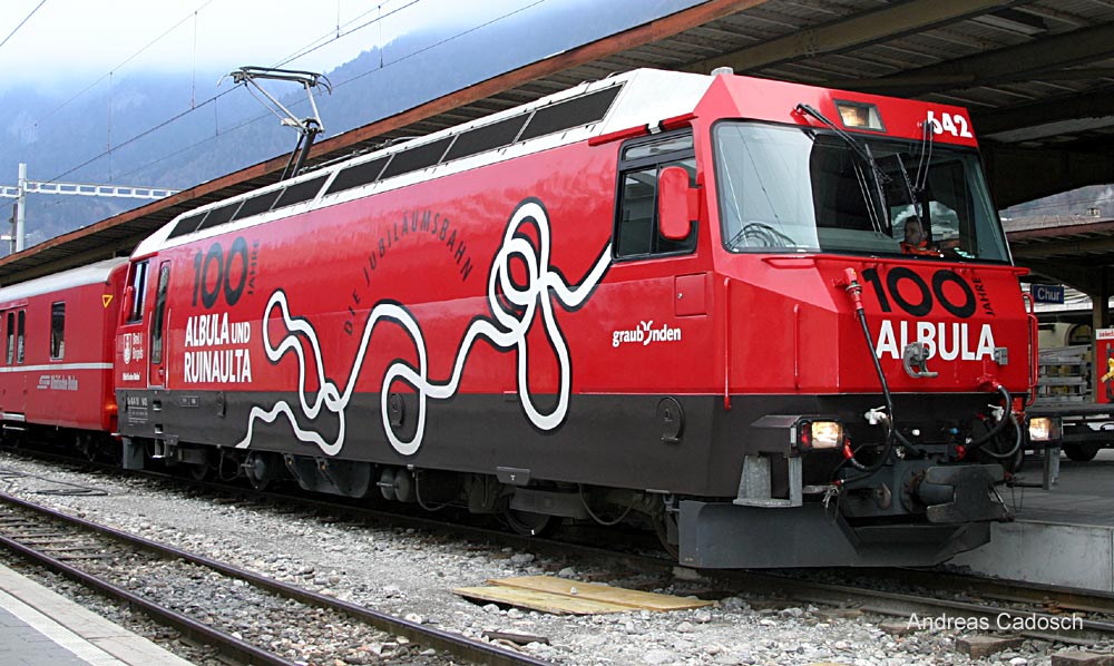
We started up the Albula pass, first riding along the Albula River in the Schin valley to Tiefencastel (851m) and on to the famed RhB railway bridge across the Landwasser, the river that descends from Davos. After diving into the vertical granite wall the railway reaches Filisur (1037m) where the RhB lines split to Davos and St. Moritz.
http://www.ebepe.com/html/albula100e.html
http://www.railfaneurope.net/pix/ch/narrow_gauge/RhB/electric/Ge4_4-III/100_Jahre_Albula/Ge_4_4_III_100JahreAlbula.jpg
From here we rode up the Albula canyon with the RhB zigzagging its way over loops and curved bridges as the road climbs steeply through this narrow valley. As in most of the central Alps, the vertical scale is amazing, often topped by snowy peaks whose names are common in tourist photos that seem like optical illusions for their height and beauty.
As we climbed, various trains went by, including a Glacier Express with air conditioned glass domed cars. Local trains, in contrast, allow opening windows to watch the scenery. Of course by bicycle the experience is more intense, especially in the marvelous weather we had with rain to the southwest and sun from the other side.
http://www.rhb.ch/Glacier-Express.34.0.html
An interesting feature of the railway is that fat tired descending "bicycles", without pedals, can be rented at the Preda (1789m) station, the south end of the summit tunnel, and returned at Berg¸n (1367m), the road being continuously downhill on this stretch. The bicycles have hand brakes, a normal saddle, and a scooter-like running board in the center, looking at first glance like regular bicycles.
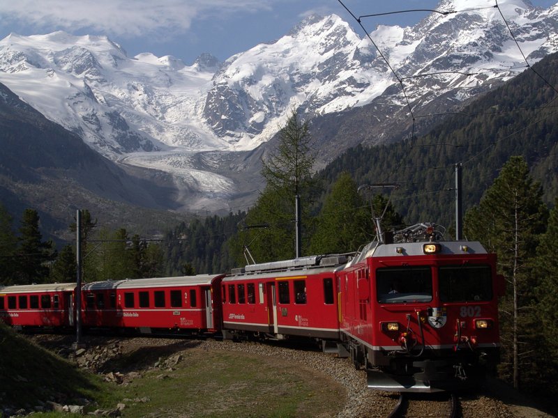
The road climbs higher than the RR to the Albula summit (2312m) after which a brisk descent took us to the Inn Valley at Bever (1711m) we turned west toward St. Moritz, heading south at Samedan (1721m) toward Pontresina and the Bernina Pass. We stopped at the famous Bellavista curve on the RhB railway with its panorama of the Morteratsch Glacier and Piz Bernina hoping to get a picture with a red train climbing the hairpin curve at a 7% grade.
From here the road climbs gradually past the Diavolezza aerial tram that takes passengers to a magnificent view of Piz Bernina (4049m) and Piz Pal¸ (3901m), Piz ZupÛ (3996m), Piz Argient (3945m), and the glaciers that surround them. A short way farther, the Lagalp aerial tram for skiers climbs the other side of the valley before the road begins to climb to the summit lakes. Richard reached the Bellavista curve of the RhB at a better time and got a train in the foreground.
The Bernina (2328m) summit has two lakes, the Lago Nero and Lago Bianco, the black lake with its dark blue waters flowing to the Danube and the Black sea and the white lake with its glacier milk flowing to the Mediterranean Sea.
http://www.trainpics.de/gallery/switzerland/ch-bernina/rb17134.html
http://www.webcam.valtline.it/passoberninag.htm
From the summit, a long continuous descent passes the customs station on the road to Livigno, a duty free zone in Italy, and down through a thin larch forest to the bottom of the hill in the Val Poschiavo (1093m). Passing through San Carlo where the RhB runs through the center of town on a one lane section between buildings.
We rode over the relatively flat Bernina Pass (2328m), took some pictures and descended the long and fast runs down to Poschiavo (1014m) and squeezed through the narrows of San Antonio where the RhB tracks pass between buildings in the middle of a one lane street.
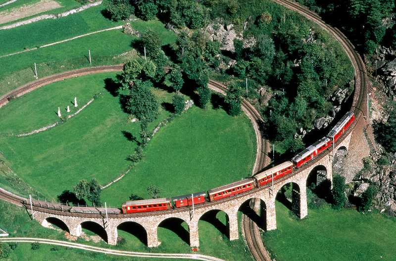
It's a flat run to where we joined forces once more Lago di Poschiavo and Miralago from which we descended to Brusio for a rich lunch with the finest home made ice cream as a topper at Hotel Bottoni, located just above the helical railway viaduct. From there it's a short descent to Tirano and Italy where we rode a kilometer or so down the Valtellina to cut across to Stazzona, the shortcut to the Aprica Pass.
We rode around Lago Poschiavo to Miralago to look back at the magnificent panorama that is often reflected in the reflecting pool of the lake. From here it is a short swift descent to Brusio to Hotel Bottoni, just above the beautiful loop of the railway. We got a good nights rest in spite of the sound of train wheels making the famous curve a couple of times during the night.
http://www.rail-info.ch/RhB-BB/pics/rhb5374.jpg
16. Friday 10 August Brusio - Stelvio 123km 4180m
Under sunshine and billowing clouds we rolled down past the Brusio Loop to Campocologno, the Italian border and mini rail yard in the street to appreciate the European market as we crossed without stopping for a passport inspection. At Madonna di Tirano (430m), we took a right turn down the Valtellina, crossing over to Stazzona , a small village from which a narrow woodsy road climbs to SN39 the Aprica Pass that sweeps up the walls of the Val de Cortena to Aprica (1175m).
From Aprica the road descends gradually to …dolo (690m) after which we passed Monno (1067m), at the north end of the Mortirolo pass that, from my perception has no benefit other than being steep, narrow, and part of the Giro d'Italia, although it is a shortcut from Tirano to Ponte di Legno (1258m) the base of the Gavia pass. We are now on NS42, the Tonale pass route where we made a short visit with my good friend Silvano Macculotti's hotel, the Veduta Dell Adamello in Tem˙.
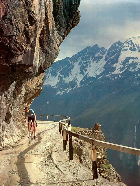
He invited us to stay for lunch, which he was preparing, but being an hour early, we chose to ride on and make sandwiches in Ponte di Legno on a bench next to the roaring Frigidolfo that cascades through the center of this picturesque town. We took the main street, now paved with polished black and white granite tile, that was once the highway, up the valley to Apollonia (1415m) where the Gavia climb begins. The hotel there has been remodeled and looks much finer than when I once stayed there.
I stopped at the gazebo where Apollonia mineral water runs from a spigot. This is naturally carbonated rusty water that is said to give one the power to climb the hill, the hill that was once more of a challenge because it was unpaved and loose in the hairpin curves. We also stopped at the point where the highway department decided to not widen the road but to pave it as is. A collection of intimidating warning signs about the road make a good backdrop for a photo with rider.
We were graced with the wonderful weather that we have had all along, with just enough clouds to keep it cool for the climbs but enough sun to make the mountains radiate their beautiful glacier capped peaks. I stopped at the classic place under the overhang, three kilometers from the summit, where Rick Lyman took my photo in 1987, before a tunnel avoided the exposure.
At the Gavia summit (2621m) we stopped in the Rifugio Bonetta to say hello and check for mail that riders tape to my poster on the wall (under glass). Last year Signor Bonetta had a postcard with that picture made of which he gave me a packet. We got a soda and headed down to Santa Caterina and Bormio, the north side of the pass exposing grand vistas of Pizzo Tresero (3671m), Gran Zebru (3851m), and Ortles (3905m) shining in "more than oriental splendor" as Kipling would say.
In Bormio (1217m) I found the pizzeria across from the Braulio barn had lost its verve. No more crowds sitting in large open windows savoring pizzas from the large wood fired oven. Having gone up-scale like Braulio, the guests were wearing suits. The ancient heavy wooden barn doors are gone as is the smell of hay in the tasting room that was so elegantly set in the ancient building that has been replaced by a chrome and glass liquor store:
http://www.amarobraulio.com/
http://www.viaroma.bormio.it/27/visita.htm
After some food and drink, we headed into the Valle del Braulio to the Stelvio pass that remains the king of all mountain roads in the Alps. I recall asking Signor Cinelli what the greatest road in the alps was, to which he replied, the Stelvio, but you might not like its unpaved east slope. That was a while ago and today the surface is good asphalt although the original avalanche tunnels are still there.
As we climbed to the junction of the Umbrail Pass (2501m) Bob rode ahead as the sky closed to a solid cloud cover. After riding up the Stelvio (2760m) so often the last 48 years, I felt a strong emotional flashback to the many great rides that brought tears to my eyes. I rode non-stop past the summit, stopping at the edge of the abyss in which the road descends the Valle di Trafoi, seemingly straight below, as I stood awhile in euphoria.
Meanwhile Bob had cooled off and decided to take a room for us on the summit which I thought risky because it could be snowing in the morning, the snow line being at about 2800m right now, giving the surrounding landscape in a white coat. I was looking forward to staying in Trafoi. The man who runs the "Hˆchste Wurst in den Alpen" was closing his hot dog wagon for the night and mentioned how we had talked over the years.

17. Saturday 11 August Stelvio - Astfeld 178km 3200m
Well fed, we rode over the top with a good view of the Ortler as we descended the 48 hairpin turns toward Prato (885m) the first big drop being to Trafoi (1543m). Once in the valley we crossed to Spondigna where the Ferrovia della Val Venosta with half hourly two car self propelled trains have good patronage. and cruised down the Alto Adige valley toward Merano in this rich agricultural area that is called Italy's fruit basket with myriad orchards and vineyards.
Disappointing was that this two lane highway had a creeping traffic jam of people escaping the city for what hey hoped would be a peaceful weekend in the Alps. We were fortunate to be going the other way as we rode down toward Merano (302m). The final descent occurs in the narrows from Tˆll past Forst, named after the huge Forst Brewery to Merano. The brewery has a huge blockhouse decorated with their trade mark green pine tree in a huge checkerboard pattern. A wooden bridge decorated with flowers crosses the road from the brewery to their large and beautiful Biergarten.
http://www.braugartenforst.com/deutsch/index.htm
http://www.oesterreichbier.de/?Internationale_Biersorten:Forst_Premium_Bier
We cruised through town and headed north to St. Leonhard (693m) at the base of the Jaufen Pass (2094m) making a pleasant climb over the mountain to Sterzing (948m) from where we turned south to climb the Passo di Pennes (2211m) along the west slope of the Eisack valley, the main arterial for autostrada, railway and highway to the Brenner Pass (1374m) to Austria.
This low traffic road clings to the rocky canyon wall as it climbs steadily to the summit with sections of 13% grades, all the while giving a panorama to the Eisack river and the Dolomites to the east. After the summit, the landscape changes to green pastures, farmland and forest through idyllic villages. I hadn't been this way in years and was pleasantly surprised to find little change.
We stopped in Astfeld/Camplasta (1021m) in the Sarntal of the Talferbach, a comfortable small town in Hotel Greif where I had stopped a few times on earlier rides.
18. Sunday 12 August Astfeld - Marebbe 136km 2948m
From Astfeld it's a gentle descent to Bolzano (262m) through the narrows at the end of this peaceful scenic valley. When I first came here the gorge had 21 tunnels in the west wall of the canyon that seldom saw sunshine, it being so narrow. As skiing became more popular, longer tunnels that cut past these many tunnels were built to improve winter passage so there are about a dozen tunnels today.
As we came out of one longer tunnel, we met a rider on a hand powered recumbent three-wheeler who had just ridden the major passes of the Dolomites. It was apparent that his legs were not functional although he had tights and athletic shoes on his feet. His enthusiasm for "bicycling" was evident and inspiring.
In Bolzano we were back in auto country with typical dense traffic that we soon left behind as we headed up the Eisack valley to the road into the Eggental, a narrow crevasse that drain the west side of the Costalunga Pass. A few years ago, the steep 18% section of this road that clung to the wall and went through short tunnels on its way up the Egga was improved for ski access by a 1.2km tunnel with moderate grades. What was disturbing was the current project to put the entire road through the cliffs in two longer tunnels so there is no more canyon to be seen.
After coming out of the narrows of the Egga comes what is today mostly ski related tourist fare, the summer crowd being about the same number as in years past, although the road has been greatly improved for winter. Above Welschenofen (1182m) we passed Hotel Dianna with a large mural of the huntress in heroic pose:
http://www.diana-hotel.it/grafiken/gross/hotel-00.jpg
A short distance above, the road levels off with a vies to the Latemar with it myriad spires reflected in the Karersee with its azure colored water.
http://www.art-prints-on-demand.comÂÂrtist-artist/latemar-und-karersee.html
Across the road is the Grand Hotel Karezza that was laid waste during WWI & WWII but was finally rebuilt in its original splendor and more.
http://www.grandhotelcarezza.it/eng/storia.html
http://www.consolservices.it/carezza/index.htm
with large indoo swimming pool and spa.
Only at sunset does the Rosengarten truly rise to its famed name although it is a grand mountain, truly in the spirit of the dolomites.
http://de.wikipedia.org/wiki/Bild:Blick_von_Steinegg_auf_den_Rosengarten.JPG
We rode on to Pozza (1320m) where we found a roadside barbecued chicken van with good bread, drink, and salad to go with a half chicken. Well fueled we rode through this magnificent scenery to Canazei (1468m) where the Fedaia and Pordoi pass roads split. We took the Pordoi and turned south to the Sella pass at the next junction.
With puffy clouds in an otherwise clear sky we had no wind and cool climbing air as we ascended the Sella Pass (2213m) to have a panorama to take your breath away. I mad an effort to take five-piece panorama shots with my trusty camera and hear Bob tell me for the third time that this was the most beautiful day of our tour in contrast to the other two, the Val Ferret and the Via Mala.
I couldn't argue. When I first saw these places the roads were unpaved and traffic scarce. The only bicycles seen in those days were during professional races. I recall that I suffered for lack of sun glasses then, going snow-blind on the powdery white dolomite road.
We rode down to (1800m) to take the Gardena Pass (2121m) and descend to Corvara (1568m) the home of the Alpini, the mountain warfare troops, Italy's equivalent to th U.S. Marines. From here we headed north to Zwischenwasser (1005m) and head up toward Peder˙ where the steepest road in the dolomites goes to a former military site. We stopped in Marebbe (1193m) with excellent food and lodging where we happened upon their regular Sunday before dinner hors d'oeuvres and champaign and ate to much of each, it was so good.
19. Monday 13 August Marebbe - Brixen 116km 1172m
After an early breakfast, we continued up the valley to Peder˙ (1548m) at the end of the road. Here, on the other side of a rail fence were four-wheel drive taxis of various types that could hired to climb these steep military roads from the last war. Most of the visitors chose to hike using poles to prevent falling on ones face in the event of a slip on the loose road.
The road zig-zags up the wall in a roughly 30% grade with hairpin turns that are 100% on the inside, now all paved with ribbed concrete. We posed some shots pushing our bicycles up the inside of turns but in the end it was strenuous hiking. Leveling-off came at rifugio Fodara Vedla (1972m) where we could have taken the direct route toward Cortina but we continued up to the former airstrip and Rifugio Sennes where food and comfortable lodging is offered. I settled for an ice cold half liter of Coke.
Being Monday the crowds that I experienced playing football (soccer) on the airstrip were not there but the grass was green and kept short by grazing sheep. The descent wasn't as steep as the ascent but it was loose rock and steep enough to make walking difficult in sections. We were amazed at an MTB rider, in his lowest gear, grinding up this road. The last time I rode down here I met a FWD heating oil tank truck coming up, driver and copilot watching carefully where the edge of the road was.
After reaching the gate that keeps the public from losing their cars farther up, the road was still steep enough to give concern about braking heat. We joined highway N51 (from Cortina to Dobbiaco) at a hairpin at (1400m) as we followed the old railway right-of-way that served Cortina, cresting at Cimabache (1529m) on the way to Dobbiaco/Toblach (1241m). Here we got on the main highway N49 between Brunico/Bruneck to Lienz heading west.
We should have taken the train in Bruneck but continued the gradual descent to Bressanone/Brixen (559m) from where we took the train to Innsbruck and Landeck for lack of time, time that we lost from being sick in France and slower progress thereafter. We got a hotel in Landeck (816m) and got some rest for our hiking legs that seemed more tired than from the hiking passes in France. It could be the downhill work that made the difference.
20. Tuesday 14 August Landeck - Urnerboden 219km 2600m
Landeck is at the foot of the Arlberg highway and railway where we usually take the Silvretta road over the Bielerhˆhe, but as we headed up that road we ran into heavy rain just before See (1000m) and turned back. This was another opportunity to ride over the Arlberg Pass (1793m) a road that I hadn't seen in many years.
On the way we noticed that the railway was not running and that track work was going on in many locations. We stopped to watch a rail joint being welded using the thermit process, something I hadn't witnessed in many years. As we got to St. Anton (1294m) where the railway takes the tunnel and the road becomes steeper with 12% grades off and on, we saw the rain falling on the south side of the valley and beyond.
We rode in partial sunshine down to Feldkirch (455m) and turned south into Lichtenstein where we crossed the Rhein river on the old wooden bridge for pedestrians and bicycles to take the bicycle route along the west levee to Sargans (483m). We found the bicycle path down the creek to Walenstadt (427m) on the Walensee and rode to M¸hlehorn where the shortcut over the Kerenzerberg (700m) cuts over the hill to canton Glarus in N‰fels (445m). We rode up the valley past Glarus ti Linthal (667m), the end of the SBB rail line where the road cuts into the wall of the box canyon, and climbs to reach the high valley, Urnerboden, that belongs to Canton Uri that lies on the other side of the pass.
Now it looked like the rain was close by and let a drop fall once in awhile. Bob was ahead as we reached Urnerboden (1372m) and found a room in the only hotel open up here. I arrived at the hotel just before the sky broke open and dumped heavy rain as we got to our room and prepared for dinner. Meanwhile, I called my friend Steffan Truschner in Urigen over the pass to tell him we wouldn't male it to his place today, upon which he told me the sun was still shining on the other side of the pass.
21. Wednesday 15 August Urnerboden - Alpnachstadt 197km 2810m
In the morning all was washed clean but herian and the sun was out in full force irf not steaming hot. From Urnerboden, the road gently rises to Port (1372m) before once more climbing a rock wall up to the Klausen Pass (1948m). The upper part of this pass is spectacularly scenic as it passes through the U-shaped Urnerboden and climbs the granite walls at the head of the valley. My experience has always been that the mountains look extra high here because their tops seem to always vanish in clouds. Today was no exception.
The top of the pass is fairly flat and starts its descent gradually as a glorious panorama to the north opens underscored by the Sch‰chental, a box canyon that drops off precipitously, shortly after the summit. The road clings to the edge passing through rough rock tunnels as it gives vertical views of roofs of farm sheds nearly straight below as the Sta¸bifall traces its route from the glaciers of the Tˆdi (3620m) to the lip of the canyon from which it free-falls and is blown to mist before reaching the ground thereby earning its well deserved name.
We stopped at Posthaus Urigen (1200m) for a morning pastry and a hello to Stefan and Karin Truschner who own and operate the hotel. Their daughter, JoÎl, is about in her her teens, reminding me how many years I have been stopping there. As we got ready to leave the Postauto came up from the valley sounding its famous three tone bugle salute, the essence of swiss mountain roads.
After a short dash to Spiringen (995m) in the Sch‰chental, there is a little climb before the stretch down to Altdorf (458m) where William Tell and son stand in the center of town.
http://www.tell.ch/schweiz/telldenkmal
We turned up the Gotthard route to climb to Wassen (916m) with the little church that is seen three times from the train, once above, then next to the train and then below, each time traveling in the opposite direction on elevation gaining loops that will one day be in the past for through trains as they use the new 52km base tubnnel.
Here we headed north into the Meiental through the granite walls with curved tunnels and roaring waterfalls to get on the main climb of the Susten Pass road. The riad is one of the newest alpine passes (other than autoroutes), completed in 1948, and therefore has a uniform 8% grade most of the way, something that is a bit dauting, there being no rest zones that are flatter.
Just the same, I always look forward to the small restaurant at Felsenegg (1613m) where I stop to dring a large soda before making the last zig-zags up to the summit tunnel. At the top, the Susten (2224m) was crowded with bicycles, fat and thin tired, and the cafeteria was busy. We took in the splendid view of the Sustenhorn (2974m), Damastock (3630m), Dichterhorn 3389m) and many others that made up the glistening white panorama above the Steingletcher that ends in a lake at Steingletcher 1863m), 360 meters below where we were standing.
The descent to Inertkirchen (625m) went with little traffic on a dry road. From here it was old territory as we climbed the four legs of the Kirchet pass (786m) to Meiringen (592m) to climb the Br¸nig pass (1008m) and cruise down to the Lake in Alpnachstadt (440m) wher3e we stayed n the Hotel Rˆssli near the Pilatus cog railway, the steepest using a unique horizontal rack with double side angagement.
http://de.wikipedia.org/wiki/Bild:Pilatus_Zahnrad.jpeg
22. Thursday 16 August Alpnachstadt - Ibach 10km 200m
In the morning we inspected the Pilatus railway and caught a lake steamer that took us to B¸rgenstock where we changed to a connecting steamer to Brunnen. There are five of these classic sidewheeel steam boats with an exposed engine room in which huge connecting rods on a giant crankshaft turn the paddle wheels. All the machinery is spotles and painted bright red with metal trim.
The fleet of five:
http://www.lakelucerne.ch/index.cfm?site=schifffahrtvierwaldstaettersee.ch&page=12&lang=D
There is a plan to repurchase the William Tell steamer, that has been operated as a floating restaurant in Lucerne, to re-join the fleet to make six steamers. >From Brunnen we rode the ten kilometers back to Ibach.
Many of the places mentioned in this report can be seen at:
http://www.paloaltobicycles.com/alps_photos.html
| 1. | Thursday | 26 July | Ibach - Rosenlaui | 102km | 2776m | |
| 2. | Friday | 27 July | Rosenlaui - Hospental | 138km | 3000m | |
| 3. | Saturday | 28 July | Hospental - Biella | 236km | 1572m | |
| 4. | Sunday | 29 July | Biella - Ivrea - Tenda | 96km | 1508m | |
| 5. | Monday | 30 July | Tenda - St. Etienne | 150km | 3332m | |
| 6. | Tuesday | 31 July | St. Etienne - Arvieux | 111km | 2304m | |
| 7. | Wednesday | 01 August | Arvieux - Lanslebourg | 140km | 2915m | |
| 8. | Thursday | 02 August | Lanslebourg | 0km | ||
| 9. | Friday | 03 August | Lanslebourg | 0km | ||
| 10. | Saturday | 04 August | Lanslebourg - Bourg St. Maurice | 80km | 1480m | |
| 11. | Sunday | 05 August | Bourg St. Maurice - Lavachey | 131km | 3236m | |
| 12. | Monday | 06 August | Lavachey - Brig-Ried | 137km | 1100m | |
| 13. | Tuesday | 07 August | Brig-Ried - Bignasco | 146km | 2368m | |
| 14. | Wednesday | 08 August | Bignasco - Thusis | 158km | 2260m | |
| 15. | Thursday | 09 August | Thusis - Brusio | 110km | 2468m | |
| 16. | Friday | 10 August | Brusio - Stelvio | 123km | 4180m | |
| 17. | Saturday | 11 August | Stelvio - Astfeld | 178km | 3200m | |
| 18. | Sunday | 12 August | Astfeld - Marebbe | 136km | 2948m | |
| 19. | Monday | 13 August | Marebbe - Brixen | 116km | 1172m | |
| 20. | Tuesday | 14 August | Landeck - Urnerboden | 219km | 2600m | |
| 21. | Wednesday | 15 August | Urnerboden - Alpnachstadt | 197km | 2810m | |
| 22. | Thursday | 16 August | Alpnachstadt - Brunnen | Lake steamer | ||
| 2704km | 46738m | |||||
After a couple of weeks on a Eurail pass visiting friends...
Return:
Part I:
AC879 Zurich (ZRH)
Fri 31-Aug 2007
09:15
Toronto, Pearson Int'l (YYZ)
Fri 31-Aug 2007
12:10 - Terminal 1
Part II:
AC755 Toronto, Pearson Int'l (YYZ)
Fri 31-Aug 2007
15:40 - Terminal 1
San Francisco, San Francisco Int'l (SFO)
Fri 31-Aug 2007
18:05 - Terminal 1