 Claire and I looking happy!
So taking advantage of the ferry transport, we slipped away for the weekend to the Calvados Region of Normandy.
Claire and I looking happy!
We have been to Normandy before, on similar tours. So much so, the initial part of the route is referred to (by us) as the "route de Lambert", after my friend Alan Lambert, who introduced me to cycle-touring.
In particular, the part of this region known as the "Suisse Normande" is particularly suited to cycle touring (at least by us) - the area is picturesque, (the river, the forests for example), has a number of interesting villages and towns, is quiet at this time of year, has enough ups and downs to be interesting and still easily managable. The food is pretty good, and affordable. And we know it quite well by now!
We had a little AA guide (the motoring association), which was not much use (as can be expected); next time we'll get the Rough Guide.
On the boat back home, we picked up a camping guide for the region, as well as some less than useful brochures. If only we had spotted the camping guide on the way out.
As well as the Michilen yellow series map 1:200 000 (which we had from last time), we bought the IGN Series Verte map (No 18: Caen-Allencon). Not essential, but at 1:100 000 it has contours (so you know what you're in for), and makes finding the small roads a little easier. (Now I find that we bought this map last time we went, so now we have two!)
Taking the bikes on the ferry, we left the car in England. We took the tent, sleeping bags, a change of clothes (for the evenings), a few tools, the corkscrew, and some old picnic plates/ cups.
And at the Thomas Cook in the ferry terminal, we got some French "food and wine vouchers" (i.e. cash)!
But it's a great feeling to cycle past the cars queuing to load, and ride onto an empty car deck (soon shattered as the car deck quickly fills with noisy, smelly cars!)
A couple of beers, a bit of chat to one of the motor bike riders who seems to commute between London and Brittany, and then bed.
As I hate getting up (too) early, we skipped breakfast on the boat, but we were up and ready to roll as the boat unloaded.
We didn't quite hit the optimum route out of Ouistreham,but we were close (the cars go down the fast dual-carriageway - definitely to be avoided!)
By 6:45 we were cruising along the river bank, with a mist hanging over the river, and only a few locals doing a spot of early morning fishing. We lost the other cyclists who were on the boat with us almost as soon as we landed, and didn't see any of them again until we rejoined the boat 3 days later.
This run along the river bank is a great way to begin - effectively a bit of a warm-up for the weekend.
By 8:30, we were having breakfast - a coffee and croissant - at a cafe on the footpath in Caen, just as the sun was starting to warm up a little. (We spared a quick thought for our colleagues who would be worrying about getting the bus or tube for work!).
Refuelled, we hit the "Route de Lambert". This is really known as the "Route Touristique de la Vallee d'Orne", which follows along the west bank of the Orne river - not actually along the river bank, but to all intents parallel to it. Thus the ride has some gentle-ish ups and downs to it.
The run was quiet - only a few locals going about their business.
It was too early for our traditional beer stop at Pont de Coudray (on previous occasions we'd ponced about in Cean - looked at the castle, the Marie, etc, and arrived at Pont de Coudray at beer time), so we carried on. A quite sharp little hill up out of the valley met us from the bottom of the river valley (~30m) up to Trios Monts (146m). At one farm house we passed here, the sheep were standing on the steps of the house, looking as though they wanted to go in!
However, arrival at Thury-Harcourt (26m) was definitely beer time (11am), at one of the bars in the main street. The locals were deep into some discussion or other - probably revolving around the scratch-card lotto, or the horse racing - but it could have been the then forthcoming presidential election for all we knew.
Lunch was procured from the local supermarche, and consumed beside the river (gate-crashing a spot which is the preserve of the local canoeing and kayaking club). Eventually (around 14:00) we set off again.
We were then climbing (well a gentle, but steady up, rather than a climb), out of the Swisse Normande landscape into more open farmland (but with a bit of forest), through the village of Combray, to the highest point of the day, St Clair (at 306m).
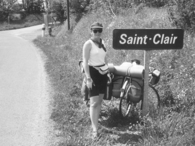
Claire had to stop for a picture (and pretend that if she could be a saint if she misspelt her name!)
The decent is quite quick (even after an unintentional detour through St Omer - no map reading marks for me), down the double chevrons of the Michelin map, right to the bridge at Le Vey, where the familiar Clecy campsite is.
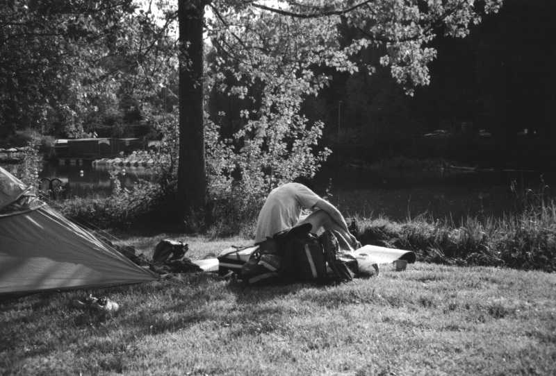
This campsite is quite small, but right on the river. And we pitched our tent close to the river edge, from where we could watch the locals fishing in the weir. We were pleasantly surprised to find a limited amount of refurbishment of the facilities, and also relieved to find they still sold the local farmer's cider!!
After a bottle of cider between us, planning the route for the next day probably wasn't the ideal thing to do next!
Dinner was in one of the restaurants by the river (opposite the campsite), and good it was. As was bed.
Off into Clecy, for coffee, water stocks, postcards and the obligatory pics.
Another pleasant start to the morning, round through le Bo, towards Pont-d'Ouilly. Just before reaching Pont-d'Ouilly, turned east, following parallel to the bigger road D511 towards Falaise, but keeping (for the most parts) to the small roads (via Pierrepont).
We reached Falise (132m) for the supermache stop, and lunch in the grounds of Chateau de Fresnaye, watching the local pony club going through its paces.
From there north-east through Damblainville, following the rivers Ante, and then Dives north. A beer in the cafe de la gare at Vendeuvre - it was pretty hot at this time, and the cafe owner and his offsider joined us, having finished some manual work.
We were pretty relaxed, as we rode into our intended overnight stop of St Pierre-sur-Dives (32m), arriving at around 16:30, and stopped for perhaps an hour enjoying a beer, watching the antics of the locals on a warm Saturday afternoon.
Then we cruised around to the campsite, to find that it was closed, and didn't open until around 1-July. Although there was plenty of space, the water had been turned off, so sneaking in would have been pretty uncomfortable.
So some quiet bad language directed at whoever operated the campsites, and then the French in general for their idiotic holiday habits (the whole country going on holiday for August, and no-one any other time). When more logical thought processes reappeared, a quick look at the map revealed a campsite at Lisieux, within striking distance (25km).
So off we struck. (Along the D511, via St Julien-le-Faucon).
As time was short, we kept up a faster pace, and perhaps stopped less. However, we did have one stop, where Claire looked less than enthusiastic about life!

However, we kept on, and rolled in to the campsite (which was open, and not even closed up for the night) at 19:30.
The campsite is about 2 km out of the town centre, and so provided a pre-dinner stroll. Dinner was again good.
About here I was surprised whilst cruising along by a local cyclist out on his Sunday morning run; the first I knew of him was when he said hello (salut) when right beside me!
The morning "beer stop" was in Beuvron-en-Auge - a picturesque little village. As it is also on the "Route de Fromage" it was no surprise to find quite a few tourists wandering about (not many having arrived on bicycles). We were tempted to stay there for lunch, but we carried on to the coast, following the D49 north to Dives-sur-Mer and then Houlgate, and avoiding going over the ridge immediately behind Houlgate.
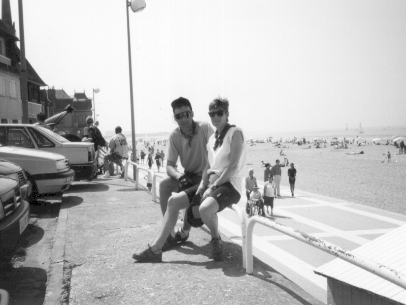
Lunch was at tables outside the cafe on the footpath, and fishy (we were at the beach). And good.
And we paused for a photo (well, we were at the sea-side!). The beach was pretty busy, being Sunday, so we didn't hang around after lunch.
We were well and truly on the homeward leg - a busy road just behind the beach through Cabourg and Merville-Franceville-Plage, before turning off southwards towards Ranville. As this was just behind the beach, there were quite a few more people on bikes, who were probably at the beach, and were going for a bit of an outing.
We met the river Orne at the Pegasus bridge, but what a change from 3 days earlier. At 07:00 on a friday morning, there was mist above the river, the little cafe was closed, and there was one or two fishermen about. At about 16:00 on a sunny Sunday afternoon you couldn't get into the cafe for people, and the path along the river was busy with bikes, people fishing, families, kids, etc. The river itself had a number of water-skiers, and someone zooming round in circles on (and falling off) one of those jet-ski things, making an incredible noise. (should be banned!)
When we got to Ouistreham, tempted as we were to find a beer/ice cream immediately, we went straight to the campsite, to get setup there (don't say we're not quick learners!). No drama there, so into town for a beer. The town was heaving (busy); there appeared to be some sailing event in town, with the various crews stopping for beers/ food. There were also people waiting for the evening ferry, and the local fish market in full swing. We found a couple of cans of beer in a little "corner shop", a bit away from the port area, which we had back at the campsite (with the background noise of that person on the jet-ski!).
Dinner was in the town, just away from the main port area. The place was busy (same people waiting for the ferry, and yachting people from the boats. (No need to speak French here).
Off the boat in time to find a pub for lunch (by car), and home for the VE-day celebrations.
However, Alan has since moved to Holland, and tends not to do much bike touring. He says it has something to do with cycling being a way of life in Holland taking away the pleasure of touring. But maybe his new baby has more to do with it, or he's just getting old!
Come off the boat, head south. At the lights out of the ferry terminal, go straight ahead (and south). At the next set of lights (about 50m further on), turn left, towards the lock (Eglise). Then right just before going onto the lock, and follow the road south, along the river bank.
After about 0.5 mi, past a boat yard, the road turns slightly right, towards a big (nasty) roundabout. At this point, veer left, onto a paved area behind a wharf-bit (probably with boats tied up), and continue down the path alongside the edge of the river (what would in the UK be the tow-path), all the way to Caen. Stop in Caen for coffee, or beer, as appropriate.
Other cyclists we talked to on the ferry back stayed the last (Sunday) night in Ranville, and had dinner at the restaurant on a boat/barge floating on the river, next to the Pegasus Bridge. That left them with a 2 mile cycle up the river early Monday morning, to catch the ferry. Possibly a better option than the one we took, as Ouistreham was pretty busy, and the campsite was a bit big for my taste (I seem to recall they had run out of hot water!). We might try this next time. But the preffered option is to get the afternoon ferry, stay a morning's ride away, and have lunch close(ish) to the port.
Duncan Snelling