From Sevilla to Granada: a trip through Andalusia

by Markus Sauer and Ute Dasburg
All material is
by Markus Sauer and Ute Dasburg
All material is
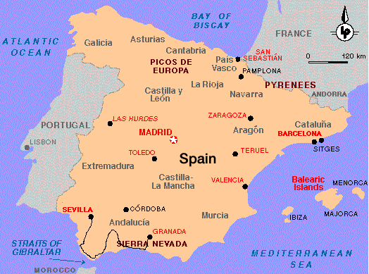
This is a report about a bike tour which we undertook in Andalusia in September '95. We started in Sevilla, travelled down to Tarifa at the Strait of Gibraltar, learned a lot about forceful winds, crossed the mountains of the Serrania de Ronda to see Ronda, one of the oldest cities in Spain, directed our tires once again to the sea side towards Malaga, travelled on lonely winding roads and the beach promenades of the Costa del Sol and finally crossed the Sierra Nevada to terminate our journey in Granada, one of the most beautiful cities we've ever seen. The overall distance was about 700 km. We took two and a half weeks but think one should have a week or so more to fully enjoy the spirit of the region.
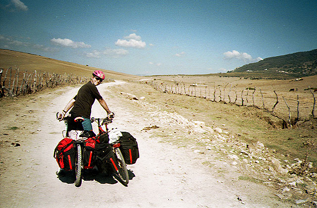
Traffic. Although Andalusia is supposed to be one of the less developed parts of Spain, there is a lot of traffic. However, there were'nt any problems neither with car nor with truck drivers. The air pollution caused by the traffic, on the contrary, is sometimes a problem. One should account for this already in the early stages of planning. Road conditions are very good as compared to - say Portugal (see our report about a Bike tour in Portugal). Touring bikes or race bikes are o.k. on these roads. For those addicted to off-road adventures, the best opportunities seem to be the Serrania de Ronda and in the Sierra Nevada as well as in the region north of Almeria.
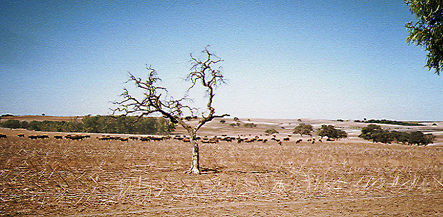
Geography. In the more western region, say between Sevilla and Tarifa, Andalusia is quite flat. Then, the mountains begin, and they become higher and higher the more eastwards one moves until the Sierra Nevada is reached. Here, the highest mountain in continental Spain, the Pico de la Veleta, is situated. Especially on the stages between Tarifa and Granada many hills have to be climbed.
Climate. We made the trip in the second half of September. Temperatures are reasonable at this time of the year. Of course, there is nearly no rain in Andalusia except the region around Ronda which is quite famous for the fruitful climate.
Near to the sea side and especially in the region around the Strait of Gibraltar, one should be prepared to strong winds blowing from the sea side towards the country.
Remarks. The details about the distance (DIST) and altitude differences (ALT) climbed are only estimates. We tried to be as precise as we could, but don't take these data too serious. Of course, for the altitude differences we counted only the climbs, not the downhills.
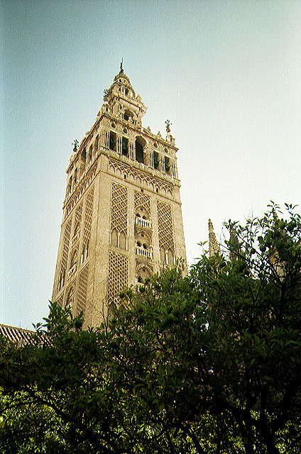
Why go there ? The scenery is unique. The semi-arid shores and mountains of Southern Spain invoke incomparable impressions even if the region cannot be termed paradisiacal but should sometimes rather be called 'extreme' and desert-like. Africa is a stone's throw away and this is really impressing. The region is a living testimony of Europes culture and history. It was reigned for hundreds of years by the Arabs who have left their signs in cultural monuments of uncomparable beauty as the Alcazar in Seville, the Alhambra in Granada but also in sophisticated agricultural techniques which partly have survived in the terrace cultures of the Alpujarras. Nowadays, when the Islam is getting stronger and Europe interprets this as a menace, a look at the Islam's former influence on the culture of our continent can give way to a more deliberate consideration of this situation in terms of a dialogue rather than a rivalry.
Other resources:
On the Web:
LonelyplanetThe Andalusian Tourist Information Network
Printed:
The Andalusian government is the editor of a very comprehensive Mountain Bike guide which describes 120 tours all over Andalusia. It is also available in English and is definiely worth its 'prize' - if one can tell 400 Ptas (roughly 2.5 US$) a prize. Should be available through your local embassy or through: Turismo de Andalucia, Autovia Sevilla-Coria del Rio, km 3,5, Apartado de Correos 66, 41920 San Juan de Aznalfarache, Seville, Spain. Phone: 34 5 417 11 60, Fax: 34 5 417 12 78 Organzed trips: (if you know of other agencies organizing trips in Andalusia, please drop me a line) Spain: Almeria Bike Tours: +34 50 27 70 28 Germany: Alps Mountain Bike tours: ++49/89/542 78 80 Bike Alpin: ++49 9176/5478 Velo Travel: ++49 721 / 252 44 Extrem Emotion Sport Tours: ++49 /8704/ 921530
1. Day: Sevilla Airport- Sevilla. DIST: ca 15 km
The only connection between Sevilla and the Airport is
a four lane highway. There are no means of public transport between the
airport and the city.

4. Day: Sevilla - Jerez de la Frontiera DIST: 127 km, ALT:500
We started in the early morning since we knew it would
be a long day. We sat on the bikes at nine o'clock. The morning sun shed
a warm orange light on the city which still seemed to sleep. On the main
road heading south there was nearly no one but us. Outside the city, the
main road transforms into an highway which serves all the traffic leaving
from Sevilla southwards. Really boring. However, there is a shoulder in
a good condition which can be used by bikers. At Bella Vista we left it
to turn towards Utrera. Still the peaceful atmosphere of an early sunday
morning. Just a few small hills in that region, small towns. Large grain
fields, already harvested at that time of the year. Pollution began to
be a problem behind Dos Hermanas. Road 432 is frequently used. Coughing
we entered Utrera to have a rest. A nice little town with a rural charme.
From there we tried to find a tiny road signed in our map which should
connect Utrera with Cortijo Nuevo. Nobody of the locals seemed to know
about it. We searched for it for quite a while, then decided to take the
road towards Los Palacios (very quiet). What a mess ! If we had known this
before, we could have taken the direct road from Sevilla. At Los Palacios
we had summed up a detour of 20 km. We took Road N IV until Cortijo Nuevo
(nearly no traffic at that part - and at that time, more or less at noon).
At about two o'clock, no cars on the street. There was only the southern
sun breeding on the land. No trees, no shadows.

5. Day: Jerez de la Frontiera - Vejer de la Frontera DIST: 70 km, ALT:
We rose late, too late to profit from Jerez' rich distilling
industry (I still feel today that this was a pity). The city made the impression
of a prosper, well-organized unit without much attractions other than taking
a look at the daily life of the inhabitants (and the above mentioned industry,
of course). On road 440 one first passes the central stock of Domecq (no
degustation) and then an old monastery (La Cartuja, no visits possible).
With these disappointing experiences in mind, we headed towards Medina
Sidonia. Finding the way to get there is quite confusing due to recently
built roads and our map which wasn't too precise. Medina Sidonia is situated
on the top of a solitary steep hill. About 150 m to climb, but it's worth
a visit. There is a beautiful central square with a view on the old castle
and the near-by restaurant serving delicious tapas. In the afternoon on
the way to Vejer once again strong winds from the front. While the first
part of this stage was characterized by a wide and long scenery,
6. Day: Vejer de la Frontera - Zahara de los Atunes - Tarifa DIST: 61 km, ALT: 300 m
We left Vejer after a long walk through the town. The
200 m which we had to climb the evening before with already tired bones
turned now into a welcome start for today's stage. The road winds through
pine forests down to Barbate da Franco from where it continues all along
the flat coastline until Zahara de los Atunes. Today, the wind was our
friend. Still blowing from the west, it gave us a slight push from behind
and made the ride a joyful travel. Zahara is a little charming fisher town
with endless beaches and only a few hotels. The few tourists seemed a little
bit lost in this almost sleepy town. There is something like a Grand Hotel
there, where we ate the best tuna steak ever in our lives and enjoyed the
silence of the place. At Zahara one has to leave the beach road because
somewhere afterwards it enters a military region which does not allow access.
We decided not to take the regular road towards La Zarzuela because this
would have meant a roundabout way. Instead, we took the unpaved farmers roads towards Molino del Moro and El Acebuchal.
7. Day : rest
8. Day: Africa (... by ship)
Tarifa is conneted with Tanger by a pretty fast ferry connection- it takes about an hour to cross the Strait of Gibraltar. We thought we should't miss the experience to pass one day in Africa and especially in Tanger ( a mystic place where east meets west - think of Paul Bowles, W. Burroughs... ). When we asked for the boarding times we were persuaded to book a guided city tour which costs only a little bit more than the regular ferry price. There were also some rumours around about people who had intended to visit the city as individual tourists and who were not allowed to enter, being closed all day in the harbour facilities. Well, don't know if these were just rumours spread to make the tourists book the guided tour... Telling it shortly: we made a trip with the bus (was okay, got quite a lot of impressions) and were then guided through a part of Tanger which seemed to be set up exclusively for tourists. There were the snake-charmers, the native music band who seemed to start playing only when Europeans where around, we ate in a typical restaurant (where about 100 other tourists were served) watched the inevitable Suleika delighting us with the belly dance and finally found ourselves caught in a carpet selling show. No occasion to spend not even a minute on our ownes - if you like to see Tanger, go there without booking the tour.
9. Day: Tarifa - Castellar de la Frontera - Jimena de la Frontera DIST: 83 km, ALT:600
From Tarifa to Algeciras leads a quite frequently used
main road which rises up to a mirador in about 300 m altitude. From there
once again a breath-taking view on the Rif mountains, the Gibraltar rocks
and of course the Strait. A refreshing downhill continues all the way down
to Algeciras which is the lively commerce and industry center of the region.
Some kilometers northwards at San Roque begins one of the most beautiful
stretches of the trip - this applies to all the way up to Ronda. We took
Road 3331 (peaceful) towards Ronda through a green valley with charming
little towns. Following a suggestion of our guidebook we decided to climb
the 200 m up to Castellar de la Frontera, a little medieval town abandoned
by the inhabitants and now populated by (a special kind) of artists. The
road leads through a wonderful forest region, but the steep rocky hill
we had to climb at the end made us regret our decision. The view from above
there is unique of course, it's the highest hill in about 20 km distance,
the old castle is interesting and the people up there are nice - they seem
to be primarily devoted to the art of living rather than to the fine arts,
though. Well, if you have strong legs and carry few luggage you might appreciate
to pay them a visit. By the way, the narrow road leading towards northeast
is apparently unuseable. You have to take the same road back to Nueva Castellar.
And just another thing: Spain is getting dry as does the 'Embalse de Guadarranque'
which is marked in the maps as a huge artificial lake.
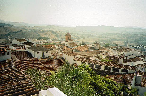
10. Day: Jimena de la Frontera - Ronda DIST: 65 km, ALT:1200 m
After taking the bath, we left Jimena at about noon. At
the town exit, there seems to be also a public pool. We began to climb
the 400 m up to Gaucin which turned out to be demanding: we had to climb
on a southwestern slope during noon on a sunny day. The view on the farmland
around compensated us only incompletely for these efforts.

11. Day: rest
12 Day: rest
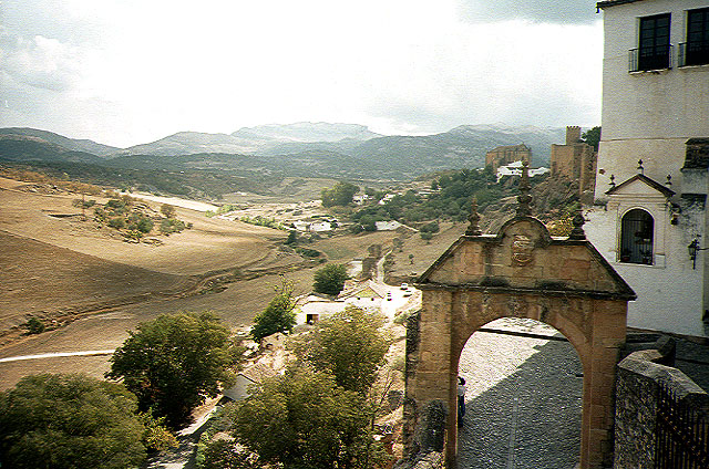
13. Day: Ronda - Estacion de Cartama DIST: 96 km, ALT:400 m
A rough day which gave us a slight impression of what the central areas of Spain must be alike. Our final destination for this stage was Malaga, and the best way seemed to avoid Route 344 from Ronda to El Burgo. There are three passes on this road and it is much easier to take Road 341 northwards towards Campillos and then right before the Embalse del Chorro to turn south via Ardales to Alora. The road is mostly downhill until the Embalse ( needless to say that it didn't carry water) and we enjoyed the first thirty kilometers of it. Then a strong wind arose ( of course it was blowing from the front, what do you expect ?). Well it was more like a storm and cycling continued to be exhausting. Here, the scenery turned from the varying mountains of the Ronda region to wide plain farm land. The land was harvested and for miles one could see the red soil and the pale yellow stems of grain. Hardly a house to see. Right before the Embalse there is a truck stop where we ate something and watched the wind blowing sand and grass across the land. The rest of the day was a torture. The wind continously blew from the front with a strength we wouldn't have imagined ever before. It was difficult to drive under these conditions. When we reached Ardales we were quite desperate. Only the hope to encounter a long downhill after the pass near Carratraca made us continue. In fact, after Carratraca the road goes in downhill all the way to Malaga. I think it might be 600 m altitude down there. But ... believe it or not, the wind was blowing so strongly uphill that we had to pedal all the way down. The road was so inclined that without the wind one could easily go at a speed of 40 km/h. The bikers cycling uphill seemed to have approximately the same speed as we had. I nearly went crazy, Ute tried to calm me down- without success. We were completely exhausted when we reached Cartama and realized that it was too late to go to Malaga this evening. We took a room in Estacion de Cartama ( there isn't really anything there which would make it interesting), crossed the street to take the diner, stumbled back and fell asleep.
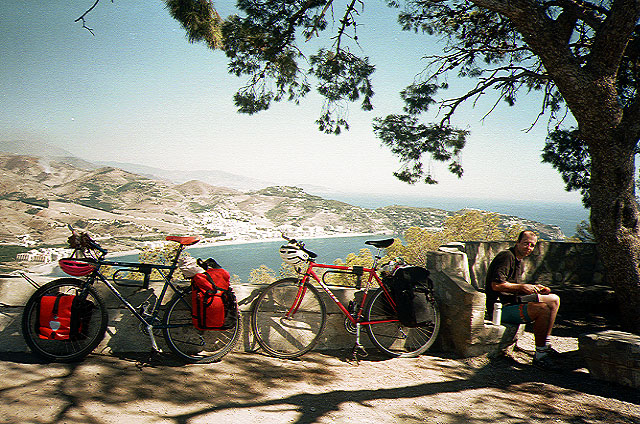
14. Day: Estacion de Cartama - Nerja DIST: 79 km, ALT: 400 m
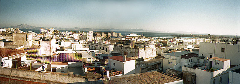
The region around Malaga is quite crowded; probably there isn't any way to avoid the traffic if you want to visit the city. However, the city is quite nice and it is better than it is made out to be. The parks and promenades are not as spacious as those in Sevilla, but it has its own special atmosphere and it is by far not as distinghuished as Ronda would like to be. There are some cheap and good restaurants at the easternmost part of the beach promenade. The coastroad E 15 of course is very crowded, but one can get along quite reasonably on the beach promenades and the old road which is partly conserved. Costa del Sol, too, is better than one would expect it to be. There are a number of strange urbanizations in terrible 'Saracene' style and on many parts the coast is absorbing more tourists than it should, but alltogether we enjoyed that part of the journey. Nerja is such a place where crowds of tourists meet in hundreds of bars, shops and restaurant. Quite a hectic town. The western part of it is newly built with big buildings; most of the hotels are situated in the eastern part. The town center around the 'Balcon de Europa' offers a wonderful view on the steep hills of the Costa del Sol and this is what makes the city worth a visit. After sunset the lights of the boats and the surrounding villages twinkle over the water. O.k., it's normally not the way I would put it in words, but: it is romantic.
15. Day: Nerja - Velez de Benaudalla DIST: 61 km, ALT:ca 600
We failed when we were looking forward to a relaxed day
on the bikes thinking that we just had to follow a coast road without major
climbs or descents. Actually, the road rises several times a few hundred
meters. The most beautiful part of the day was when we used the old road
somewhere between Nerja and Almunecar. By the way, there are two tunnels
on the main road which can be passed by on the old road. For some kilometers,
it leads through the pine forests of the steep coast and one encounters
just a few cars if any. On top of this road, covered with trees there is
a point called Cerro Gordo, one of the most wonderful places where we ever
have been.
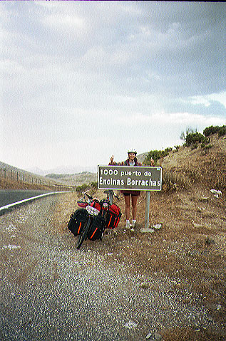
16. Day: Velez de Benaudalla - Granada DIST: 55 km, ALT: 800 m
Sospiro del Moro is the easiest way to pass the Sierra
Nevada, but the road we chose to get there is also the most popular one.
There are no steep climbs, but the road is continously in uphill on the
south face of the Sierra; the region is accordingly hot and dry. The many
trucks were not much of a problem physically - the shoulders and the width
of the road avoid greater problems. After Durcal, the road rises less steeply
and one is tempted to expect the pass behind the next curve. Ironically,
we had to face another time strong winds from the front. After that day
of heat, wind and surpassing trucks we were quite nerved when we finally
arrived on the pass. Driving down through the outskirts of the city didn't
even make us feel better- Granada doesn't show out its beauty from here.
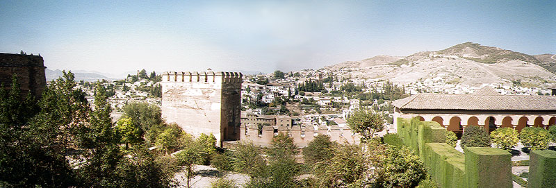
That changed immediately when we entered the old center beneath the Alhambra
hill. On the road which rises to the Alhambra ( there is only one, you
can't miss it) there is a number of good hotels with reasonable prizes.
We decided to take Hostal Landazzuri (Cuesta Gomerez, 24, phone: 22 14
06, english spoken) which is nearly on top of the hill, consequently offers
a very nice view on the old town and has a very beautiful rooms.